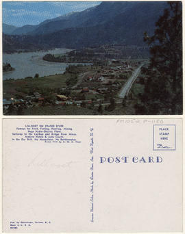
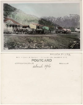
- AM1052-: AM1052 P-1189
- Item
- [192-?]
72 results with digital objects Show results with digital objects

A Lillooet Grizzly, Lillooet, B.C.
![[A paper window in St. Mary's Church]](/uploads/r/null/7/5/75a8745a311d50e8feb98eaae1fa9a19b708137602c38fd0ac7b16d153a0abbf/85631c22-3f31-412e-afa6-ce30db2304a9-A59882_142.jpg)
[A paper window in St. Mary's Church]
Part of Major Matthews collection
![[A street in Lillooet]](/uploads/r/null/1/7/172a9ba08b656595e4dd5145abe4cc1a921392cdfebdc6785610e71ca6bffa59/090a7323-e364-4089-9c94-274d508cf15e-A75643_142.jpg)
Part of James Crookall fonds
Photograph shows a hotel, Lillooet Garage and the Sunlight Cafe in the background
![[A street in Lillooet]](/uploads/r/null/7/5/757e1dc535942babfbde813f984c316382ef96d1a1407c433a089445d4da475b/5aa61626-522c-484e-950b-f17d521671a4-A75644_142.jpg)
Part of James Crookall fonds
Photograph shows a hotel, Lillooet Garage and the Sunlight Cafe in the background

Part of A.W. Phair fonds
Part of A.W. Phair fonds

Item is a postcard printed with an image of a man standing next to a large fish, which is hung from a wooden tripod. An annotation on the postcard's verso reads, "Judeau & sturgeon."
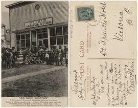
"Big game shooting" - a sportsman's paradise, Lilloett, British Columbia ....
This postcard includes personal correspondence. Sent to W. Johnston, proprietor, St. Francis Hotel, Victoria, B.C., from A.W.A. Phair.
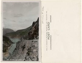

Cayoosh Creek Valley, Lillooet, B.C.
This postcard includes personal correspondence. Sent to Mr. J. Gregson of Vancouver, B.C.

Cummin's store with horse drawn covered wagon
Part of A.W. Phair fonds

Cummin's store with horse drawn covered wagon
Part of A.W. Phair fonds

Cummin's store with woman and dog
Part of A.W. Phair fonds
![[Duguid's boat at dock on Seton Lake]](/uploads/r/null/9/8/983f5ac25c2506bf681605bd79830da919479ca0c98592c0e7f6aacab67e7d32/948f24f5-3b3f-43f7-b8c8-9f08be612eb0-A59885_142.jpg)
[Duguid's boat at dock on Seton Lake]
Part of Major Matthews collection
![[Exterior of Casper Phair's residence "Longford House"]](/uploads/r/null/9/4/94628c2b87684188cf38a655f054624e7f689ef96028360d0015ba7e8376b9fe/9a81c4b1-4459-4118-86a9-542b24ebf902-A33615_142.jpg)
[Exterior of Casper Phair's residence "Longford House"]
Part of Major Matthews collection
Group portrait showing Mr. and Mrs. Phair, their sons A.W.A. "Arty" and Herbert, and, standing toward the back of the house is Chew, their Chinese servant.
![[Exterior of the Pioneer Hotel]](/uploads/r/null/5/b/5b2c66f7045acbc24acff8546e4dbc06856ce2c5834c4b99cd9270e61fb40a6c/5c9f4b82-a1b4-44ad-82f9-afe228a1227c-A26835_142.jpg)
[Exterior of the Pioneer Hotel]
Part of Major Matthews collection
![[Exterior of Victoria Hotel]](/uploads/r/null/c/e/ce0a029560fbad3e1fd4362ef686469ee14f2e4b4e25f995d157dc3fcf0f09ae/f0c08fe4-98d8-4167-b94d-9f909701e8c6-A26327_142.jpg)
Part of Major Matthews collection
Photograph shows Wilkins Bakery
![[Francis Gott]](/uploads/r/null/f/4/f402034d14f99c28edd6bdbac807d8d775faf6bc9d1536c165f29f32339ad751/a7824bb5-828b-436c-8970-f4e58af24fd9-A34205_142.jpg)
Part of Major Matthews collection
Head and shoulders portrait
![[Francis Gott tending to a dead grizzly bear]](/uploads/r/null/9/2/92db00b4105d40fec2329ca099b5a331b721d4155282b60cd3c9f811f705dab2/1834cd51-089d-408e-a968-835d46693d95-A34204_142.jpg)
[Francis Gott tending to a dead grizzly bear]
Part of Major Matthews collection
![[Frank Gott in the woods]](/uploads/r/null/c/5/c5a9b5793fa287139924ed17c9865d9da2605ac647f6c0520e3cb589cbe3cada/b2a9dad7-a4ca-4977-91c6-7b7f81e7a48f-A61707_142.jpg)
Part of Major Matthews collection
![[Frank Gott in the woods]](/uploads/r/null/1/3/13090a53a5acc433fe03b6bda2575d5367f70f37b1c69efb056244a2d7597da7/cfee9796-b1db-46e0-aa01-5a8a13079a37-A61706_142.jpg)
Part of Major Matthews collection

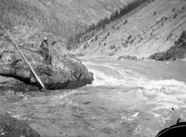
Fraser River at Lillooet, B.C.
Part of Major Matthews collection
Photograph shows Mount Chadwick
![[Group portrait outside the Phair residence "Longford House"]](/uploads/r/null/7/8/7828ebad333afd4e2d59f285ca3ec3bc969b4894a90931d35be8535a49cdf378/25263460-1d79-4f06-9ee7-40695655cbe1-A33624_142.jpg)
[Group portrait outside the Phair residence "Longford House"]
Part of Major Matthews collection
Photograph shows Mr. and Mrs. John Marshal, Emma Jane Marshall, Mr. and Mrs. Casper A. Phair, Mr. and Mrs. J.P. Forde, Mrs. A.W. Smith, Mr. Slipper, Herbert Lewis Phair, Colonel Reeves, Major Burnett, J. Brisco Cherry and Mr. McKinnon

Hydro electric surveys. Plan showing location of water powers investigated by City of Vancouver
Part of City of Vancouver fonds
Item is a map which shows the locations and the dates of use of "gauging stations established" and "city gauging stations still in use" in the area of south-western British Columbia where the City of Vancouver conducted hydro-electric surveys up to 1923.

Hydro electric surveys. Plan showing location of water powers investigated by City of Vancouver
Part of City of Vancouver fonds
Item is a map which functions as a visual index to the locations of various hydro electric surveys carried out by the City of Vancouver along the following rivers: Squamish River, Cheakamus River, Green River, Lillooet River, Eagle River, Indian River, Pitt River, Chehalis River, Harrison River, Chilliwack River, the Fraser and Thompson Rivers, and Bridge River. The map lists the names of the surveyors responsible and the areas covered by each survey. Annotations include the locations and the dates of use of "gauging stations established" and "city gauging stations still in use."
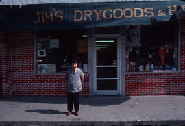
Image from Pender Guy oral history trip to Lillooet, B.C.
Part of Paul Yee fonds

Image from Pender Guy oral history trip to Lillooet, B.C.
Part of Paul Yee fonds

Image from Pender Guy oral history trip to Lillooet, B.C.
Part of Paul Yee fonds
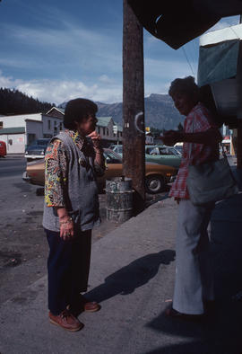
Image from Pender Guy oral history trip to Lillooet, B.C.
Part of Paul Yee fonds

Image from Pender Guy oral history trip to Lillooet, B.C.
Part of Paul Yee fonds

Image from Pender Guy oral history trip to Lillooet, B.C.
Part of Paul Yee fonds

Image from Pender Guy oral history trip to Lillooet, B.C.
Part of Paul Yee fonds
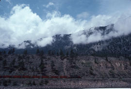
Image from Pender Guy oral history trip to Lillooet, B.C.
Part of Paul Yee fonds

Image from Pender Guy oral history trip to Lillooet, B.C.
Part of Paul Yee fonds

Image from Pender Guy oral history trip to Lillooet, B.C.
Part of Paul Yee fonds

Image from Pender Guy oral history trip to Lillooet, B.C.
Part of Paul Yee fonds
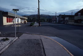
Image from Pender Guy oral history trip to Lillooet, B.C.
Part of Paul Yee fonds

Image from Pender Guy oral history trip to Lillooet, B.C.
Part of Paul Yee fonds

Image from Pender Guy oral history trip to Lillooet, B.C.
Part of Paul Yee fonds
Part of A.W. Phair fonds
![[J.C. Morrison and children outside the school]](/uploads/r/null/f/9/f9b1f7a9db404a9c05df3675d95811461e0ea1bcf44a64dc0bcfd33975c4219a/cbfdc65f-1aaa-46f6-a2c9-361263d389ed-A62273_142.jpg)
[J.C. Morrison and children outside the school]
Part of Major Matthews collection
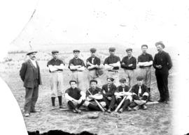
Group portrait showing Dan Copeland and others
![[Judge Fisher and an unidentified man]](/uploads/r/null/a/a/aaeb7fb4d2231ab7fe29b0a5824454f2f890c9c50a56f9d7941d5f0acfe83d5d/4b62e41d-ace3-49ec-a36a-39b932cdc17a-A59883_142.jpg)
[Judge Fisher and an unidentified man]
Part of Major Matthews collection
![[Lillooet]](/uploads/r/null/f/2/f2edcc4cff840488c2746c8e35e2ba90ca1e560948bd361b57d3fe323f014cd0/5bc13791-014b-45b5-88df-682e348974d7-A33610_142.jpg)
Part of Major Matthews collection
Photograph shows Mount Chadwick, the Methodist Church and other buildings
Part of Paul Yee fonds

Part of A.W. Phair fonds