The map shows the area currenlty occupied by Downtown Vancouver and parts of Kitsilano. It shows the location of C.P.R. Wharves, Hastings Saw Mill and other saw and shingle mills. "Note, Electric street railway shewn in Red."
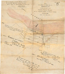
Item is a tracing of a map showing the Vancouver waterfront between Granville and Carrall streets. The original map contains a number of attestations which have been traced: by W.C. Van Horne (Mar. 11, 1886); H.J. Cambie, Engineer in charge (Feb. 22, 1886); T. Trudeau, Deputy Minister of Railways (31 Mar. 1886); and Land Registry office (12 May 1886). The Tracing was made from a copy submitted as an appendix to an affadvit May 28, 1891.
Item is a fire insurance map of the "Coal Harbour" [south shore of Burrard Inlet] area. The Hastings Saw Mill Company and Coal Harbour Fishery are shown in detail. Other businesses along Front Street are identified including hotels and stores.
The map shows the area currently occupied by Downtown Vancouver and parts of Kitsilano. It shows the location of C.P.R. Wharf, Royal City Saw Mills, Hastings Saw Mill and Wharf, Leamy and Kyle's Saw Mill and other saw mills. "Streets graded and side-walked marked thus . . . . .." An insert shows "Canadian Pacific Mail Steamship Lines" on a map of the world. The north shore of Burrard Inlet indicates the locations of "Indian Houses" and a mission church.


![Granville [Townsite], B.C. Aug., 1885](/uploads/r/null/1/a/4/1a45ddd637fe3f3726748d5096017a8461446b9a013c408ed2b1666c8433e1f9/405fdc0d-6d88-41b7-937f-36cc7f51518a-MAP553_142.jpg)
