Map of Port Moody and vicinity
- AM738-S1-: 1980-253.13
- Item
- 1912
Item shows roads and legal descriptions, soundings, harbour, and railway.
68 results with digital objects Show results with digital objects
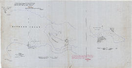
Map of Port Moody and vicinity
Item shows roads and legal descriptions, soundings, harbour, and railway.

First tea ship 'W.B. Flint' at Port Moody, left for China loaded with lumber

"Loading Lumber at Port Moody, B.C. - 1889"
Part of Major Matthews collection
Ship in foreground is the "Mirzapore."
![[Exterior of St. John's Anglican Church]](/uploads/r/null/f/a/fad82b1c9ed5ba7a70068dd1a2c0d6fdae65c4e60fb0eae945c2c707575ff792/29ee2ee0-7131-4f26-a171-41dd43294661-A25069_142.jpg)
[Exterior of St. John's Anglican Church]
Part of Major Matthews collection
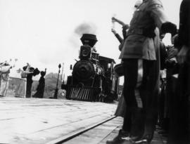
![[L.D. Taylor watching event from dock at Port Moody]](/uploads/r/null/b/2/b21b2f78a72a393036fdc38856244b05408617cd50c845a58652f3901aaa0d98/a2027544-d635-4192-b4d4-c9120abb0340-A49825_142.jpg)
[L.D. Taylor watching event from dock at Port Moody]
Part of L.D. Taylor family fonds
Photograph is incribed on the back: "From Ed. Humphreys, N.O.M.C., To "L.D.," With best wishes for 1931, E.H. Taken at Pt. Moody B.C., 1930."
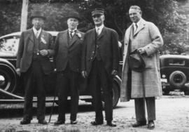
![[Group portrait of four men] upon the 50th anniversary of the arrival of the first transcontinent...](/uploads/r/null/0/9/092bbc59fee20d3a0870d43eeabb2d42126a7b5475119bcbf66a772cf1a3e2ee/de3a3e13-80ba-471f-b0f0-0cafb3f4ed97-A49733_142.jpg)
Photograph shows snapshot group portrait of W.H. Evans, P.A. Barnhart, Rt. Hon. R. B. Bennett and G. G. McGeer.

View of Imperial Oil Refinery at Ioco from Port Moody

Part of William Orson Banfield fonds
Item is a photograph showing two boys in a canoe at Port Moody.

The head of the inlet, Port Moody
Part of William Orson Banfield fonds

Home sweet home, Port Moody trip
Part of William Orson Banfield fonds
Item is a photograph showing two boys cooking over a fire outside of their tent.

Replica of first C.P.R train to Port Moody, July 3, 1886 : Approaching Port Moody
Part of William Orson Banfield fonds
![Replica of first C.P.R train to Port Moody, July 3, 1886 : At Port Moody [showing] McGeer, Bennet...](/uploads/r/null/3/0/a/30abd706e9ee3f7581780326ffb7267e58491f77888f2e49fb7ed1b89423ae00/de29c618-4ed7-45cb-bf75-ec737b2d6eb0-CVA289-005_142.jpg)
Part of William Orson Banfield fonds

Canadian Pacific Railway arrival of the first through train at the seabord of British Columbia
Part of Major Matthews collection
Photograph shows men next to C.P.R. locomotive 371 at the Port Moody railway station.
![[The first C.P.R. Station in Port Moody]](/uploads/r/null/f/a/8/fa85121f0e960c31c304611783cefda2a33f363aa71c5b4658947d177c8137e8/3c046e33-8130-41c8-92dc-53a30e7d7bb9-CVA371-1295_142.jpg)
[The first C.P.R. Station in Port Moody]
Part of Major Matthews collection
Photograph shows Mr. Ford, J. Bass, J.P. Phelan, Mr. Petridge, G. Storey, Mr. Preston, J.J. Mackin, Stanley Henderson, Bob Benedict, Evelyn Smith, James S. Fagan, Mr. Heward, George Morrow, William Downie, Fred Sinclair, A.J. Dana, Graham Boston, Luke Moore, J.J. Mulhall and others
![[View of a sawmill]](/uploads/r/null/5/4/54bfdfc432f77bb7a59dbcc6d0feb53ee25d390335f53975eb4eb30740d61f19/5eeeea4d-5c0a-444d-abfb-776717fb22b4-A59912_142.jpg)
Part of Major Matthews collection
![[Mr. and Mrs. Middler]](/uploads/r/null/f/2/f2fd2b6f27d997a5da0b73f07670419d8774c6bff5dfdb9b252591c7406b90c6/bddaf110-c54a-4eeb-ab56-ffec5b498730-A60773_142.jpg)
Part of Major Matthews collection
!["Brunette Butts" [Royal Engineer's Range, East Road]](/uploads/r/null/6/b/6bc8c5c95838d6dfbb521e7895a3a9b75a1bae5d7f4baa07467ddea0dba6b252/be9a9536-7dbe-48d3-a4ea-903058d17e05-A59735_142.jpg)
"Brunette Butts" [Royal Engineer's Range, East Road]
Part of Major Matthews collection
!["Brunette Butts" [Royal Engineer's Range, East Road]](/uploads/r/null/5/a/5a4d77dd21e5c2daa97679d032520a55bcc664bed8fc56ed0cbfdc6cbaa77812/1f8b84ab-e1c0-46df-a63a-113456e9fb49-A59736_142.jpg)
"Brunette Butts" [Royal Engineer's Range, East Road]
Part of Major Matthews collection

Replica Port Moody Station, 1886, ladies in dress of the period

Replica Port Moody Station, 1886, ladies in dress of the period
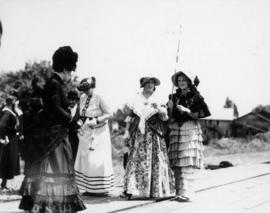
Ladies, in dress of the period, awaiting arrival of train at Port Moody, July 3, 1936

Port Moody, July 3, 1936, re-enactment arrival of first train, July 4, 1886


Engine No. 371 (replica) preparing to proceed from Port Moody to Vancouver


First Annual Banquet Refinery Employees Union Oil Company Limited at Burrard Club Port Moody, B.C.
Part of Stuart Thomson fonds
Group portrait
![[The first through train at the train station in Port Moody]](/uploads/r/null/4/f/4fb6c1cd7d27eaf96a8925406ebb83da222c551b100a20dd9be4b5ff28e1b6bb/03a09b44-3e52-4e64-9718-8907a1ae7288-A25307_142.jpg)
[The first through train at the train station in Port Moody]
Part of Major Matthews collection
Photograph shows Donald A. Ross, C.E.

Part of Major Matthews collection
![[Crowds at re-enactment of arrival of first train]](/uploads/r/null/c/8/c8294cc89b42408f8c85e0ec4da73b7d5ce2b29f76ab5114bc7187bc7a04e717/8287c650-8109-4eb2-9bc4-be1dc2f0724a-A25405_142.jpg)
[Crowds at re-enactment of arrival of first train]
Part of Major Matthews collection

Canadian Pacific Railway arrival of the first through train at the seabord of British Columbia
Part of Major Matthews collection
Photograph shows men next to C.P.R. locomotive 371 at the Port Moody railway station.
![[First through train, C.P.R. locomotive 371, to arrive at Port Moody]](/uploads/r/null/a/3/a3cb840085bd2e100d6d82dbb68afc41e863b95c0ab55a56c0ac3387e9b0f6b2/1f00dff5-8096-4298-bc4e-e354b20d3552-A25309_142.jpg)
[First through train, C.P.R. locomotive 371, to arrive at Port Moody]
Part of Major Matthews collection
![[Men and women gathered at platform next to C.P.R. locomotive 371]](/uploads/r/null/b/2/b24a111ab4c41095e04e8bbbc16c17b2a927c0bb7fc2cd56ad0465e77ecf4e6d/d5f9e94e-74a8-42d2-9d52-6c2fee90337d-A25310_142.jpg)
[Men and women gathered at platform next to C.P.R. locomotive 371]
Part of Major Matthews collection
Identified are A.G. McCandless, "Teny" Christina Robertson, Victoria, and Miss Lewis (Mrs W.H.R. Collister)
![[Arrival of Sir John and Lady Macdonald by C.P.R train at Port Moody]](/uploads/r/null/5/3/5375a0245325f3238a516c67e349fd882f20f861073d006da477724a99181695/3f291432-ae8c-4b36-9f6f-b83f2a1e3331-A25364_142.jpg)
[Arrival of Sir John and Lady Macdonald by C.P.R train at Port Moody]
Part of Major Matthews collection
People identified: 1. Mrs. Norman Fraser, 2. Mrs. John Fraser, 3. John Murray, 4. Miss Liah Scott, 5. E.K. Perry, 6. Miss Nellie Dockrill, 7. Mrs. E.K. Perry, 8. Norman Fraser, 9. T. J. Trapp, 10. Ham Lipsett, 11. first mate of ship"New York", 12. Mr. Simmonds, 13. Sir John A. MacDonald, 14. Lady MacDonald, 15. John R. Scott
![[Col. J.T. Scott's "Caledonia" Hotel]](/uploads/r/null/6/0/603fd37f1997c0a4c2c6e2a9df8b1d96cbd676bb979a5e09b736404a2e2458bc/45e7be5b-e959-4534-99af-ee55802a2c6e-A26277_142.jpg)
[Col. J.T. Scott's "Caledonia" Hotel]
Part of Major Matthews collection
![[Top of surge tank of hydraulic tunnel for Buntzen Lane Power Plant number two]](/uploads/r/null/9/f/9f1ad58287144ba1ce8eaf8ae537cc7a52b490729c943ca0f734df19bd54fdf8/a02c1048-21b5-4cc2-a93d-15a0c4868728-A08449_142.jpg)
[Top of surge tank of hydraulic tunnel for Buntzen Lane Power Plant number two]
Part of Major Matthews collection
![[Two views of Coquitlam Dam and Buntzen Lake Power Plant number two construction]](/uploads/r/null/9/0/90c2f9aa0ab26d7034f559b48982b55e711f9db28a9b8dce03e610a63b63730b/172ad02e-985a-43f0-b64d-f87fe8a89332-A08638_142.jpg)
[Two views of Coquitlam Dam and Buntzen Lake Power Plant number two construction]
Part of Major Matthews collection
Photograph negative is a copy of two photograph prints, showing: man with donkey in front of openings for hydraulic tunnels to be connected to the surge tank with penstocks for Buntzen Lake Power Plant number two; and water flowing over the spillway at the Coquitlam Dam. Negative was created in order to produce lantern slides of the two images.
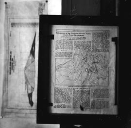
Enlargement of the Coquitlam-Buntzen hydro-electric power development
Part of Major Matthews collection
Photograph negative is a copy of a page from a Sept. 21, 1912 article in the "Engineering Record", containing a plan of dam and tunnels. Negative was created in order to produce a lantern slide of the image.
![[Cross section of headgate structure and New Westminster Water Works intake tower]](/uploads/r/null/e/7/e77f33fbac77e02fe5d428b3cbdfe9839aca02c42ef67efe86d05a8343812c1c/670c4ee9-1c4a-4e8d-9ef2-2d385988ddb0-A08652_142.jpg)
[Cross section of headgate structure and New Westminster Water Works intake tower]
Part of Major Matthews collection
Photograph negative is a copy of a page from a Sept. 12, 1912 article in the "Engineering Record", entitled "Enlargement of the Coquitlam-Buntzen hydro-electric power development". Negative was created in order to produce a lantern slide of the image.
![[Port Moody logging camp]](/uploads/r/null/5/8/58252c37f72c24935dcc3c852bdb52be00d02def2be82ae1ca889eb8eca3c9b7/87250a4b-e302-4b82-8d65-ae05d21ff9ce-A19576_142.jpg)
Part of Major Matthews collection
![[Port Moody logging camp]](/uploads/r/null/b/3/b3f990a8c13f219c23b33d80e2fe11b4fa6dd4e35b64ca10f5b883f90f3b2641/8d256d4b-bb07-43ec-876f-a6463aab692d-A19578_142.jpg)
Part of Major Matthews collection
![[C.P.R. main line Port Moody, section foreman]](/uploads/r/null/b/4/b4d68827ad0b776899929e3708ef96b91933a8e32fe86bf48149dd843887b7f9/7d25b567-930d-4537-8c12-e31ecd587b27-A19590_142.jpg)
[C.P.R. main line Port Moody, section foreman]
Part of Major Matthews collection
Photograph shows a man operating a handcart on a section of railroad tracks.
![[Sandy and E.A. Dickie with unidentified women in Port Moody]](/uploads/r/null/7/4/747e9c269dd509b2a96410bcc276163958944183bb638647e369c743f16972b8/ae43af46-d0f7-4b3c-8281-05276691d89c-A19603_142.jpg)
[Sandy and E.A. Dickie with unidentified women in Port Moody]
Part of Major Matthews collection
![[Unidentified men, children and building in Port Moody]](/uploads/r/null/8/a/8a6335664a0c92e70f9da037cd0564e0158e99d5d7f8fe200e80033d166137f6/723ef09d-e0f1-4c30-ad70-242e4a755f31-A19604_142.jpg)
[Unidentified men, children and building in Port Moody]
Part of Major Matthews collection
![[Logging horses, Port Moody]](/uploads/r/null/6/2/62b17a5f167da923c32e0086585ea1f7b126e1522a3e68b3215b461ff18be017/742e554e-a5b6-4712-8401-74ba064b6e9c-A19568_142.jpg)
Part of Major Matthews collection
Part of Major Matthews collection
Item consists of a tracing of two maps on one sheet, of a map most likely originally drawn in 1859 or 1860. Based on the copied annotations, this tracing appears to be at least a second (or possibly third) generation tracing from the original map created as a result of the H.M.S. Plumper surveys of the area at that time.
One map shows Burrard Inlet, Point Grey, Spanish Bank [sic], Point Atkinson, English Bay, Downtown Peninsula, Coal Peninsula, Brockton Point, First Narrows and False Creek, and proposed government land reserves in these areas. The second map shows Burrard Inlet and Port Moody and proposed government land reserves in this area.

Plan of the Town of Port-Moody, British Columbia
Part of City of Vancouver Archives technical and cartographic drawing collection
Item is a map showing Port Moody District Lots, blocks and lots, street names, and the "C. P. [Canadian Pacific] Railway Station" and the "C.P.R. [Canadian Pacific Railway] Wharf."

Port Moody, the western terminus of the Canadian Pacific Railway
Part of City of Vancouver Archives technical and cartographic drawing collection
Item is a map showing lots surveys and made available for purchase in Port Moody.