English Church, Courtenay, B.C.
- AM1052-: AM1052 P-1091
- Item
- [191-?]
English Church, Courtenay, B.C.

Southerly portion. Vancouver Island
Part of City of Vancouver Archives technical and cartographic drawing collection
Item is an economic map which depicts Vancouver Island south of Buttle Lake, as well as coastal areas of the mainland from the approximate location of Britannia Beach, south and the northern coast of the Olympic Peninsula. Information included in the map include Timber Licenses, Indian reserves, other land reserves, municipal boundaries, District Lots outside municipalities, geographic features (not including topography), transportation routes, and parks.

Part of City of Vancouver Archives technical and cartographic drawing collection
Item is a map showing railway lines from Kamloops to the Vancouver, homesteads, lands disposed of by the provincial government, Indian reserves, forest reserves and parks, timber berths, grazing leases and land sales, land grants and mining land sales. Inset shows Vancouver Island and its railway line.

Part of City of Vancouver Archives technical and cartographic drawing collection
Item is a map showing the Pacific Coast of British Columbia and Washington and Oregon states as surveyed by French explorer Jean-Francois de Galaup (Laperouse) in 1786, and the routes of his ships Astrolabe and Boussole. The map shows the Pacific coastline from Cap Rond (Tillamook Head) in Oregon at latitude 45 degrees and 40 minutes in the south to Baeie de Clonard (Beresford Bay, northwestern tip of Haida Gwaii) in British Columbia at latitude 54 degrees and 10 minutes in the north. Other major place names on the map include Nootka, Pointe Boisee, Baie St. Louis, Iles de Sartine, Mont Fleurieu, Cap Fleurieu, Cap Hector, Mont de la Touche, Baie de la Touche, and Baie de Clonard. Vancouver Island is shown as part of the mainland. Map includes latitudes and longtitudes as well as indication of elevations. Map is a plate from the "Atlas de Voyage de la Perouse".

Portions of New Westminster District and Vancouver Island
Part of Bushnell family fonds
Item is an economic map which depicts the area of central Vancouver Island made up of the Comox, Nelson, and Newcastle land divisions, as well as portions of the Alberni, Cameron and Nanoose land district. The map includes the inside passage islands between Lasqueti and Sonora Islands, and the coastal portion of the New Westminster land district from Bute Inlet south to the mouth of the north arm of the Fraser River.
Information included on the map includes timber licenses, Indian reservations, other government reserves, District Lots, physical features (not including topography), and municipal boundaries.


Vivian Neild, Win Parson & Joan Baker at Sooke church


Northerly portion Vancouver Island
Item is a map of northern Vancouver Island and the adjacent British Columbia coast showing Crown and reserve lands, timber leases, district, park, and provincial forest boundaries, cities, municipalities, villages, post offices, hospitals, roads, railways, seaplane ports and anchorages, airports, elevations of some geographical features, and marine distances in nautical miles.
![[View of] Little Qualicum Falls](/uploads/r/null/4/4/444ce78ed582a5760d5e6672b65530e5e3b12f77ceabe62c2c58b992d206088c/f5dbd7cb-1ace-4bcf-ae6a-3812087bb189-A72038_142.jpg)
[View of] Little Qualicum Falls
Part of Karl Haspel fonds
![[View of] Little Qualicum Falls](/uploads/r/null/4/0/4063dff1ad52452b8c6450e735ed8a45e6dc84f3e366ea55b5d6e5d54e9e973a/c4b3a4b5-7cfc-43d1-a4ef-fa382dad3929-A72039_142.jpg)
[View of] Little Qualicum Falls
Part of Karl Haspel fonds
![C.M.A. [Canadian Manufacturing Association] : Malahat Drive etc.](/uploads/r/null/9/6/0/960f08499243b76dec7193782b182048bb5f9ac9ed7bd23c363a2b12470fd16a/4cbfd568-9b31-4521-a630-0318094ed8aa-CVA586-15084_142.jpg)
C.M.A. [Canadian Manufacturing Association] : Malahat Drive etc.
![C.M.A. [Canadian Manufacturing Association] : Victoria](/uploads/r/null/a/6/e/a6e47638412936fa115ab496a64b2a8127c60a187ea8e4b4aa13c84310ba1a99/4999009d-4eb4-4053-9dbf-2ae46c6aed49-CVA586-15092_142.jpg)
C.M.A. [Canadian Manufacturing Association] : Victoria
![C.M.A. [Canadian Manufacturing Association] : Victoria](/uploads/r/null/f/c/f/fcfdc782c47636922df93078401d7832444d2243566d4731176588342e1723fb/c71b8dcf-884b-43a0-9444-bc8cc7bb4cf6-CVA586-15095_142.jpg)
C.M.A. [Canadian Manufacturing Association] : Victoria

Fairbridge Farm, Vancouver Island : farm scenes
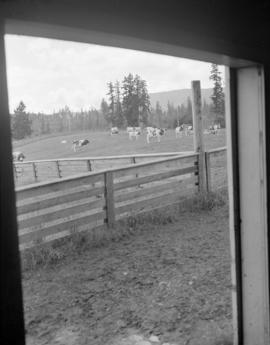
Fairbridge Farm, Vancouver Island : farm scenes
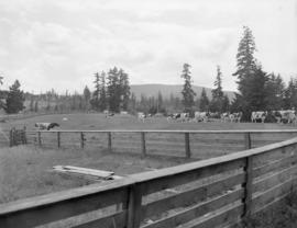
Fairbridge Farm, Vancouver Island : farm scenes

Blue Line Bus Co., Victoria, B.C. : buses on highway

Scenics Victoria : C.M.A. trip to Island
![Scenics Victoria : C.M.A. trip to Island [Goodyear blimp]](/uploads/r/null/5/3/b/53bf1eb9786f4b64e5d25fc25a00f2d76307fddb8f4d187058f2e5d680a3cb9c/aa877184-9cf1-4379-946b-4408afe10f0b-CVA586-15148_142.jpg)
Scenics Victoria : C.M.A. trip to Island [Goodyear blimp]

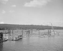
Comox Logging for Elk Falls Co. : Vancouver Island

Comox Logging for Elk Falls Co. : Vancouver Island

Campbell River town site : aerial, rollie, streets

Campbell River town site : aerial, rollie, streets


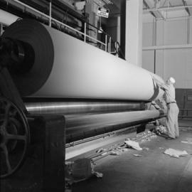


Elk Falls plant interiors : roll grinder


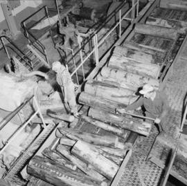
Elk Falls - Pacific Mills : personnel