- AM1594-: MAP 836
- Item
- 1795 [photocopied between 1973 and 1975]
Part of City of Vancouver Archives technical and cartographic drawing collection
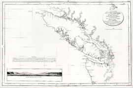
Map shows the discoveries made in 1792 on the north-west coast of North American by examining Juan de Fuca Strait and the corresponding navigable channels, prepared for Dionisio Galiano and Captain Valdes, naval captains of the Royal (Spanish) Fleet in the year 1795.


![Myrtle [Kilpatrick] and Olive [Sadler]](/uploads/r/null/2/2/a/22ae0074631268708a81b2647fa6c6d3a6d893c4b3007dcb789a11087d7dae2b/da34a586-a84c-4bbb-8416-fde3ccbf6515-CVA289-003_142.jpg)
![Art [Lord] and Myrtle [Kilpatrick]](/uploads/r/null/2/9/6/29681e7e966aaaadca36c2c242b75bf0f6265196b44867dea92348983e183cf0/7f38dafb-6bf6-4fbf-af24-ea549eb4adb5-CVA289-003_142.jpg)
![W.O. B[anfield]](/uploads/r/null/5/6/b/56b3c079e2acbb602cbe399aef90076a27aa04da390a5d7e22eebedcf438345c/7bcc418c-5711-4c46-8c27-bcb5b3b5618b-CVA289-003_142.jpg)
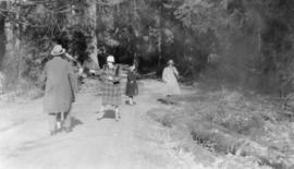
![[Olive Kilpatrick, Myrtle Kilpatrick and Olive Sadler] ready to start for Parksville](/uploads/r/null/8/4/e/84e5b76d02e75b8bf5aeb46b564dd3787ba2e3514d77cc54d275b5cba4575b50/bf7277c0-163e-486f-9ab0-524d2d6f6f1f-CVA289-003_142.jpg)

![Olive arguing with Myrtle [Kilpatrick]](/uploads/r/null/f/b/5/fb5e43c6c9885b6013666776c041dbf07f6ecc2cc842ad061a6171a76617d2e2/242a8de0-b973-450f-b843-3390a5d5d031-CVA289-003_142.jpg)

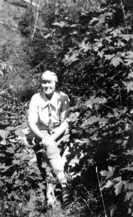
![Myrtle [Kilpatrick]](/uploads/r/null/0/0/e/00eb0b77a13bfa824ec6d3f8ef73553f073ef19c95c4de4431d7880bb4fe78c0/0f25f379-7ce2-45a3-9701-e92d8743e8b1-CVA289-003_142.jpg)
![Olive [Sadler] triumphant, Myrtle [Kilpatrick] recumbent](/uploads/r/null/3/c/d/3cdd092c58003b9f1564602cb27b75a6b6d9d5329ce8d2579ba5ae570dbfbbef/0ca04af8-9f49-47bf-b9ec-aafb07d8ec09-CVA289-003_142.jpg)
![Art [Lord] and W.O. B[anfield]](/uploads/r/null/5/3/f/53f0fcdb44ccfece88214d9155d19b7cc9ecf2e60e0f0d62c93476dc2854f56c/a4f5dc37-3e26-4f8c-a051-133c646a43ed-CVA289-003_142.jpg)
![West Coast trip [with Sherwood Lett, Arthur Lord, W.O. Banfield] : The picnic leaving the beach](/uploads/r/null/2/c/a/2caee8173fe25e1f11201a016da020341f0e7b41d8f2c5847af3cb033e85994e/542b242b-39ad-4112-b00c-dd96757f105a-CVA289-003_142.jpg)
![West Coast trip [with Sherwood Lett, Arthur Lord, W.O. Banfield] : The "Bedouin" in Ril...](/uploads/r/null/0/3/5/035fa0a7507dbc91d4bb5fd635d88f7302bf09a91b80cc5e790885cff7d185cd/20a764f5-2a88-4039-a137-945598d04dc8-CVA289-003_142.jpg)
![West Coast trip [with Sherwood Lett, Arthur Lord, W.O. Banfield] : The set complete, lifting the ...](/uploads/r/null/2/f/b/2fb07228d267632e04d07604b9bd34d8219abb57b2b2f08f1cb9d10adb521ca5/2b8db0f5-25df-4eaf-a0fb-6d99ce46baa1-CVA289-003_142.jpg)
![West Coast trip [with Sherwood Lett, Arthur Lord, W.O. Banfield] : Gathering the net in](/uploads/r/null/e/3/a/e3a3366241397bc9fa4b40afe97704d1bbd555369f8f1bfa50123ec9a339ffe1/ce17d5fa-4a10-4d4c-94d3-590a1a246d62-CVA289-003_142.jpg)
![West Coast trip [with Sherwood Lett, Arthur Lord, W.O. Banfield] : Some of our catch](/uploads/r/null/3/0/0/30024c016d3fd6a5d456fad118d31feb2b9cd0ecb41b53587b9b8854a96275aa/0a6a75b2-df01-451e-b062-8fb498b1c76f-CVA289-003_142.jpg)
![West Coast trip [with Sherwood Lett, Arthur Lord, W.O. Banfield] : Sherwood [Lett] in his dugout](/uploads/r/null/b/6/b/b6b93246213c96c15ebe8781d1f2260fd15eccace8f9e95c5eaa0c61512b333a/5b506369-d36d-42cd-99f3-6e526198a0e7-CVA289-003_142.jpg)
![West Coast trip [with Sherwood Lett, Arthur Lord, W.O. Banfield] : Our wolf fish](/uploads/r/null/2/0/f/20f109e479db7553825fec5d2918ae27aab724f9e3493bd3374e6a0999a40ad8/f3ed1610-09d6-4d7b-8374-908211993f19-CVA289-003_142.jpg)
![West Coast trip [with Sherwood Lett, Arthur Lord, W.O. Banfield] : The scow being loaded](/uploads/r/null/6/5/1/6515c8ea886c23f029fd699b055dbfbd7b7ff3f3a7eecbabb212c244aef74630/0cfcce07-0894-4f15-98d9-84b1f4e60d59-CVA289-003_142.jpg)
![West Coast trip [with Sherwood Lett, Arthur Lord, W.O. Banfield] : Getting dinner on the "Be...](/uploads/r/null/6/3/2/6326b5d85f9f6e8ae0479b296399bfadef897844da1ebeb760704e402f41d52b/1a5659c2-116a-46f9-8088-cbca5c27066a-CVA289-003_142.jpg)
![West Coast trip [with Sherwood Lett, Arthur Lord, W.O. Banfield] : Lagoon in North Arm of Sidney ...](/uploads/r/null/d/a/3/da309305ba5dfbe6fc4d3a975b07fd3a6dc549f236160c2f0002ac52c62d961c/ce137057-6be8-4db2-bcb4-a64e073beadb-CVA289-003_142.jpg)
![West Coast trip [with Sherwood Lett, Arthur Lord, W.O. Banfield] : Megin River](/uploads/r/null/f/7/2/f7279ddc914ac9b87843e908c97d6652752c2e844bdb916faf19ae7a890dfb89/c2b4ae58-ebd1-4b21-91d3-0d5cbbad0e3b-CVA289-003_142.jpg)
![West Coast trip [with Sherwood Lett, Arthur Lord, W.O. Banfield] : Looking out of Riley's Cove](/uploads/r/null/9/4/1/9419eba203962b56153fcf59f5f913195937aabfd74062251cb908b04476f412/57ca2b33-fbb5-4664-b3b7-29224978fb5f-CVA289-003_142.jpg)
![West Coast trip [with Sherwood Lett, Arthur Lord, W.O. Banfield] : Sherwood [Lett] the fisherman](/uploads/r/null/d/8/b/d8bef33ca4b26b007589fcd07f6e9f858830e4076653b29b32fece04c16b16b0/b1895109-062f-4d40-b87f-24ea86fc4cb2-CVA289-003_142.jpg)
![West Coast trip [with Sherwood Lett, Arthur Lord, W.O. Banfield] : Dumping the silver horde](/uploads/r/null/0/f/3/0f3e3d90e7bf32b7472b25ce46f3c6c63f78c68e71905c29a86a31077f37a9e4/d90c43e7-7e1e-4992-950b-3aead4760594-CVA289-003_142.jpg)
![West Coast trip [with Sherwood Lett, Arthur Lord, W.O. Banfield] : Brailing fish](/uploads/r/null/c/8/a/c8a0408a587b5f8aba7c66deeb0c6812ed37a0e32832894c9d8ecdb0ce7c31b0/00539abd-8467-4d4d-ab2f-37d8ec0cfc74-CVA289-003_142.jpg)
![West Coast trip [with Sherwood Lett, Arthur Lord, W.O. Banfield] : Our noble vessel [The Bedouin]](/uploads/r/null/1/4/d/14dd0986b77a7390f20565f285896a03467076e632ed443a813d5b36361055e0/dfe4eac3-ed8f-4339-8d51-e23ef4fcb9a8-CVA289-003_142.jpg)
![West Coast trip [with Sherwood Lett, Arthur Lord, W.O. Banfield] : Lagoon at Megin River](/uploads/r/null/f/2/e/f2ea2140c729b22a745d5966404ed3711eea353fbb7ff509df370ebf8429c98e/af7058e2-36ed-4a0b-bacd-5336166902df-CVA289-003_142.jpg)
![West Coast trip [with Sherwood Lett, Arthur Lord, W.O. Banfield] : Lower reaches of Trout River](/uploads/r/null/b/2/e/b2eef641593160732bc00be405bee31d18fcd91a4de91130c9bd34ee2729a531/6c3d55e6-de11-4dcf-b6fc-d5674240eb4c-CVA289-003_142.jpg)
![West Coast trip [with Sherwood Lett, Arthur Lord, W.O. Banfield] : Art [Lord] fishing in Trout River](/uploads/r/null/c/c/a/ccab4317f563529cebd8372c99467266b9bf5a80a0101d414ced94d21c286ae4/0798ff25-1601-4f04-8cf7-0fe8a7108d64-CVA289-003_142.jpg)
![West Coast trip [with Sherwood Lett, Arthur Lord, W.O. Banfield] : Our wolf fish](/uploads/r/null/e/7/e/e7e85141590664ee1841d469cafe03cff3e9aeb691447bd426e0b9845a35da85/5857d61d-6092-4a4b-b617-785e31e77730-CVA289-003_142.jpg)
![West Coast trip [with Sherwood Lett, Arthur Lord, W.O. Banfield] : Starting the brail](/uploads/r/null/2/d/e/2de617b3392489d33f277e962ecd28184efd5f66d425d061b9fb7faaf9e2770a/c8eaff7c-5cc6-4e98-a83f-d36433242500-CVA289-003_142.jpg)