1957 edition road map, Surrey municipality
- AM738-S1-: 1980-253.07
- Item
- 1957
Item is a road map of Surrey and includes inset maps of North Surrey, White Rock, fire areas and wards, as well as a street index.
27 results with digital objects Show results with digital objects
1957 edition road map, Surrey municipality
Item is a road map of Surrey and includes inset maps of North Surrey, White Rock, fire areas and wards, as well as a street index.
[Map of Delta and South Surrey]
Part of Douglas Stewart Scott fonds
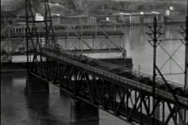
Item is an amateur film which captures shots of the New Westminster Bridge (also known as the Frasier River Swing Bridge) and the Pattullo Bridge. In the film, the swing mechanism of the New Westminster Bridge is shown as ships pass through, and the span then returns to allow the waiting vehicle traffic to pass. Following shots capture a man climbing on the underside of the through arch Pattullo Bridge.

Flowers, horses, painting Pattullo Bridge
Part of Douglas Stewart Scott fonds
Item is an amateur film which captures flowers, trees, and foliage, with the British Columbia Parliament buildings at times visible in the background; and women riding horses and playing with a dog. The latter half of the film captures labourers painting the Pattullo Bridge (New Westminster, B.C.) while hoisted on pulleys or simply free climbing. The workers, covered with paint themselves, pose together at the end of the film.
![[J.A. Cates residence at Crescent Beach]](/uploads/r/null/f/1/f1ff04e3653658a52604ae05451b67134144cf4011f7528e29b026eba02dd870/e28d1dfc-6711-4c20-806c-4dd36d6427c5-A08958_142.jpg)
[J.A. Cates residence at Crescent Beach]
Part of Major Matthews collection
Photograph shows beach, houses, cars, and girls with horse next to fence.
![[J.A. Cates residence at Crescent Beach]](/uploads/r/null/1/1/110bfe89cddd961ed9da5923519385f9a326954bdce47e911f2df0a7aa9abee5/f5201b49-647e-4e1e-b3e5-ded903507aa8-A08959_142.jpg)
[J.A. Cates residence at Crescent Beach]
Part of Major Matthews collection
Photograph shows various people on beach in front of house.
![[J.A. Cates residence at Crescent Beach]](/uploads/r/null/e/b/ebb2e48a40d9fb7dd70b5b216cca0fcdb9ae499b9b54d5723dd3eca1e41510af/0e2beab7-f521-4a30-8973-870f5592d2b0-A08960_142.jpg)
[J.A. Cates residence at Crescent Beach]
Part of Major Matthews collection
Photograph shows cars parked by house and people on balconies or sitting on benches at the beach.
![[J.A. Cates residence at Crescent Beach]](/uploads/r/null/2/f/2f280b8abea096e73f8766318e2944ed040f3444c9e6fb68d8510996b63459ad/7d894d07-08bb-43b7-ac3f-8c4f2794c631-A08961_142.jpg)
[J.A. Cates residence at Crescent Beach]
Part of Major Matthews collection
Photograph shows people and cars on beach in front of lake.

Item is a photograph showing oxen logging at Nicomekl River, Mud Bay, B.C.
![[Boundary Treaty Centennial celebration at the Peace Arch border crossing]](/uploads/r/null/8/f/8f6746f809d4748b7e089d0548004e88a3fcd4369bbffc429b6b34c23bc26879/26e4505c-5a55-444e-ac8f-9160213690ed-A12697_142.jpg)
[Boundary Treaty Centennial celebration at the Peace Arch border crossing]

![[Sea cadet band marching past the Peace Arch at the Boundary Treat Centennial celebration]](/uploads/r/null/e/b/eba9156d8f135c55d7b8ece5488b541cbbf9a739eb04f504f76afaf3ef777fb8/20f50f23-eb1b-4241-9918-0ec0c2c727d8-A12700_142.jpg)
[Sea cadet band marching past the Peace Arch at the Boundary Treat Centennial celebration]

Hydro technicians working on tower at 104th Ave. and 140th St., Surrey
Part of Vancouver Express fonds
Item is a photograph showing hydro technicians working on tower at 104th Ave. and 140th St. in Surrey. Caption from Vancouver Express: "Skillfully balancing on power transmission lines, Hydro technicians work on tower at 104th Avenue and 140th Street in Surrey. New line will bring power to Lower Mainland from Bennett Dam on the Peace River."

Riot equipped American police and youths from Blaine confront Canadian group at Peace Arch Park
Part of Vancouver Express fonds
Item is a photograph showing riot equipped American police and youths from Blaine confronting Canadian group at Peace Arch Park. Caption from Vancouver Express: "Riot-equipped American policeman backed up by squad cars and paddy wagons stand behind youths from Blaine as they confront Canadian group at Peace Arch Park. Demonstration became violent when Canadians crossed the border in symbolic invasion. Fighting started when the Stars and Stripes was torn from a flag pole."

Crowds of demonstrators at Peace Arch Park
Part of Vancouver Express fonds

Fred Buchamer, candidate for Alderman, Surrey
Part of Pacific Press fonds
![[Woman standing in front of Peace Arch monument during its construction]](/uploads/r/null/3/4/345c143a4fba298690b408a1986292604dfa9ab5df22e69f9dbad10589274d06/9cf6a2c4-4258-427f-accd-adf4c2d2cb5e-CVA1477-1385_142.jpg)
[Woman standing in front of Peace Arch monument during its construction]
Part of L.D. Taylor family fonds
![[Group of people standing under Peace Arch monument during its construction]](/uploads/r/null/6/4/649adf4615101272bd3ab5a8bb98ec47188da9cb409c5e9435872e89cdbb106a/47395b85-5f5a-4a8a-b729-035757cbd792-A73000_142.jpg)
[Group of people standing under Peace Arch monument during its construction]
Part of L.D. Taylor family fonds


![Pinus Contorta at S[outh] Westminster](/uploads/r/null/f/c/fcda262372c750befdbeccdf0e8b294809b17d5c06ab2a45bb829641c9a7d3d5/923cd107-0892-41f1-bbd2-88caccb6d4dd-A50661_142.jpg)
Pinus Contorta at S[outh] Westminster
Part of John Davidson fonds
Scott MacDonald, Norman's grandson
Part of Hamber family fonds
![[187 176 Street, Surrey]](/uploads/r/null/0/6/8/0687d8693b7d4ef6450ba8780728df831bfe04a2e65875cf79f2de04f08a6b25/f495228a-fa68-4fcd-963e-fca1e508e48b-CVA786-97_142.jpg)
Part of City of Vancouver fonds
Item is a photograph showing the Tudor Inn Hotel.

Part of City of Vancouver Archives technical and cartographic drawing collection
Part contains street maps of the University Endowment Lands, Surrey, Maillardville, Lulu Island and Sea Island, tourist information about Vancouver, and text advertising the products and services of the Dominion Map and Blueprint Company.

Part of City of Vancouver Archives technical and cartographic drawing collection
Part contains street maps of Lulu Island and Sea Island, Delta, Surrey, Langley, and Maillardville, tourist information about Vancouver, and text advertising the products and services of the Dominion Map and Blueprint Company.
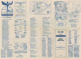
Dial map of the city of Vancouver including the adjacent municipalities
Item is a street map showing Vancouver, Burnaby, New Westminster, West Vancouver and North Vancouver on one side and the University Endowment Lands, Surrey, Maillardville, Lulu Island and Sea Island on the other.
Part contains street maps of the University Endowment Lands, Surrey, Maillardville, Lulu Island and Sea Island, tourist information about Vancouver, and text advertising the products and services of the Dominion Map and Blueprint Company.
Item is a street map showing Vancouver, Burnaby, New Westminster, West Vancouver, and North Vancouver on one side and Lulu Island and Sea Island, Delta, Surrey, Langley and Maillardville on the other.

Part contains street maps of Lulu Island and Sea Island, Delta, Surrey, Langley, and Maillardville, tourist information about Vancouver, and text advertising the products and services of the Dominion Map and Blueprint Company.

Fraser Valley, Surrey & Richmond
Part of City of Vancouver Archives technical and cartographic drawing collection
Part consists of the front side of a published road map. This side contains road maps of the Fraser Valley, Richmond, and Surrey, as well as street indexes.
![[H.S. Rowling's logging camp]](/uploads/r/null/9/5/955399ea026ce23928503f32b3590a866567fc24c04de1a52bd261593f8f4c39/54ff5bac-6bfa-4b6a-9446-51976a491fde-A31945_142.jpg)
Part of Major Matthews collection
Photograph shows yoked oxen and loggers
Dial map of the city of Vancouver including the adjacent municipalities
Part of City of Vancouver Archives technical and cartographic drawing collection
Item is a street map showing Vancouver, Burnaby, New Westminster, West Vancouver and North Vancouver on one side and the University Endowment Lands, Surrey, Maillardville, Lulu Island and Sea Island on the other.
Street map of Greater Vancouver
Part of City of Vancouver Archives technical and cartographic drawing collection
Item is a published road map, created for and distributed by Home Oil Distributors, with a map of Greater Vancouver on one side and maps of the Fraser Valley, Surrey and Richmond (iwth street indexes) on the other. The maps show roads, block numbers, boundaries, highway markers and Home Oil gas stations.
Education - school districts - Surrey - to 1997
Part of BC Gay and Lesbian Archives
Education - school districts - Surrey - 1998
Part of BC Gay and Lesbian Archives
Education - school districts - Surrey - 1999
Part of BC Gay and Lesbian Archives
Education - school districts - Surrey - 2000-01
Part of BC Gay and Lesbian Archives
Education - school districts - Surrey - 2002-03
Part of BC Gay and Lesbian Archives
Education - school districts - Surrey - 2004-17
Part of BC Gay and Lesbian Archives
Part of BC Gay and Lesbian Archives
Part of BC Gay and Lesbian Archives
Part of BC Gay and Lesbian Archives
New Westminster Land District - New Westminster Land Recording District (Surrey, B.C.)
New Westminster Land District (Surrey, B.C.)
Soil capability map of Surrey (Surrey, B.C.)