![[View of the Lulu Island Bridge to Sea Island]](/uploads/r/null/e/c/ec3f7ba82e8118833f32d3dd63180063b4263f6e3c0a0faa28f51941e8ab12df/940bae95-6a2a-42b4-b37a-c04e09ff1b25-A26746_142.jpg)
[View of the Lulu Island Bridge to Sea Island]
- AM54-S4-: Out P5
- Item
- [ca. 1890]
Part of Major Matthews collection
12 results with digital objects Show results with digital objects
[View of the Lulu Island Bridge to Sea Island]
Part of Major Matthews collection
![[Looking north across the Fraser Street Bridge]](/uploads/r/null/d/e/de994df835bdcfdaa203146063370a3f06f4c249f9c860e283aaeb425481f5b7/c0bcc202-64e0-4a3c-9389-490317c3b5b0-A61151_142.jpg)
[Looking north across the Fraser Street Bridge]
Part of Major Matthews collection
Bridges over Fraser River at Eburne
Part of Stuart Thomson fonds
Oblique view showing the Marpole (Eburne) Low Level Rail Bridge and the Marpole Low Level Highway Bridge from Sea Island and Duck Island
![[North Arm Bridge, Sea Island]](/uploads/r/null/1/0/10a582832d25f36f580ea5f85b55ab839bd9bd7cb282d7f4e8fc8e19e0d81e6f/6711c6a3-6a86-4e39-833c-1289327ec3f5-A04127_142.jpg)
[North Arm Bridge, Sea Island]
Part of Major Matthews collection
Photograph shows shoreline, river, and bridge.
![[Looking north across the Fraser Street Bridge]](/uploads/r/null/5/9/5990778eeb0298950a4e2cf2ea7d1f76901a98bbcd31e8559ded24757908f7be/78ee6f5d-8615-4165-ae58-e8af3f87ab48-A61150_142.jpg)
[Looking north across the Fraser Street Bridge]
Part of Major Matthews collection
![[Looking north from the Fraser Street Bridge showing the open swing span]](/uploads/r/null/e/a/ea8c8f697b378adfc0b20f3e4233799fdbb4471e2c7b6f76f39d297e673d6feb/0a75a84b-ec8a-472e-99ae-2bf7b57f92c7-A61149_142.jpg)
[Looking north from the Fraser Street Bridge showing the open swing span]
Part of Major Matthews collection
![[Muriel Cornish, Wilfred Cornish, and Mary Tait on Marpole Bridge near Grauer's Store]](/uploads/r/null/8/3/837d30aa3003bb8e9840c9c50d329db2ed4b4d71cf163b2b930dfd29110bb6e1/0b0e25b5-7072-4f29-96e5-0260d0f9fdfd-A04495_142.jpg)
[Muriel Cornish, Wilfred Cornish, and Mary Tait on Marpole Bridge near Grauer's Store]
Part of Major Matthews collection
J.S. Matthews' notes with print or negative in Archives.

Looking north towards South Vancouver over Fraser Avenue Bridge
Part of Major Matthews collection

Southern end Fraser Avenue Bridge
Part of Major Matthews collection

Fraser Ave. bridge over North Arm - Fraser River
Part of Major Matthews collection
Item is a photograph showing the gates of the draw bridge and bridge tender Thomas Dodson is standing far right.
Looking north from the Fraser Street Bridge showing the open swing span
Part of Major Matthews collection

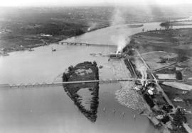
Aerial photo, vertical, Marpole and junction of Fraser River, Bridgeport
Item is a photograph of Marpole and northern Richmond, looking north. The area photographed centres on the fork of the Fraser River at Sea Island, and runs from W 67th Avenue to Cambie Rd., and from the western most tip of Richmond Island to the west tip of Mitchell Island. Includes the Marpole Bridge and both Oak Street and Moray bridges under construction.