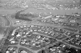
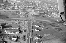
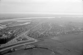
![[Aerial view of shopping centres]](/uploads/r/null/d/2/d21dcc14ced0356484b5666789f851fac68a175214b4718fae1444fec7417944/1f264270-6b68-43e6-be2e-f5b59df5d035-A71605_142.jpg)
Showing 25 results
Archival description24 results with digital objects Show results with digital objects
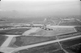
![[Aerial view of Richmond Centre mall]](/uploads/r/null/2/e/2ee69f17353dd5eafd9d3c5d8d0ae7f95f74b5669c564c68a4c72ffafb9cda20/e0752fe7-4588-4c42-a25c-ef561bf4ed68-A71603_142.jpg)
[Aerial view of Richmond Centre mall]
- AM1376-: CVA 1376-639
- Item
- [198-?]
Item is a photograph showing the Richmond Centre shopping mall as well as Samuel Brighouse Elementary School and Minoru Park.
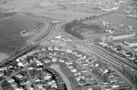
![[Aerial view of shopping centres]](/uploads/r/null/1/0/10ff59da2ba368988732f96fd1cd6e8fa091b0be501fa556439f7a93e5f7da6e/ac882c6d-a7cb-45e1-94f7-e89b0f645a16-A71607_142.jpg)

Air Canada Viscount airplane and Y5 ramp on tarmac
- AM1376-F12-: CVA 290-15
- Item
- March 1971
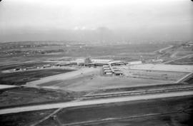
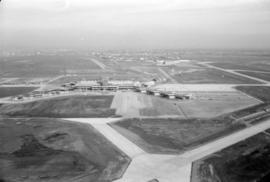
Aerial view of airport terminal, runways and approaches to Sea Island
- AM1376-F12-: CVA 290-16.01
- Item
- [ca. 1968]
- AM1376-F12-: CVA 290-16.13
- Item
- [ca. 1968]
- AM1376-F12-: CVA 290-16.16
- Item
- [ca. 1968]
Aerial view of airport terminal, runways and approaches to Sea Island
- AM1376-F12-: CVA 290-16.02
- Item
- [ca. 1968]

Aerial view of airport terminal, runways and approaches to Sea Island
- AM1376-F12-: CVA 290-16.04
- Item
- [ca. 1968]

Aerial view of airport terminal, runways and approaches to Sea Island
- AM1376-F12-: CVA 290-16.06
- Item
- [ca. 1968]
Aerial view of airport terminal, runways and approaches to Sea Island
- AM1376-F12-: CVA 290-16.10
- Item
- [ca. 1968]

- AM1376-F12-: CVA 290-16.14
- Item
- [ca. 1968]
- AM1376-F12-: CVA 290-16.15
- Item
- [ca. 1968]

Aerial view of Vancouver airport, aircrafts at terminal
- AM1376-F12-: CVA 290-14
- Item
- [ca. 1968]

Aerial view of airport terminal, runways and approaches to Sea Island
- AM1376-F12-: CVA 290-16.05
- Item
- [ca. 1968]

Aerial view of airport terminal, runways and approaches to Sea Island
- AM1376-F12-: CVA 290-16.07
- Item
- [ca. 1968]
- AM1376-F12-: CVA 290-16.12
- Item
- [ca. 1968]

- AM1376-F12-: CVA 290-17
- Item
- [ca. 1968]
Aerial view of airport terminal, runways and approaches to Sea Island
- AM1376-F12-: CVA 290-16.03
- Item
- [ca. 1968]

Aerial view of airport terminal, runways and approaches to Sea Island
- AM1376-F12-: CVA 290-16.08
- Item
- [ca. 1968]
Aerial view of airport terminal, runways and approaches to Sea Island
- AM1376-F12-: CVA 290-16.09
- Item
- [ca. 1968]

- AM1376-F12-: CVA 290-16.11
- Item
- [ca. 1968]
- AM1376-F12
- File
- 1967-1971
File consists of 32 photographs showing aerial views of the Vancouver Airport, Sea Island, Richmond, and the Fraser River. Also included are various shots showing the belly-landing of a small airplane.

Aerial view of Vancouver airport, Sea Island
- AM1376-F12-: CVA 290-13
- Item
- 1967

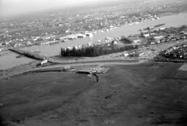
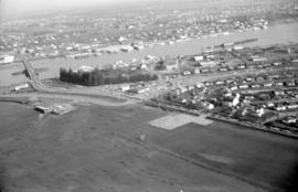
Aerial photo, vertical, Marpole and junction of Fraser River, Bridgeport
- AM1376-: CVA 59-11
- Item
- May 1956
Item is a photograph of Marpole and northern Richmond, looking north. The area photographed centres on the fork of the Fraser River at Sea Island, and runs from W 67th Avenue to Cambie Rd., and from the western most tip of Richmond Island to the west tip of Mitchell Island. Includes the Marpole Bridge and both Oak Street and Moray bridges under construction.