
- AM1376-: CVA 1376-360
- Item
- June 1947
Photograph shows the rocket designed by Lew Parry for the Sheet Metal Workers Union 280 float in the 1936 P.N.E. Parade at the entrance to the terminal on Sea Island
38 results with digital objects Show results with digital objects
Photograph shows the rocket designed by Lew Parry for the Sheet Metal Workers Union 280 float in the 1936 P.N.E. Parade at the entrance to the terminal on Sea Island

Small propeller plane belly-landing, hangars in background

Rescue helicopter hovering above plane

Ministry of Transport Rescue Helicopter, Fire Control vehicles arriving
Ministry of Transport personnel standing at forward-end of airplane

Long shot of crash scene, showing plane, rescue vehicles and personnel
![[Gracie Fields waving from the door of a Trans Canada Air Lines airplane]](/uploads/r/null/b/d/bd53df9348a862c946b11cec8ede026d3d73888c733ca16f67595a9bbf9a2b03/d4583f67-ac50-4744-b69b-45ff0a45c47c-A71755_142.jpg)
[Gracie Fields waving from the door of a Trans Canada Air Lines airplane]

Fire engines and belly-flopped plane,fire retardent foam being applied

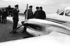
Belly-landing of small propeller plane (CF-CGJ) on runway

Belly-landing of small propeller plane (CF-CGJ) on runway

Belly-landing of small propeller plane (CF-CGJ) on runway
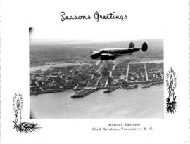
Airways Division, Season's Greetings
Item is an Airways Division Season's Greetings card showing an aerial view of the Burrard Inlet and West End with Ministry of Transport plane in foreground.

Airways Division, Season's Greetings
Item is an Airways Division Season's Greetings card showing a Ministry of Transport prop plane with the North Shore mountains in background.

Airplane covered with fire retardant foam on runway

Air Canada Viscount airplane and Y5 ramp on tarmac

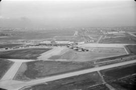
Aerial view of Vancouver airport, Sea Island

Aerial view of Vancouver airport, aircrafts at terminal
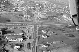
![[Aerial view of shopping centres]](/uploads/r/null/d/2/d21dcc14ced0356484b5666789f851fac68a175214b4718fae1444fec7417944/1f264270-6b68-43e6-be2e-f5b59df5d035-A71605_142.jpg)
![[Aerial view of shopping centres]](/uploads/r/null/1/0/10ff59da2ba368988732f96fd1cd6e8fa091b0be501fa556439f7a93e5f7da6e/ac882c6d-a7cb-45e1-94f7-e89b0f645a16-A71607_142.jpg)
![[Aerial view of Richmond Centre mall]](/uploads/r/null/2/e/2ee69f17353dd5eafd9d3c5d8d0ae7f95f74b5669c564c68a4c72ffafb9cda20/e0752fe7-4588-4c42-a25c-ef561bf4ed68-A71603_142.jpg)
[Aerial view of Richmond Centre mall]
Item is a photograph showing the Richmond Centre shopping mall as well as Samuel Brighouse Elementary School and Minoru Park.
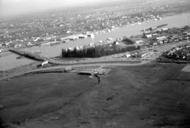


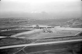
Aerial view of airport terminal, runways and approaches to Sea Island
Aerial view of airport terminal, runways and approaches to Sea Island

Aerial view of airport terminal, runways and approaches to Sea Island

Aerial view of airport terminal, runways and approaches to Sea Island
Aerial view of airport terminal, runways and approaches to Sea Island

Aerial view of airport terminal, runways and approaches to Sea Island

Aerial view of airport terminal, runways and approaches to Sea Island
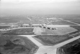
Aerial view of airport terminal, runways and approaches to Sea Island

Aerial view of airport terminal, runways and approaches to Sea Island
Aerial view of airport terminal, runways and approaches to Sea Island

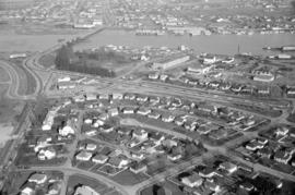
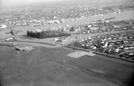
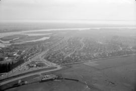
Aerial photo, vertical, Marpole and junction of Fraser River, Bridgeport
Item is a photograph of Marpole and northern Richmond, looking north. The area photographed centres on the fork of the Fraser River at Sea Island, and runs from W 67th Avenue to Cambie Rd., and from the western most tip of Richmond Island to the west tip of Mitchell Island. Includes the Marpole Bridge and both Oak Street and Moray bridges under construction.