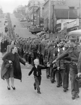
"Wait for me Daddy"

[View of street in New Westminster taken from a Westminster and Vancouver Tram Company caboose after the fire]

[View of Columbia Street, New Westminster, decorated with banners and flags, looking east from 8th Street]
![[View of Columbia Street from Begbie Street after the fire]](/uploads/r/null/9/e/9e4dec33bb4620d4856992e51992f5441b0d5a2697908885a9c9cfe45d5675d3/2002ab05-3851-4e5c-a3b2-4e70da6dcc47-A33028_142.jpg)
[View of Columbia Street from Begbie Street after the fire]
![[View of Columbia Street]](/uploads/r/null/e/f/ef93d73651c288cd13bec183ae441b073bef56fd8e1478d1e8606db139c05f97/fffbb383-9d42-4db1-944b-a41bd8bd0042-A33175_142.jpg)
[View of Columbia Street]
![[View of Columbia Street]](/uploads/r/null/5/4/54eced867db69ed084037b81efedfe66e18b836275808398e6d7d8df2b8e00f5/21889ce7-573a-4dd0-a27f-769cd8194f18-A61052_142.jpg)
[View of Columbia Street]
![[View of 6th Street near Queens Avenue looking south toward Royal Avenue]](/uploads/r/null/b/1/b160f7797343556b798a72318857b08502b193549f365d8e89ebdf0249172387/6353b72d-7ccd-45de-b0dc-0f034f9211f6-A61044_142.jpg)
[View of 6th Street near Queens Avenue looking south toward Royal Avenue]

Transit detail inset maps ; Street index ; Transit and tourist information

Town-site of Hastings
![[The King Edward Hotel 400-block Columbia St., New Westminster]](/uploads/r/null/9/8/9835ce24059bcaab32b6b8bd51ced5839e0679da3914f98154849d0076e2eb6f/4c737700-9ea9-4fc9-91e9-3be02e101995-CVA810-41_142.jpg)
[The King Edward Hotel 400-block Columbia St., New Westminster]
Sectional map and street directory of Vancouver : Dial map of the city of Vancouver including adjacent municipalities
Sectional map and street directory of Vancouver : Dial map of the city of Vancouver including adjacent municipalities
Sectional map and street directory of Vancouver : Dial map of the city of Vancouver including adjacent municipalities
Sectional map and street directory of Vancouver : Dial map of the city of Vancouver including adjacent municipalities
Sectional map and street directory of Vancouver : Dial map of the city of Vancouver
Sectional map and street directory of Vancouver : Dial map of the city of Vancouver
Sectional map and street directory of Vancouver : Dial map of the city of Vancouver
Sectional map and street directory of Vancouver : Dial map of the city of Vancouver
![[Retail and Office building on Columbia St., New Westminster]](/uploads/r/null/6/1/611ef86761a3abd14c8174edb58d4be410fc0273e4634942c8921c35723db0b9/889bfb27-3706-4882-b3d2-579b1d96dbc2-CVA810-40_142.jpg)
[Retail and Office building on Columbia St., New Westminster]
![[Rear view of Burr and Guichon Block, 401-419 Columbia Street, New Westminster]](/uploads/r/null/0/8/082af37313f5024fbdc04e691fb122ca1c057adbd5dfbe665062b94b3e9c88ab/98c2823c-6b85-47ec-8e47-18536c76d48f-CVA810-68_142.jpg)
[Rear view of Burr and Guichon Block, 401-419 Columbia Street, New Westminster]
New Westminster, British Columbia
New Westminster, British Columbia
New Westminster, B.C. Columbia Street

New Westminster, B.C.

New Westminster B.C.
![[Men walking down] Columbia St., New Westminster [after fire of] Sept. 1898](/uploads/r/null/1/b/1b0f8051c619dd47fba03b78f9da32d37b7a382fb0d7c4f4dc80e58fc6ed40ff/50804529-08a4-4686-99b8-cf9572aa0687-A08675_142.jpg)
[Men walking down] Columbia St., New Westminster [after fire of] Sept. 1898

Map of New Westminster and Burnaby with street directory indicated by dial : map cover and street index
Map of New Westminster and Burnaby with street directory indicated by dial
Map of New Westminster and Burnaby with street directory indicated by dial

Map of Fraser Valley ; Street map of New Westminster ; Map of Greater Vancouver transit lines

Map of Fraser Valley

Map of downtown section of Vancouver ; Diagram of New Westminster, B.C., downtown section

Map of Burnaby and New Westminster, British Columbia
![Looking down Columbia St. from top of Burr block [after fire of September 10, 1898]](/uploads/r/null/3/5/3508071c7b441a9b8b364078f37d3c2a836c36a7f8ba7cfc9861042091cba91d/86f4a42e-9688-4f9c-b38c-cdf51ca84027-A08672_142.jpg)
Looking down Columbia St. from top of Burr block [after fire of September 10, 1898]
Guichon Block, Columbia St. and 4th Street, New Westminster
![[Guichon Block improvements, corner of Columbia St. and 4th Street, New Westminster]](/uploads/r/null/9/e/9eb04d90eed36b4ee5de96c87693d72a6e58fa8bae054bc0d8be559414570e70/fa71ef20-b378-4f1f-8924-b0de3b5216ab-CVA810-2_142.jpg)
[Guichon Block improvements, corner of Columbia St. and 4th Street, New Westminster]
Greater Vancouver road map
Greater Vancouver road map
Greater Vancouver and New Westminster : Wrigley's official arrow city map
Greater Vancouver and New Westminster : Wrigley's official arrow city map
![Front St. from Lytton Sq. [after fire of September 10, 1898]](/uploads/r/null/0/3/0325a5cf8adf3cbfee425aef792e461732afb0973d9bb845393fe5d4d115c8ac/f81346df-1e11-45e6-ab08-79097eaaa408-A08674_142.jpg)
Front St. from Lytton Sq. [after fire of September 10, 1898]

Exhibit No. 7

Exhibit No. 5
Dial map of the city of Vancouver including the adjacent municipalities
Dial map of the city of Vancouver including the adjacent municipalities
Dial map of the city of Vancouver including the adjacent municipalities
Dial map of the city of Vancouver including the adjacent municipalities

Dial map of New Westminster and Burnaby

Dial map of Greater Vancouver and suburbs

Dial map of Greater Vancouver and suburbs

Dial map of Greater Vancouver and suburbs

Dial map of Greater Vancouver and suburbs

Dial map of Greater Vancouver and suburbs
[Commercial real estate survey New Westminster]
[Commercial real estate survey New Westminster]

[Columbia Street, New Westminster, decorated with banners and flags for visit of Duke and Duchess of Cornwall and York]

Columbia Street in 1888 New Westminster

Columbia Street Great Westminster Fire

Columbia Street Great Westminster Fire
![Columbia [Street] and 4th [Street] east side incoming](/uploads/r/null/0/8/0877a01fcd6e325812d187db25cd79278a2a59680799f44283247f8bd6a0a033/2f7f3ff3-9772-4a56-96cd-8ec58ea50716-A20213_142.jpg)
Columbia [Street] and 4th [Street] east side incoming
![Columbia Street [after the] Great Westminster Fire](/uploads/r/null/2/7/2708f676460b5fef7fc386e1f670494fbe18b76b0a790f9d1e65df4270b3c076/9c58892d-6ab7-4049-9c42-2e6308ce6682-A33937_142.jpg)
Columbia Street [after the] Great Westminster Fire