
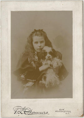
Pete Muldoon New Westminster Hockey Team Champions P.C.H.A.
- AM54-S4-: Sp P113.10
- Item
- 1912
Part of Major Matthews collection
Head and shoulders portrait
Pete Muldoon New Westminster Hockey Team Champions P.C.H.A.
Part of Major Matthews collection
Head and shoulders portrait
![Unloading salmon from the [sows], New Westminster, on line of C.P.R.](/uploads/r/null/f/0/b/f0b5ac529cc22e3b011d7faf1768c41f99b4fe887ae9ad0f12f42a5940129dae/73e59cf8-6932-4216-8f6b-78c3f83857f0-AM1052P-2180_142.jpg)
Unloading salmon from the [sows], New Westminster, on line of C.P.R.
Item is a postcard showing men unloading salmon on the docks at New Westminster. The back of the postcard includes personal correspondence addressed to Miss Jeannie Hurst.

Queen's Park, New Westminster, B.C.
Item is a postcard showing Queen's Park in New Westminster. The back of the postcard includes personal correspondence addressed to Miss Buhman.
![[First] May Day [Queen of the May celebration] New Westminster, B.C.](/uploads/r/null/e/a/eac8d3d29da4a019f1dce1518a1cf41c77c52bf7edd391ec5baaef49982b9fb3/120b048c-944b-4296-990b-3305cc884322-A32002_142.jpg)
[First] May Day [Queen of the May celebration] New Westminster, B.C.
Part of Major Matthews collection
Girl standing on fire engine is Helen McColl and man under Maypole with hands in pockets is Col. Scott
![[Second May Queen celebration at Queens Park, New Westminster]](/uploads/r/null/a/f/af64748c184c7a1c17036f5adced3b6a88e2d9cd43518beea9661c415191e496/97e8b9a3-dc0a-417d-a8ef-f891e9b0e67b-A32001_142.jpg)
[Second May Queen celebration at Queens Park, New Westminster]
Part of Major Matthews collection
People identified: Man in top hat: Col. Scott and two girls in front of Maypole (left): Helen McColl, (right): Elizabeth Irving

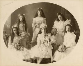
Aldyen Hamber crowning the May Queen at the 68th Annual May Day Celebration
Part of Hamber family fonds

The 68th Annual May Day Celebration
Part of Hamber family fonds

Crowd at unveiling of Simon Fraser monument
Part of Hamber family fonds

Part of Hamber family fonds

Part of Hamber family fonds

Margaret Wilson Hendry's casket and flowers
Part of Hamber family fonds
Part of Hamber family fonds

John, Adaline and Aldyen Hendry
Part of Hamber family fonds

Surprise party at John Hendry's
Part of Hamber family fonds
Part of Hamber family fonds

Part of Hamber family fonds


Native Sons of British Columbia Grand Post Meeting : New Westminster, B.C. : May 5th and 6th, 1927


Columbia Street New Westminster

Item is a photograph showing the bridge taken from Albert Crescent Park.

Carnegie Public Library New Westminster
Item is a photograph showing the former library building at 705 Carnarvon Street and a group of men working in the foreground.

Flowers, horses, painting Pattullo Bridge
Part of Douglas Stewart Scott fonds
Item is an amateur film which captures flowers, trees, and foliage, with the British Columbia Parliament buildings at times visible in the background; and women riding horses and playing with a dog. The latter half of the film captures labourers painting the Pattullo Bridge (New Westminster, B.C.) while hoisted on pulleys or simply free climbing. The workers, covered with paint themselves, pose together at the end of the film.
Part of Douglas Stewart Scott fonds
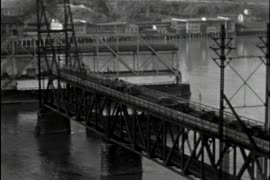
Item is an amateur film which captures shots of the New Westminster Bridge (also known as the Frasier River Swing Bridge) and the Pattullo Bridge. In the film, the swing mechanism of the New Westminster Bridge is shown as ships pass through, and the span then returns to allow the waiting vehicle traffic to pass. Following shots capture a man climbing on the underside of the through arch Pattullo Bridge.

Part of George Thompson fonds
Item is a film consisting of several amateur films that have been spliced together. The film documents at least eight different horse shows, races and rodeos. Some shows are identifiable, such as the Grand Horse Show & Gymkhana at Ambleside Park in West Vancouver and the Big-Horse Show at Queen's Park Stadium in New Westminster. The film includes footage of an indoor rodeo (possibly at the PNE) and numerous other unidentified shows at unknown racetracks and other locations, possibly in the Fraser Valley. Also included is footage of a farm and people grooming and riding horses.

Dial map of Greater Vancouver and suburbs
Part contains a street map of Vancouver, Burnaby, New Westminster, West Vancouver and North Vancouver showing block numbers, street car, bus, and railway lines, parks and hospitals. Map includes two dials (a numbered circle, a paper indicator, a grid of block numbers and a street index used to find locations). A small inset map shows the Capitol Hill/Scenic Park area of Burnaby in greater detail.

Part contains directions for using the dial map and the street index. Part includes Major Matthews's annotation that the map was "Presented, 23 Apr. 1942, by Robt. Morton, publisher, 2119 Maple St. aged 87."

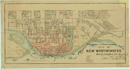
Dial map of New Westminster and Burnaby
Part contains a street map of New Westminster and Burnaby. Two small inset maps show the Capitol Hill/Scenic Park area and the area bounded by Canberra Avenue, Holdom Avenue, Dundas Street, and Hastings Street in greater detail.

Native Sons of British Columbia : Grand Post Meeting : May 5th and 6th, 1927
![[View of Columbia Street area after fire]](/uploads/r/null/1/b/1bd18fd212c8163ae7b005b28bf7a04b0ce908827725d8b4e90f73bdeeab550e/4737006e-762f-45f3-b080-ec516328b4d0-A09151_142.jpg)
[View of Columbia Street area after fire]
Part of Major Matthews collection
![[Bank of B.C. building after fire]](/uploads/r/null/8/f/8f796929afb216f3cf5863e5269a1aea7cfaa772400caa3765d99c07695d6ddc/3623b413-c431-4156-957f-c3c34fa9a7a8-A09150_142.jpg)
[Bank of B.C. building after fire]
Part of Major Matthews collection
Item is a photograph showing the ruined structure of the Bank of B.C. at Columbia and Sixth, New Westminster.

St. Peter's Church, New Westminster
Part of Robert Twizell fonds
Item is an architectural drawing depicting details of wood fittings.
Twizell & Twizell, Architects

New Westminster, B.C. - On the Fraser River
Item is a folder containing a set of paper panels printed with images of New Westminster. The folder also contains printed text, which is arranged in sections entitled "New Westminster and Agriculture," "New Westminster Industries," and "New Westminster - Features."
Item is a folder containing a set of paper panels printed with images of various sites in New Westminster. Two images are printed on the folder's cover.
![[Men making "Kus-kis" in camp at] New Westminster](/uploads/r/null/6/d/6dc02252100dd7f2571ffccda11a57b5243f1482e0f685223953c766c7dbb3ee/21e54e49-5a43-427b-a287-81bcef270429-A26497_142.jpg)
[Men making "Kus-kis" in camp at] New Westminster
Part of Major Matthews collection

Part of McQueen family fonds

Photographs of modular units at Royal Columbian Hospital, New Westminster B.C.
Contact sheet showing interior views of the prefabricated modular patient unit completed in 1971

Part of City of Vancouver fonds
Item is a map showing the railway line from New Westminster to Point Grey. Railway data appears to have been added to a base map showing topographic contour lines, shorelines, low tide marks, natural divides, and municipal boundaries.
Plan of system of sewerage for the city of New Westminster, British Columbia
Part of City of Vancouver Archives technical and cartographic drawing collection
Item is a published map of the City of New Westminster which has been annotated to depict a planned sewer system.
Hill, Albert J.

Part of City of Vancouver Archives technical and cartographic drawing collection
Map shows Hastings Town-site, Granville Town-site, Burnaby, and the City of New Westminster. Map also shows the Road from Granville and the False Creek Trail, as well as the names of places and soil types found along these roads. Other places and structures noted include Burrard Inlet, Coal Harbour (Coal Harbor on map), False Creek, False Creek Bridge, Burnaby Lake, Fraser River, New Westminster and Burrard Inlet Road, Douglas Road, Edinburgh Street, Columbia Street, Richards Street, and the New Westminster Cemetery. Two notes on map read "Plan to accompany Report of 1st May 1883, Joseph Hunter" and "Memo: Mr. Ross will place [?] this map to the [Engs.] Office Victoria [?]." 14T3 Roads & Trails is printed on the side of the map.
![[View of a New Westminster shipyard showing four wooden ships under construction]](/uploads/r/null/1/f/1fd6eb2d6a62a5c46ed8f270112ec63710993a0272308570f9534a83b3863e69/5386f8b2-e7e6-4b5d-bcaa-293f3ba94225-A63591_142.jpg)
[View of a New Westminster shipyard showing four wooden ships under construction]
Part of Major Matthews collection
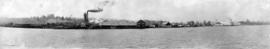
Brunette Sawmills, Ltd., Sapperton, B.C.
Part of Major Matthews collection
Panoramic view from the water

Brunette Sawmills, Ltd., Sapperton, B.C.
Part of Major Matthews collection
Panoramic view
![[Southward view of New Westminster showing Poplar Island]](/uploads/r/null/6/8/68173a634223d7486d4e195625533a4cf4add96456ecc410c5919ed97dd7946a/62efa34d-a0e4-4224-8b35-c363ae13e394-A63589_142.jpg)
[Southward view of New Westminster showing Poplar Island]
Part of Major Matthews collection
![[Exterior of Westminster Paper Co. Ltd.]](/uploads/r/null/b/f/bfde5657a4407502dc1fb4f4208875dfa95a6cde539d385de7ede8b2b03e3356/b81205cf-a58e-4ce3-8c9a-a91b54b5bc28-A63961_142.jpg)
[Exterior of Westminster Paper Co. Ltd.]
Part of Major Matthews collection
Photograph shows empty railroad flat bed cars in the foreground.
![[View from Vancouver Rowing Club at the foot of Thurlow Street]](/uploads/r/null/b/d/bda2af224b06e40e6801a2c57d563f0bb39cc7d923119d36e9db8d2a2c36cd52/32f7ca7d-4323-4c28-864f-1ea30262cb38-A64538_142.jpg)
[View from Vancouver Rowing Club at the foot of Thurlow Street]
Part of Major Matthews collection
Panoramic view showing a regatta, rowing races and a barge for spectators
![[Fraser River Bridge, New Westminster]](/uploads/r/null/a/c/ac30e2e12b5e4e4e963125b6ffbe7f5b4e10378003444290f976bc32f8d14882/b1847602-2800-4b32-88db-b4e8807e8f64-A04430_142.jpg)
[Fraser River Bridge, New Westminster]
Part of Major Matthews collection
J.S. Matthews' notes with print or negative in Archives.
![[Man sitting near destroyed buildings after New Westminster fire]](/uploads/r/null/b/9/b9b4a7c9d46dd658b0490f7e733eefb6c026f7b180bedead52617667deafe7c8/7d2d06e5-3c05-474e-9338-11ad12744c31-A04261_142.jpg)
[Man sitting near destroyed buildings after New Westminster fire]
Part of Major Matthews collection
J.S. Matthews' notes with print or negative in Archives.
![[Electrically powered canning machinery at B.C. Milk Condensing Co. Ltd.]](/uploads/r/null/e/3/e38b11f9d111f127491bda205d94c2b3d48041cfcafcd3d8aa270bb158fc5e75/5a7f0817-47f8-4d84-8531-8c2238108648-A08421_142.jpg)
[Electrically powered canning machinery at B.C. Milk Condensing Co. Ltd.]
Part of Major Matthews collection