
- AM1594-: MAP 235-: LEG1325.6
- Part
- 1888
Part of City of Vancouver Archives technical and cartographic drawing collection
Part contains information on Delta, Chilliwhack [sic], Surrey, New Westminster, Maple Ridge, Langley, and British Columbia.
18 results with digital objects Show results with digital objects
Part of City of Vancouver Archives technical and cartographic drawing collection
Part contains information on Delta, Chilliwhack [sic], Surrey, New Westminster, Maple Ridge, Langley, and British Columbia.

Dial map of Greater Vancouver and suburbs
Part of City of Vancouver Archives technical and cartographic drawing collection
Part contains a street map of Vancouver, Burnaby, New Westminster, West Vancouver, and North Vancouver showing railways, hospitals, parks and block numbers. The map includes two dials (numbered circles, paper indicators, a grid of block numbers and a street index used to find locations).

Dial map of Greater Vancouver and suburbs
Part of City of Vancouver Archives technical and cartographic drawing collection
Part contains a street map of Vancouver, Burnaby, New Westminster, West Vancouver and North Vancouver showing block numbers, street car, bus, and railway lines, parks and hospitals. Map includes two dials (a numbered circle, a paper indicator, a grid of block numbers and a street index used to find locations). A small inset map shows the Capitol Hill/Scenic Park area of Burnaby in greater detail.

Map of Burnaby and New Westminster, British Columbia
Part of City of Vancouver Archives technical and cartographic drawing collection
Part consists of a street map of Burnaby and New Westminster, information on bus and street car routes, and text advertising the products and services of the Dominion Map and Blueprint Company.

Map of downtown section of Vancouver ; Diagram of New Westminster, B.C., downtown section
Part of City of Vancouver Archives technical and cartographic drawing collection
Part contains road maps of downtown Vancouver and New Westminster, and textual information for tourists and motorists.

Map of downtown section of Vancouver ; Diagram of New Westminster, B.C., downtown section
Part of City of Vancouver Archives technical and cartographic drawing collection
Part contains road maps of downtown Vancouver and New Westminster, and textual information for tourists and motorists.

City of Vancouver : Canadian Pacific town site
Part of City of Vancouver Archives technical and cartographic drawing collection
Part contains four maps. The main map shows district lots and block numbers in Vancouver from Vine Street in the west to Boundary Avenue (Glen Drive) in the east and Stanley Park in the north to 9th Avenue (Broadway) in the south. Three smaller maps include an index plan to district lots in Vancouver, South Vancouver, New Westminster, and Burnaby; a world map showing Canadian Pacific mail steamship lines; and an index plan of Vancouver city limits.

Part of City of Vancouver Archives technical and cartographic drawing collection
Part contains a map showing street car, interurban, and motor bus lines in from Vancouver to New Westminster, a map showing existing and projected power plants near Alouette and Stave Lakes, and a profile showing the existing and proposed plants.

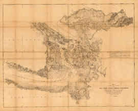
Geological map of parts of Nanaimo and New Westminster mining divisions
Part of City of Vancouver Archives technical and cartographic drawing collection
Item is a map showing Tertiary, Mesozoic, and Paleozoic areas and includes descriptive notes. Map drawn "To illustrate report by O. E. Leroy, M. Sc., 1906."
Map showing the line of boundary between the United States and British possessions
Part of City of Vancouver Archives technical and cartographic drawing collection
Item is a map showing four proposed boundaries between the United States and British possessions in the Salish Sea region. The explanations of the lines read in part: "[1] Boundary line contemplated by the Treaty as shown by contemporaneous evidence; [2] Boundary line as claimed by the British Commissioner; [3] Boundary line proposed by the British Commissioner as a compromise ( . . . ); [4] Boundary line in accordance with the strict letter of the Treaty ( . . . ). Item also shows soundings, and the "track of steamers plying between Victoria and Fraser river since discovery of gold."

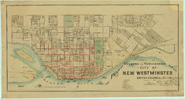
City of New Westminster British Columbia
Part of City of Vancouver Archives technical and cartographic drawing collection
Item is a map showing numbered lots in New Westminster between 10th Avenue and Columbia Street and between 20th Street and Sherbrooke Street. Streets, schools and parks are shown.

Map of the harbour of New Westminster, British Columbia
Part of City of Vancouver Archives technical and cartographic drawing collection
Item is a map showing the Fraser River and its North Arm as well as the Westminster Waterway surrounding New Westminster. A key map shows the location of New Westminster in relation to the Greater Vancouver area.
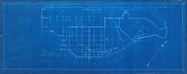
New Westminster waterworks : plan of city distribution system
Part of City of Vancouver Archives technical and cartographic drawing collection
Map shows New Westminster waterworks gates, hydrants, street and property boundaries, pipelines and divisions between high and low levels.

Plan of New Westminster City and suburban lots
Part of City of Vancouver Archives technical and cartographic drawing collection
Map shows land subdivisions and streets of New Westminster.

Dial map of Greater Vancouver and suburbs
Part of City of Vancouver Archives technical and cartographic drawing collection
Part contains a street map of Vancouver, Burnaby, New Westminster, West Vancouver and North Vancouver showing block numbers, street car, bus, and railway lines, parks and hospitals. Map includes two dials (a numbered circle, a paper indicator, a grid of block numbers and a street index used to find locations). A small inset map shows the Capitol Hill/Scenic Park area of Burnaby in greater detail.

Map of Vancouver, New Westminster, Steveston and the Lower Mainland District
Part of City of Vancouver Archives technical and cartographic drawing collection
Item is a map which shows major roads and C.P.R. lines in Vancouver, New Westminster, Steveston, and the Lower Mainland District. The map also shows sea routes and distances to various ports.

Part of City of Vancouver Archives technical and cartographic drawing collection
Map shows Hastings Town-site, Granville Town-site, Burnaby, and the City of New Westminster. Map also shows the Road from Granville and the False Creek Trail, as well as the names of places and soil types found along these roads. Other places and structures noted include Burrard Inlet, Coal Harbour (Coal Harbor on map), False Creek, False Creek Bridge, Burnaby Lake, Fraser River, New Westminster and Burrard Inlet Road, Douglas Road, Edinburgh Street, Columbia Street, Richards Street, and the New Westminster Cemetery. Two notes on map read "Plan to accompany Report of 1st May 1883, Joseph Hunter" and "Memo: Mr. Ross will place [?] this map to the [Engs.] Office Victoria [?]." 14T3 Roads & Trails is printed on the side of the map.
Plan of system of sewerage for the city of New Westminster, British Columbia
Part of City of Vancouver Archives technical and cartographic drawing collection
Item is a published map of the City of New Westminster which has been annotated to depict a planned sewer system.
Hill, Albert J.