- AM54-S4-: Trans N88.1
- Item
- [1898]
Part of Major Matthews collection
Part of Major Matthews collection

Part of Major Matthews collection
J.S. Matthews' notes with print or negative in Archives.

Columbia Street - Great Westmister Fire, Sept 11th, 1898
Part of Major Matthews collection
Photograph shows the ruins of buildings
![[View of Columbia Street]](/uploads/r/null/e/f/ef93d73651c288cd13bec183ae441b073bef56fd8e1478d1e8606db139c05f97/fffbb383-9d42-4db1-944b-a41bd8bd0042-A33175_142.jpg)
Part of Major Matthews collection

Columbia Street Great Westminster Fire
Part of Major Matthews collection

Columbia Street Great Westminster Fire
Part of Major Matthews collection
![[Columbia Street after the Great Fire]](/uploads/r/null/1/7/179957aacee335eed6e87456516082aa6e89bb97db37504c8f033e94eb0c05a6/d1cd8754-0693-48bd-9f28-8c8a5a8092aa-A33103_142.jpg)
[Columbia Street after the Great Fire]
Part of Major Matthews collection
![[View of Columbia Street from Begbie Street after the fire]](/uploads/r/null/9/e/9e4dec33bb4620d4856992e51992f5441b0d5a2697908885a9c9cfe45d5675d3/2002ab05-3851-4e5c-a3b2-4e70da6dcc47-A33028_142.jpg)
[View of Columbia Street from Begbie Street after the fire]
Part of Major Matthews collection
![Columbia Street [after the] Great Westminster Fire](/uploads/r/null/2/7/2708f676460b5fef7fc386e1f670494fbe18b76b0a790f9d1e65df4270b3c076/9c58892d-6ab7-4049-9c42-2e6308ce6682-A33937_142.jpg)
Columbia Street [after the] Great Westminster Fire
Part of Major Matthews collection
![[Men walking down] Columbia St., New Westminster [after fire of] Sept. 1898](/uploads/r/null/1/b/1b0f8051c619dd47fba03b78f9da32d37b7a382fb0d7c4f4dc80e58fc6ed40ff/50804529-08a4-4686-99b8-cf9572aa0687-A08675_142.jpg)
[Men walking down] Columbia St., New Westminster [after fire of] Sept. 1898
Part of Major Matthews collection
J.S. Matthews' notes with print or negative in Archives.
![Front St. from Lytton Sq. [after fire of September 10, 1898]](/uploads/r/null/0/3/0325a5cf8adf3cbfee425aef792e461732afb0973d9bb845393fe5d4d115c8ac/f81346df-1e11-45e6-ab08-79097eaaa408-A08674_142.jpg)
Front St. from Lytton Sq. [after fire of September 10, 1898]
Part of Major Matthews collection
J.S. Matthews' notes with print or negative in Archives.
![Looking down Columbia St. from top of Burr block [after fire of September 10, 1898]](/uploads/r/null/3/5/3508071c7b441a9b8b364078f37d3c2a836c36a7f8ba7cfc9861042091cba91d/86f4a42e-9688-4f9c-b38c-cdf51ca84027-A08672_142.jpg)
Looking down Columbia St. from top of Burr block [after fire of September 10, 1898]
Part of Major Matthews collection
J.S. Matthews' notes with print or negative in Archives.
![[Celebrating "The Relief of Ladysmith, South Africa" on Columbia Street]](/uploads/r/null/2/4/2477fd876c37d6c77a8bcd3c5ab53754f444a4a9d270d53215637770fb1265e4/0a558fc1-e73a-4e26-9908-3c02ada67341-A32316_142.jpg)
[Celebrating "The Relief of Ladysmith, South Africa" on Columbia Street]
Part of Major Matthews collection

Part of City of Vancouver Archives technical and cartographic drawing collection
Map shows Hastings Town-site, Granville Town-site, Burnaby, and the City of New Westminster. Map also shows the Road from Granville and the False Creek Trail, as well as the names of places and soil types found along these roads. Other places and structures noted include Burrard Inlet, Coal Harbour (Coal Harbor on map), False Creek, False Creek Bridge, Burnaby Lake, Fraser River, New Westminster and Burrard Inlet Road, Douglas Road, Edinburgh Street, Columbia Street, Richards Street, and the New Westminster Cemetery. Two notes on map read "Plan to accompany Report of 1st May 1883, Joseph Hunter" and "Memo: Mr. Ross will place [?] this map to the [Engs.] Office Victoria [?]." 14T3 Roads & Trails is printed on the side of the map.

Part of Major Matthews collection

Map of downtown section of Vancouver ; Diagram of New Westminster, B.C., downtown section
Part of City of Vancouver Archives technical and cartographic drawing collection
Part contains road maps of downtown Vancouver and New Westminster, and textual information for tourists and motorists.

Dial map of Greater Vancouver and suburbs
Part contains a street map of Vancouver, Burnaby, New Westminster, West Vancouver and North Vancouver showing block numbers, street car, bus, and railway lines, parks and hospitals. Map includes two dials (a numbered circle, a paper indicator, a grid of block numbers and a street index used to find locations). A small inset map shows the Capitol Hill/Scenic Park area of Burnaby in greater detail.

Part contains directions for using the dial map and the street index. Part includes Major Matthews's annotation that the map was "Presented, 23 Apr. 1942, by Robt. Morton, publisher, 2119 Maple St. aged 87."

Dial map of New Westminster and Burnaby
Part contains a street map of New Westminster and Burnaby. Two small inset maps show the Capitol Hill/Scenic Park area and the area bounded by Canberra Avenue, Holdom Avenue, Dundas Street, and Hastings Street in greater detail.

Dial map of Greater Vancouver and suburbs
Part of City of Vancouver Archives technical and cartographic drawing collection
Part contains a street map of Vancouver, Burnaby, New Westminster, West Vancouver and North Vancouver showing block numbers, street car, bus, and railway lines, parks and hospitals. Map includes two dials (a numbered circle, a paper indicator, a grid of block numbers and a street index used to find locations). A small inset map shows the Capitol Hill/Scenic Park area of Burnaby in greater detail.

Map of Burnaby and New Westminster, British Columbia
Part of City of Vancouver Archives technical and cartographic drawing collection
Part consists of a street map of Burnaby and New Westminster, information on bus and street car routes, and text advertising the products and services of the Dominion Map and Blueprint Company.

Dial map of Greater Vancouver and suburbs
Part of City of Vancouver Archives technical and cartographic drawing collection
Part contains a street map of Vancouver, Burnaby, New Westminster, West Vancouver, and North Vancouver showing railways, hospitals, parks and block numbers. The map includes two dials (numbered circles, paper indicators, a grid of block numbers and a street index used to find locations).

Transit detail inset maps ; Street index ; Transit and tourist information
Part consists of three maps showing transit details in Richmond, New Westminster and downtown Vancouver, and descriptive information about B.C. Electric routes and services and Greater Vancouver attractions.

Map of Fraser Valley ; Street map of New Westminster ; Map of Greater Vancouver transit lines
Part consists of a street map of the Lower Mainland and Fraser Valley from Vancouver to Chilliwack, a street map of New Westminster, a map showing transit lines in Greater Vancouver, and text advertising the products and services of the Dominion Map and Blueprint Company.

Part consists of a street map of the Lower Mainland and Fraser Valley from Vancouver to Chilliwack, a street map of New Westminster, a map of Vancouver and North Vancouver showing street names but not street lines, and text advertising the products and services of the Dominion Map and Blueprint Company.

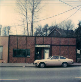
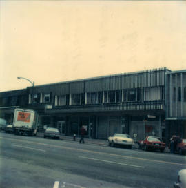
Paper Chase business can be seen.
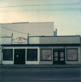
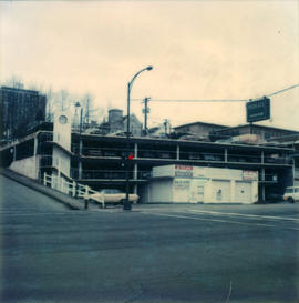
CCC Ventures sign can be seen.

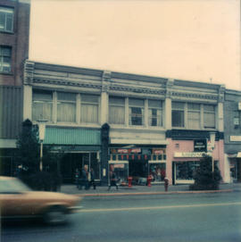
Radio Shack and Tandy Leathercraft businesses can be seen.

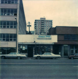
Kennedy Travel can be seen.

The Mercantile Building, 332 Columbia, can be seen.
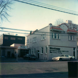
Sign for Westamp rubber stamp company can be seen.


King Edward Hotel


Sign for Wharfside Craft Centre can be seen.
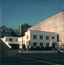
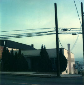
Sign for Columbia Funeral Chapel can be seen.