
- COV-S371-: MAP 367-: LEG1336.41
- Part
- [1912 or 1913]
Part of City of Vancouver fonds
132 results with digital objects Show results with digital objects
Part of City of Vancouver fonds

Part of City of Vancouver fonds

Part of City of Vancouver fonds

Part of City of Vancouver fonds

Part of City of Vancouver fonds

Part of City of Vancouver fonds

Part of City of Vancouver fonds

Part of City of Vancouver fonds

Part of City of Vancouver fonds

Part of City of Vancouver fonds

Part of City of Vancouver fonds

Part of City of Vancouver fonds

Part of City of Vancouver fonds

Part of City of Vancouver fonds

Part of City of Vancouver fonds

Part of City of Vancouver fonds

Part of City of Vancouver fonds

Part of City of Vancouver fonds

Part of City of Vancouver fonds

Part of City of Vancouver fonds

Part of City of Vancouver fonds

Part of City of Vancouver fonds

Part of City of Vancouver fonds

Part of City of Vancouver fonds

Part of City of Vancouver fonds
Part of City of Vancouver fonds

Part of City of Vancouver fonds

Part of City of Vancouver fonds

Part of City of Vancouver fonds

Part of City of Vancouver fonds

Part of City of Vancouver fonds

Part of City of Vancouver fonds
Part of City of Vancouver fonds

Part of City of Vancouver fonds

Part of City of Vancouver fonds

Part of City of Vancouver fonds

Part of City of Vancouver fonds
Part of City of Vancouver fonds

Part of City of Vancouver fonds

Part of City of Vancouver fonds

Part of City of Vancouver fonds

City of Vancouver : Canadian Pacific town site
Part of City of Vancouver Archives technical and cartographic drawing collection
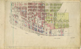
Part contains four maps. The main map shows district lots and block numbers in Vancouver from Vine Street in the west to Boundary Avenue (Glen Drive) in the east and Stanley Park in the north to 9th Avenue (Broadway) in the south. Three smaller maps include an index plan to district lots in Vancouver, South Vancouver, New Westminster, and Burnaby; a world map showing Canadian Pacific mail steamship lines; and an index plan of Vancouver city limits.

Part of City of Vancouver fonds
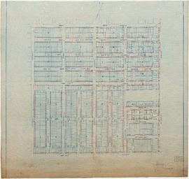
Part is a section depicting the area bounded by Boundary Road to Sixty-fifth Avenue to Vivian Street to the Fraser River. The sheet has been extensively annotated, with colour coded areas to depict land use, status of lots as tax sale properties for sale, sewer and water lines, as well as other colour codes that are not noted on the legend at the front of the volume.
Part of City of Vancouver fonds
Part is a section depicting the area bounded by Vivian Street to Sixty-second Avenue to Argyle Street to the Fraser River. The sheet has been extensively annotated, with colour coded areas to depict land use, status of lots as tax sale properties for sale, sewer and water lines, as well as other colour codes that are not noted on the legend at the front of the volume.

South Vancouver section 17 supplementary information
Part of City of Vancouver fonds
Part is a sheet showing assessment and other information relevant to South Vancouver section 17.

Part of City of Vancouver fonds
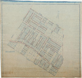
Part is a section depicting the area bounded by Argyle Street to Fifty-eighth Avenue to St. George Street to the Fraser River. The sheet has been extensively annotated, with colour coded areas to depict land use, status of lots as tax sale properties for sale, sewer and water lines, as well as other colour codes that are not noted on the legend at the front of the volume.

South Vancouver section 16 supplementary information
Part of City of Vancouver fonds
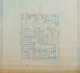
Part is a sheet showing assessment and other information relevant to South Vancouver section 16. The sheet also includes two attached overlays depicting block revisions in the following areas: the blocks immediately east of Dumfries Street between 57th Avenue and 59th Avenue; and the lots on the west side of Fraser Street between 59th Avenue and 60th Avenue.

Part of City of Vancouver fonds
Part is a section depicting the area bounded by St. George Street to Fifty-ninth Avenue to Ash Street to the Vancouer and Lulu Island railway right-of-way. Note that this sheet overlaps the are covered by South Vancouver sheet 14. The sheet has been extensively annotated, with colour coded areas to depict land use, status of lots as tax sale properties for sale, sewer and water lines, as well as other colour codes that are not noted on the legend at the front of the volume.

South Vancouver section 15 supplementary information-2
Part of City of Vancouver fonds
Part is an overlay taped over top of one of the overlays on sheet LEG1153.465.113. This second lyaer of overlay depicts lot renumbering in the block of 63rd Avenue east of Ontario Street.

South Vancouver section 15 supplementary information-1
Part of City of Vancouver fonds
Part is a sheet showing assessment and other information relevant to South Vancouver section 15. The sheet also includes four attached overlays depicting block revisions in the following areas: the bock on the east side of Main Street between 62nd Avenue and 63rd Avenue; the block on the east side of Cambie Street between Marine Drive and 65th Avenue; lots along 60th Avenue and 61st Avenue between St. George Street and Prince Edward Street; and the block bounded by Prince Edward Street, 61st Avenue, Main Street and 62nd Avenue.