Print preview Close
Showing 79 results
Archival description78 results with digital objects Show results with digital objects
![[View of Cedar Cottage Road (Commercial Street) at the B.C.E.R. tracks at18th Avenue]](/uploads/r/null/c/e/ce59d93d446113ad663f487043aa0290516ae51fd4f8e3b5edd38c1e439e1256/311cf77c-bd71-4a2c-b7d4-c2e32e684736-A61086_142.jpg)
[View of Cedar Cottage Road (Commercial Street) at the B.C.E.R. tracks at18th Avenue]
![Boundary Road and Park Avenue [Vanness Street] Station](/uploads/r/null/7/4/5/7454a742bd98a374f4d947f025601d8fb773a9d430b79f0ede14ce9844527c3b/c746218c-84b8-4d56-8a01-01c1c07d955c-CVA371-818_142.jpg)
Boundary Road and Park Avenue [Vanness Street] Station
![Boundary Road and Park Avenue [Vanness Street] Station](/uploads/r/null/1/5/158b957e2f59bf46258a58be7442e2890bfe702e8ed04418b64c917a83c29e26/ee14a5f7-6c67-40c8-931b-4dc21bcddcdd-A37339_142.jpg)
Boundary Road and Park Avenue [Vanness Street] Station
![[Houses in South Vancouver]](/uploads/r/null/9/6/96beb114cdd36eb0925112d2fd5239b964d9de446cf79bd3c538c89ef082f0b8/090fc4d6-bd26-46bc-835f-1b2282ac15df-A19300_142.jpg)
[Houses in South Vancouver]
![[Street car outside the Winram Block, 17th and Main St.]](/uploads/r/null/e/1/e14e644a588b3f93678f4c964d20100150b12ddfe3bf74e33850981e29b76c8b/a52e4081-8f51-4943-a4c5-3fadd9085e6b-A19271_142.jpg)
[Street car outside the Winram Block, 17th and Main St.]
![[View of 33rd Avenue showing road work in progress]](/uploads/r/null/b/3/b3d6aa7eb8fb0bf11bef829f4930510c09435ec0ead8048f44cfbf1708600abf/b1595b8e-b135-4c1d-a4e8-8737f2850cd0-A19297_142.jpg)
[View of 33rd Avenue showing road work in progress]
![[View of a dirt road, possibly 33rd Avenue, with street car tracks along one side]](/uploads/r/null/c/6/c64e9d504cc9b533bf0c5d0399db85273e1137fd7e3945aa2e84aa82a215b053/db19eae9-2562-40d9-9249-b36cc0c36f0b-A19282_142.jpg)
[View of a dirt road, possibly 33rd Avenue, with street car tracks along one side]
![[View of the] Main St. bog [between 33rd Avenue and 41st Avenue]](/uploads/r/null/7/f/7fb80b09ebfd64e91e42bdfb033c7901f4187e4e47fb8a675f55ecce664255be/0d0df890-2794-44d1-b878-b21f154e60b1-A19256_142.jpg)
[View of the] Main St. bog [between 33rd Avenue and 41st Avenue]
![[View of] 56th Avenue](/uploads/r/null/5/e/5e6e63808539d76e2bb1611fb7f58e19d6ff2f5c79c8c0fb9a41ae096f1041e3/c876d1dc-483f-4911-be0a-4ea8219a7537-A19232_142.jpg)
[View of] 56th Avenue
![[Horse and cart travelling along] 34th Avenue [now 33rd Ave.] before paving](/uploads/r/null/1/b/1bea09e65d46b4109283423d33373961bada71fdd08bf41e25c639f1387eb3a6/ec202a7a-9fdb-4901-9fe9-d5885081dc3d-A19285_142.jpg)
[Horse and cart travelling along] 34th Avenue [now 33rd Ave.] before paving
![[View of an intersection on Kingsway]](/uploads/r/null/c/f/cfe400afd470037c32921b61c3e288beb498141a4ed40bba8a293220e8bfdf44/71808117-63ec-4d3d-a3fc-57f737009105-A19334_142.jpg)
[View of an intersection on Kingsway]
![[View of intersection probably River Avenue, now Marine Drive, and Fraser Street]](/uploads/r/null/6/4/6452707075abe1664e358d730eaeb4c51f71f6ce92a5dd0e0f63dfe4efc6b183/2af5de23-d671-4a66-bcb0-386ae624da78-A19355_142.jpg)
[View of intersection probably River Avenue, now Marine Drive, and Fraser Street]
![[View of road paving at the] Intersection Main St. and 34th Ave. [now 33rd Avenue]](/uploads/r/null/e/b/eb7cbb6633178207f5f6cba577f32455439dead88a072ac334180ac063701e1a/ee3c2d88-476a-4a4c-b0c8-13120cd63792-A19287_142.jpg)
[View of road paving at the] Intersection Main St. and 34th Ave. [now 33rd Avenue]
![[View of] 34th Ave [now 33rd Ave] showing bitulithic paving](/uploads/r/null/1/5/15414121a12f5fa073fca9e2c5389404bfae71a44dd49b8a52e6efc7ea4096d9/38ff3049-ffb8-490e-ba3d-9b6da6192256-A19286_142.jpg)
[View of] 34th Ave [now 33rd Ave] showing bitulithic paving
![Finished bitulithic pavement Fraser St. and 34th Ave. [now 33rd Ave.]](/uploads/r/null/c/e/ced8cd4412754133f7d8b463ccd8ac13af0a8edf3f6aa85b1badc6e4af86de92/2bf50e3c-64a8-4efa-b475-59422ab6f306-A19292_142.jpg)
Finished bitulithic pavement Fraser St. and 34th Ave. [now 33rd Ave.]
![[Horse and cart travelling along 34th Avenue (now 33rd Avenue) before paving]](/uploads/r/null/5/8/58accbe9066b3a5afac554e1ad18cdf02097c9d7ed41cdcb5fd1f274eecd26dd/9e97a0b1-fb21-43e0-bdb6-846e105fa9f6-A19268_142.jpg)
[Horse and cart travelling along 34th Avenue (now 33rd Avenue) before paving]
![[Surveyors on street in South Vancouver]](/uploads/r/null/b/0/b09502a2af3b99222d80fd5668c89eb6ad7f009934c53dd430cadad418ffe532/5b53049e-48db-4876-9ec4-b4adcbb0e6e0-A19303_142.jpg)
[Surveyors on street in South Vancouver]
![[View of Joyce Street looking south west towards Carleton School]](/uploads/r/null/6/5/65fddfb53fec807e9ed3476cea8eed909270066ae00a0cc4c69987f1c05de56e/5da90945-5972-46b9-8b35-bd078632aec3-A19313_142.jpg)
[View of Joyce Street looking south west towards Carleton School]
![[View of finished] Paving Main St. and 17th Ave. looking north [showing the Winram block]](/uploads/r/null/5/b/5bac016b96314bbeb917b4e377d1ee1841c46536089bb447fecfdd79e090d3ee/b572beb9-fb07-4eb5-bda9-9431a294e603-A19258_142.jpg)
[View of finished] Paving Main St. and 17th Ave. looking north [showing the Winram block]
![[View of] Main St. and 51st Ave. looking north](/uploads/r/null/f/8/f883edec5ff5f43b5a87451c288ebdd8ac155bbc70a6da73860b2397d6cd3d41/ba858f93-e41e-4f01-b6e1-113768409322-A19260_142.jpg)
[View of] Main St. and 51st Ave. looking north
![[View of Main Street looking north from about 64th Avenue]](/uploads/r/null/a/7/a731d8302c523c6979f46e7674ec30b321dcb3566a777e687c30268e03a6d0ca/2bcbccc2-7bc7-48f4-a4a8-bbafd71760c3-A37088_142.jpg)
[View of Main Street looking north from about 64th Avenue]
![[Looking north from Kingsway at Joyce Road (Street)]](/uploads/r/null/5/4/54da2c7ede6039c5ec882ae8f4244c0a549f175dec50cf7a39402b7f5608511e/bd288290-b957-49b5-b2a1-da73bb7c7379-A62737_142.jpg)
[Looking north from Kingsway at Joyce Road (Street)]
![[View of streetcar, automobile, and businesses at] 25th and Fraser Avenue. S[outh] Vancouver, B.C.](/uploads/r/null/9/0/901e8753c8b56d423c574b4d67cb84c95748fc6eca91b25bb09f09dfd40eecc6/92a75128-a994-4238-8f0a-cbc46c8ab828-A04451_142.jpg)
[View of streetcar, automobile, and businesses at] 25th and Fraser Avenue. S[outh] Vancouver, B.C.
![[People entering streetcar on Main Street at 25th Avenue]](/uploads/r/null/7/3/73e5b03273a4342e33703d759e95195f161d4b05b3c73be4d76ba5118bebd463/d73b91e1-7630-459f-ae97-2cd75375f37e-A04880_142.jpg)
[People entering streetcar on Main Street at 25th Avenue]
Water service map of South Vancouver
Water service map of South Vancouver

Water service map of South Vancouver : Ontario Street to Fraser Street and King Edward Avenue to 34th Avenue (33rd Avenue)

Water service map of South Vancouver : Victoria Drive to Wales Street and 35th Avenue (34th Avenue) to 46th Avenue (45th Avenue)

Water service map of South Vancouver : Fraser Street to Sherbrooke Street and 43rd Avenue (41st Avenue) to 51st Avenue (49th Avenue)

Water service map of South Vancouver : Kerr Street to Tyne Street and 46th Avenue (45th Avenue) to 56th Avenue (54th Avenue)

Water service map of South Vancouver : Victoria Drive to Vivian Street and 56th Avenue (54th Avenue) to 67th Avenue (65th Avenue)

Water service map of South Vancouver : Kerr Street to Tyne Street and 56th Avenue (54th Avenue) to 67th Avenue (65th Avenue)
![Main St. and 17th Ave. [looking north]](/uploads/r/null/b/3/b3380bb884ee7a8abac63dac3db8e22d0e65982e440c0d9e7a43832360b0b9d2/ef766592-a7b5-4c13-8b42-c6fa72ea48d5-A04458_142.jpg)
Main St. and 17th Ave. [looking north]
![Main St. and 25th Ave. [looking south] Vancouver, B.C.](/uploads/r/null/0/8/08cfe09cabe09306b4abcdd0bbc671968ca95776880ab30e7dc4752ee802122d/bedd2e3b-3c6e-4604-a77f-d2e59229a971-A04454_142.jpg)
Main St. and 25th Ave. [looking south] Vancouver, B.C.
![[View of streetcar and businesses at] 49th and Fraser Aves. S[outh] Vancouver](/uploads/r/null/5/7/576330d6b9b9241916a75cabbb1b0f4006e91e6fa5e73dc92d69ed96e9d4b816/e8274e7d-e6c9-447a-80f1-7dda03a6d63f-A04452_142.jpg)
[View of streetcar and businesses at] 49th and Fraser Aves. S[outh] Vancouver
Water service map of South Vancouver : Knight Street to Commercial Street and 15th Avenue (16th Avenue) to 22nd Avenue

Water service map of South Vancouver : Knight Street to Victoria Drive and 22nd Avenue to 34th Ave (33rd Avenue)

Water service map of South Vancouver : Vivian Street to Kerr Street and 46th Avenue (45th Avenue) to 56th Avenue (54th Avenue)

Water service map of South Vancouver : Fraser Street to Knight Street and 51st Avenue (49th Avenue) to 61st Avenue (59th Avenue)

Water service map of South Vancouver : Vivian Street to Kerr Street and 56th Avenue (54th Avenue) to 67th Avenue (65th Avenue)

Water service map of South Vancouver : Knight Street to Victoria Drive and 61st Avenue (59th Avenue) to North Arm of Fraser River

Water service map of South Vancouver : Victoria Drive to Vivian Street and 46th Avenue (45th Avenue) to 56th Avenue (54th Avenue)

Water service map of South Vancouver : Knight Street to Victoria Drive and 51st Avenue (49th Avenue) to 61st Avenue (59th Avenue)

Water service map of South Vancouver : Tyne Street to Park Street (Boundary Road) and 56th Avenue (54th Avenue) to 67th Avenue (65th Avenue)

Water service map of South Vancouver : Vivian Street to Doman Street and 67th Avenue (65th Avenue) to North Arm of Fraser River
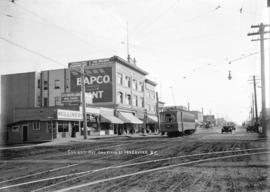
Corner 25th Avenue and Main Street, Vancouver, B.C.

Water service map of South Vancouver : Bridge Street (Cambie Street) to Main Street and 16th Avenue to 26th Avenue

Water service map of South Vancouver : Fraser Street to Knight Street and 25th Avenue to 34th Avenue (33rd Avenue)

Water service map of South Vancouver : Tyne Street to Park Street (Boundary Road) and 46th Avenue (45th Avenue) to 56th Avenue (54th Avenue)

Water service map of South Vancouver : Victoria Drive to Vivan Street and 67th Avenue (65th Avenue) to North Arm of Fraser River

Water service map of South Vancouver : Doman Street to Park Street (Boundary Road) and 67th Avenue (65th Avenue) to North Arm of Fraser River
Results 1 to 50 of 79