
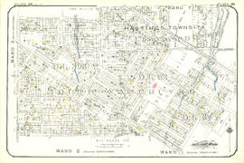
- AM1594-: MAP 13
- Item
- [between 1900 and 1929
Part of City of Vancouver Archives technical and cartographic drawing collection
45 results with digital objects Show results with digital objects
Part of City of Vancouver Archives technical and cartographic drawing collection

Plan of subdivision of part of D.L. 526 : South Vancouver
Part of City of Vancouver Archives technical and cartographic drawing collection
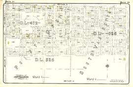
Item is a map denoting Canadian Pacific land in D.L. 526. The map shows blocks 581-584, 601-604, 621-624, 661-664, 681-684 bounded on the north by 20th Ave., south by McMullen Ave., east by Ontario Street, and west by Bridge Street.

Index plan of provincial government lands to be sold at auction at Vancouver B.C. November 20, 1906
Part of City of Vancouver Archives technical and cartographic drawing collection
Item is a map showing lots owned by the provincial government to be sold at auction. Lots are located in North Vancouver, Vancouver, South Vancouver, Hastings Townsite and Burnaby.

Plan of part of subdivision of district lot 540. South Vancouver
Part of City of Vancouver Archives technical and cartographic drawing collection
Item is a map showing provincially-owned properties for sale in District Lot 540, South Vancouver, B.C.

City of Vancouver : Canadian Pacific town site
Part of City of Vancouver Archives technical and cartographic drawing collection
Part contains four maps. The main map shows district lots and block numbers in Vancouver from Vine Street in the west to Boundary Avenue (Glen Drive) in the east and Stanley Park in the north to 9th Avenue (Broadway) in the south. Three smaller maps include an index plan to district lots in Vancouver, South Vancouver, New Westminster, and Burnaby; a world map showing Canadian Pacific mail steamship lines; and an index plan of Vancouver city limits.

Vancouver City : plan of Subdivision of lot 301, Group 1, New Westminster District
Part of City of Vancouver Archives technical and cartographic drawing collection
The map shows the subdivision of lots in the boundary area of Vancouver and South Vancouver, around the current areas of Mount Pleasant and Grandview.

Municipality of South Vancouver
Part of City of Vancouver Archives technical and cartographic drawing collection
Item is a map sheet; the main map shows District Lots, blocks and lots, street addresses, schools, and a cemetery. The inset map shows electric streetcar lines in from Vancouver to New Westminster.
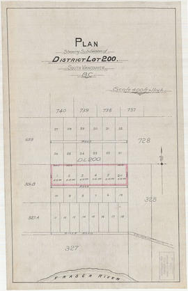
Plan shewing subdivision of District Lot 200. South Vancouver, B.C.
Part of City of Vancouver Archives technical and cartographic drawing collection
Item is a map depicting a planned subdivisions of District Lot 200, located near River Road. Surrounding District Lots are also shown.

Municipality of South Vancouver
Part of City of Vancouver Archives technical and cartographic drawing collection
Item is a map showing legal addresses, streets and schools in South Vancouver. A small key plan shows the location of the area covered by the primary map in relation to the rest of the Lower Mainland.

The Municipality of South Vancouver
Part of City of Vancouver Archives technical and cartographic drawing collection
Item is a map depicting the Municipality of South Vancouver. The map has been annotated to indicate some of the routes of BC Electric Railway street car lines and surveyed extensions.
![Plan of re-subdivision of lots 3 to 14, subn [subdivision] 2 of bk [block] 3. D.L. 391 & 392](/uploads/r/null/4/a/4a0ea6aa076433c7bcad0c847f7acb3bb1046f7abf2801c48b97d9ca58f49a73/9bd508e4-c85e-4090-b266-27571c5d4dbc-MAP754_142.jpg)
Plan of re-subdivision of lots 3 to 14, subn [subdivision] 2 of bk [block] 3. D.L. 391 & 392
Part of City of Vancouver Archives technical and cartographic drawing collection
Map shows the subdivision of lots in the block bordered by 31st Avenue East, 32nd Avenue East, St. Catherines Street and Windsor Street, at that time in the District of South Vancouver. Map is certified by the surveyor Arthur H. Holland, British Columbia Land Surveyor, and W.A. Pound, Reeve of the District of South Vancouver. It is unclear as to whether the map was commissioned by the Corporation of the District of South Vancouver.

Vancouver, British Columbia, south-easterly portion, formerly South Vancouver : major street plan
Part of City of Vancouver Archives technical and cartographic drawing collection
Item is a map which has been removed from a copy of the report "A plan for the City of Vancouver, British Columbia, including Point Grey and South Vancouver and a general plan of the region", commissioned by the Vancouver Town Planning Commission from the planning consultants Harland Bartholomew & Associates.
The map shows major streets of sufficient width, major streets to be widened, new major street connections, present street widths, present lines of vehicles, present roadway widths, proposed street widths, proposed lines of vehicles, proposed roadway widths and pleasure drives in the area of the former Municipality of South Vancouver.
Harland Bartholomew and Associates
![Plan shewing [showing] division of property belonging to Major C.W. Hill](/uploads/r/null/0/f/0f72067c788c91a520f5055e8b1241e0ee99f2c20c434b03eca0174baea425dc/d22e8a25-814f-4266-99a4-24c639764600-MAP787_142.jpg)
Plan shewing [showing] division of property belonging to Major C.W. Hill
Part of City of Vancouver Archives technical and cartographic drawing collection
Item is a sketch plan of an area in South Vancouver encompassing Argyle Street, Harrison Avenue and Gritton Avenue. Plan shows the division of property belonging to Major C.W. Hill. The name of the person to which land was deeded and sometimes the date and the price paid is written on each lot.

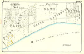
Municipality of South Vancouver
Part of City of Vancouver Archives technical and cartographic drawing collection
Item is a map showing district lot, block and some lot numbers, wards, electric railways and some street names in the Municipality of South Vancouver.
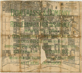
Part of City of Vancouver Archives technical and cartographic drawing collection
Item is a map used as an advertisement for Dow, Fraser & Co. Limited, Real Estate and Fire Insurance. The map portion of the design is taken from a map published by Archibald Moir & Co. (see MAP 73).

Plan of the municipality of South Vancouver
Part of City of Vancouver Archives technical and cartographic drawing collection
Item is a map showing streets, lot numbers and lot boundaries in the municipality of South Vancouver.
![Plate 28: Fairview [Ontario Street - Broadway/Ninth Avenue - Oak Street - Nineteenth Avenue]](/uploads/r/null/7/e/6/7e62aa80c58481466edbc9d0d7b745c557d25fdf62d02e52fa8c3f1cf37aff45/4bea1d2d-ba54-43ec-a23e-ba0cbb34f094-MAP342a_142.jpg)
Plate 28: Fairview [Ontario Street - Broadway/Ninth Avenue - Oak Street - Nineteenth Avenue]
Part of City of Vancouver Archives technical and cartographic drawing collection
Item is a map depicting an area bounded by the following streets: Ontario Street (west side only) to Broadway/Ninth Avenue West (south side only) to Oak Street (east side only) to Nineteenth Avenue West (north side only).
Part of City of Vancouver Archives technical and cartographic drawing collection
Item is a map depicting an area bounded by the following streets: Ontario Street (west side only) to Nineteenth Avenue West (south side only) to Oak Street (east side only) to Twenty-sixth Avenue/Twenty-fifth Avenue (north side only) and north part of District Lot 526.

Part of City of Vancouver Archives technical and cartographic drawing collection
Item is a map depicting an area bounded by the following streets: Ontario Street (west side only) to Twenty-ninth Avenue to Oak Street (east side only) to approximate location of current West 39th Avenue.

Part of City of Vancouver Archives technical and cartographic drawing collection
Item is a map depicting an area bounded by the following streets: Ontario Street to appoximate location of modern West 39th Avenue to Oak Street to Forty-ninth Avenue (Point Grey)/Fifty-first Avenue (South Vancouver).

Part of City of Vancouver Archives technical and cartographic drawing collection
Item is a map depicting an area bounded by the following streets: Ontario Street to Essex Street/Sixty-first Avenue West to Fremlin Avenue to Townsend Road [now West 70th Avenue].
Part of City of Vancouver Archives technical and cartographic drawing collection
Item is a map depicting an area bounded by the following streets: Ontario Street (west side only) to approximate location of modern West 69th Avenue to Fremlin Avenue to the Fraser River.
![Plate 90: Mount Pleasant [Dock Street - Fifteenth Avenue - Ontario Street - King Edward Avenue]](/uploads/r/null/1/4/a/14a723151dc29add34dd378781a27b78829657362f3dce469dffb0c264f8b9e6/1f2977a4-639f-4884-9997-fe2cfc8e0113-MAP342b_142.jpg)
Plate 90: Mount Pleasant [Dock Street - Fifteenth Avenue - Ontario Street - King Edward Avenue]
Part of City of Vancouver Archives technical and cartographic drawing collection
Item is a map depicting an area bounded by the following streets: Dock Street (now Windsor Street) (west side only) to Fifteenth Avenue East (south side only) to Ontario Street (east side only) to King Edward Avenue (north side only).
![Plate 91: Cedar Cottage [Victoria Drive - Fifteenth Avenue - Dock Street - Twenty-sixth Avenue]](/uploads/r/null/2/1/7/217edd89cad278dfc0bd1fc7e39c6e94ef810a749dcc25df6d8cf20b62aef543/eb359274-1a75-470b-8ae5-ec198732f39e-MAP342b_142.jpg)
Plate 91: Cedar Cottage [Victoria Drive - Fifteenth Avenue - Dock Street - Twenty-sixth Avenue]
Part of City of Vancouver Archives technical and cartographic drawing collection
Item is a map depicting an area bounded by the following streets: Victoria Drive (west wide only) to Fifteenth Avenue East (south side only) to Dock Street (now Windsor Street) (east side only) to Twenty-sixth Avenue East (north side only).
![Plate 92: Cedar Cottage [Renfrew Street - Fifteenth Avenue - Victoria Drive - Twenty-seventh Avenue]](/uploads/r/null/a/b/b/abb7f25c911ce6ce2413a2bddb9e4d31d20604606dc24aa9fe3c57f738b558ed/5cb54521-8a89-4c87-aa94-ddbf1ded377e-MAP342b_142.jpg)
Plate 92: Cedar Cottage [Renfrew Street - Fifteenth Avenue - Victoria Drive - Twenty-seventh Avenue]
Part of City of Vancouver Archives technical and cartographic drawing collection
Item is a map depicting an area bounded by the following streets: Renfrew Street (west side only) to Fifteenth Avenue East (south side only) to Victoria Drive (east side only south of Twentieth Avenue East) to Twenty-seventh Avenue East (north side only).
![Plate 94: Kensington [Windsor Street - King Edward Avenue - Ontario Street - Thirty-sixth Avenue]](/uploads/r/null/2/1/2/21289f7c15f79622dff7045fda88900f7c1945ee2e9cb9057fba0e68653b7818/3bbf66d1-de75-4d89-bcfb-21ba4173ebff-MAP342b_142.jpg)
Plate 94: Kensington [Windsor Street - King Edward Avenue - Ontario Street - Thirty-sixth Avenue]
Part of City of Vancouver Archives technical and cartographic drawing collection
Item is a map depicting an area bounded by the following streets: Windsor Street (west side only) to King Edward Avenue East (south side only) to Ontario Street (east side only) to Thirty-sixth Avenue (north side only).
![Plate 95: Kensington [Victoria Drive - Twenty-sixth Avenue - Windsor Street - Thirty-sixth Avenue]](/uploads/r/null/d/a/0/da0400ba1633362b1d1fa2a8e8267deff6379e01f092aa442d97d33fc1d2d51b/c16f85fb-f801-405f-82e2-f17a6f7b22c7-MAP342b_142.jpg)
Plate 95: Kensington [Victoria Drive - Twenty-sixth Avenue - Windsor Street - Thirty-sixth Avenue]
Part of City of Vancouver Archives technical and cartographic drawing collection
Item is a map depicting an area bounded by the following streets: Victoria Drive (west side only) to Twenty-sixth Avenue East (south side only) to Windsor Street (east side only) to Thirty-sixth Avenue East (north side only).
Part of City of Vancouver Archives technical and cartographic drawing collection
Item is a map depicting an area bounded by the following streets: northwest portion of District Lot 37 to Twenty-sixth Avenue East to Victoria Drive (east side only) to Thirty-fifth Avenue East (north side only) to New Westminster Road (now Kingsway Avenue) (north side only).

Part of City of Vancouver Archives technical and cartographic drawing collection
Item is a map depicting an area bounded by the following streets: Park Street/Boundary Road (west wide only) to Twenty-sixth Avenue East to Renfrew Street (east side only) to the north portion of District Lots 51 and 36. Due to the grid of District Lots 51 and 36 being at an angle to the main city grid, the southern boundary of this map is along portions of Horley Street, Euclid Avenue and Vanness Avenue.
![Plate 98: Kensington [Windsor Street - Thirty-sixth Avenue - Ontario Street - Forty-seventh Avenue]](/uploads/r/null/3/0/c/30cad07a6b13279619850b0cef141d2104cecdd68a36562e4bcc6ff4ae223f91/37a913a6-6608-4ba5-a22e-c4ae060e3cb6-MAP342b_142.jpg)
Plate 98: Kensington [Windsor Street - Thirty-sixth Avenue - Ontario Street - Forty-seventh Avenue]
Part of City of Vancouver Archives technical and cartographic drawing collection
Item is a map depicting an area bounded by the following streets: Windsor Street (west side only) to Thirty-sixth Avenue East (south side only) to Ontario Street (east side only) to Forty-seventh Avenue (north side only).
![Plate 99: Kensington [Victoria Drive - Thirty-sixth Avenue - Windsor Street - Forty-seventh Avenue]](/uploads/r/null/a/0/f/a0fb966d72afe4aad0c39ce661f39f9b3258d84f2a83c8554f16f4d99d70d7b1/f677ece0-b817-4129-91ee-58f1029c91f7-MAP342b_142.jpg)
Plate 99: Kensington [Victoria Drive - Thirty-sixth Avenue - Windsor Street - Forty-seventh Avenue]
Part of City of Vancouver Archives technical and cartographic drawing collection
Item is a map depicting an area bounded by the following streets: Victoria Drive (west side only) to Thirty-sixth Avenue East (south side only east of Culloden Street) to Windsor Street (east side only) to Forty-seventh Avenue (north side only).

Part of City of Vancouver Archives technical and cartographic drawing collection
Item is a map depicting an area bounded by the following streets: Rupert Street (west side only) to Thirty-fifth Avenue East (south side only) to Victoria Drive (east side only) to Forty-sixth Avenue East (north side only).

Part of City of Vancouver Archives technical and cartographic drawing collection
Item is a map depicting an area bounded by the following streets: Park Street (now Boundary Road) (west side only) to Wellington Avenue/Vanness Avenue (south side only) to Fairmont Street/Rupert Street (east side only) to Forty-sixth Avenue East (north side only).
![Plate 102: Sunset [Windsor Street - Forty-seventh Avenue - Ontario Street - Fifty-seventh Avenue]](/uploads/r/null/2/7/7/2774c2f1fba864e5a24bcce75925abb510bd59d91b4f731f0981d73a411a7d48/02a6a42f-7b26-4852-b5fc-247ec69ad7bc-MAP342b_142.jpg)
Plate 102: Sunset [Windsor Street - Forty-seventh Avenue - Ontario Street - Fifty-seventh Avenue]
Part of City of Vancouver Archives technical and cartographic drawing collection
Item is a map depicting an area bounded by the following streets: Windsor Street (west side only) to Forty-seventh Avenue East (south side) to Ontario Street (east side only) to Fifty-seventh Avenue (north side only).
Part of City of Vancouver Archives technical and cartographic drawing collection
Item is a map depicting an area bounded by the following streets: Victoria Drive (west side only) to Forty-seventh Avenue East (south side only) to Windsor Street (east side only) to Fifty-seventh Avenue East (north side only).

Part of City of Vancouver Archives technical and cartographic drawing collection
Item is a map depicting an area bounded by the following streets: Rupert Street to Forty-sixth Avenue East (south side only) to Victoria Drive (east side only) to Thirty-sixth Avenue East (north side only).
![Plate 105: Killarney [Park Street - Forty-sixth Avenue - Rupert Street - Fifty-sixth Avenue]](/uploads/r/null/3/f/2/3f2506180ab01b1bb3e8b93fc8556eaf993c3fed6a652c75cb5f9c1d7a3e58b5/f47931f6-b379-41cb-a6a7-df51e419ab26-MAP342b_142.jpg)
Plate 105: Killarney [Park Street - Forty-sixth Avenue - Rupert Street - Fifty-sixth Avenue]
Part of City of Vancouver Archives technical and cartographic drawing collection
Item is a map depicting an area bounded by the following streets: Park Street (now Boundary Road) (west side only) to Forty-sixth Avenue East (south side only) to Rupert Street (east side only) to Fifty-sixth Avenue East (north side only).
![Plate 106: Sunset [Windsor Street - Fifty-seventh Avenue - Ontario Street - River Avenue]](/uploads/r/null/b/7/c/b7cc0f09fe00083730411f233c5e11762eb97c1fc073492479217426ee16a808/f965ed04-f310-4ef4-91c8-74c88c6a0397-MAP342b_142.jpg)
Plate 106: Sunset [Windsor Street - Fifty-seventh Avenue - Ontario Street - River Avenue]
Part of City of Vancouver Archives technical and cartographic drawing collection
Item is a map depicting an area bounded by the following streets: Windsor Street (west side only) to Fifty-seventh Avenue East (south side only) to Ontario Street (east side only) to River Avenue (north side only).

Part of City of Vancouver Archives technical and cartographic drawing collection
Item is a map depicting an area bounded by the following streets: Victoria Drive (west side only) to Fifty-seventh Avenue East (south side only) to Windsor Street (east side only) to Sixty-fifth Avenue East (north side only).

Part of City of Vancouver Archives technical and cartographic drawing collection
Item is a map depicting an area bounded by the following streets: Rupert Street (west side only) to Fifty-sixth Avenue East (south side only) to Victoria Drive (east side only) to Sixty-sixth Avenue East (north side only).
![Plate 109: Killarney [Park Street - Fifty-sixth Avenue - Rupert Street - Sixty-seventh Avenue]](/uploads/r/null/4/a/c/4acecb61c004796981588a8886b2eb1fe6ed6b02344dd60ba3bc8ef0cc7e3ea4/b017a2f8-ed59-4eac-b2e3-104fc002e01c-MAP342b_142.jpg)
Plate 109: Killarney [Park Street - Fifty-sixth Avenue - Rupert Street - Sixty-seventh Avenue]
Part of City of Vancouver Archives technical and cartographic drawing collection
Item is a map depicting an area bounded by the following streets: Park Street (now Boundary Road) (west side only) to Fifty-sixth Avenue East (south side only) to Rupert Street (east side only) to Sixty-seventh Avenue East (north side only).
![Plate 110: Sunset [Windsor Street - River Avenue - Ontario Street - Fraser River]](/uploads/r/null/0/5/1/0517315aa9f84af3bc4f564f523aaf9e067d9b2cd00a4aa1ae4c0fdeafa3e930/1c54d499-8d65-47ea-8942-f6a78a82a9ae-MAP342b_142.jpg)
Plate 110: Sunset [Windsor Street - River Avenue - Ontario Street - Fraser River]
Part of City of Vancouver Archives technical and cartographic drawing collection
Item is a map depicting an area bounded by the following streets: Windsor Street (west side only) to River Avenue East (south side only) to Ontario Street (east side only) to the Fraser River.

Part of City of Vancouver Archives technical and cartographic drawing collection
Item is a map depicting an area bounded by the following streets: Victoria Drive (west side only) to Sixty-fourth Avenue East/Sixty-fifth Avenue East (south side only) to Windsor Street (east side only) to the Fraser River.

Part of City of Vancouver Archives technical and cartographic drawing collection
Item is a map depicting an area bounded by the following streets: Rupert Street (west side only) to Sixty-seventh Avenue East (south side only) to Victoria Drive (east side only) to the Fraser River.
![Plate 113: Killarney [Park Street - Sixty-seventh Avenue - Rupert Street - Fraser River]](/uploads/r/null/d/c/6/dc6f37ebae27a37b14cb5b18025ffac1646066b421e01663f748b244aca25200/8c3aa04a-1f90-4780-a260-048c78490ec5-MAP342b_142.jpg)
Plate 113: Killarney [Park Street - Sixty-seventh Avenue - Rupert Street - Fraser River]
Part of City of Vancouver Archives technical and cartographic drawing collection
Item is a map depicting an area bounded by the following streets: Park Street (now Boundary Road) (west side only) to Sixty-seventh Avenue East (south side only) to Rupert Street (east side only) to the Fraser River.