![[Squamish dwellings on the shore of Coal Harbour]](/uploads/r/null/b/e/bed9a5ed5b4e53a2a5ba5556143ff5ed949b07b0a786f44653d9f9d0ac968f9e/d40747c0-00fe-4037-a352-7619ab43f4c5-A36780_142.jpg)
[Squamish dwellings on the shore of Coal Harbour]
- AM54-S4-: St Pk N4
- Item
- 1868 ; reproduced [194-?]
Part of Major Matthews collection
2906 results with digital objects Show results with digital objects
[Squamish dwellings on the shore of Coal Harbour]
Part of Major Matthews collection
Rededication, Stanley Park, 1943
Part of Major Matthews collection
Album contains photographs of the rededication ceremony in 1943, copy photographs of the original dedication of the park in 1889 and early scenes of Stanley Park. Album was dedicated to Lord Derby, son of Lord Stanley, and includes Lord Derby's invitation to the ceremony as well as Major Matthews' notes with the photographs.

Looking North From Brockton Point
Part of Major Matthews collection

Part of Major Matthews collection
Photograph shows part of Deadman's Island
![[View of Coal Harbour from Vancouver]](/uploads/r/null/a/d/ad3804d91a35387f53f4c5858b7f68b9c622339a85523df7f8917001ab7d3c74/187cecca-d78f-4911-826f-3d952d4df917-A01985_142.jpg)
[View of Coal Harbour from Vancouver]
Photograph shows part of Vancouver waterfront, Coal Harbour, Deadman's Island, and Stanley Park.
![[Park Road at Brockton Point under construction]](/uploads/r/null/3/0/303fb80d7dc376a51bfc34a222fa8d1715c9c8539dae04caae702b9affc039a2/141be698-5c82-413c-a4ff-e32a6e5b7a99-A36824_142.jpg)
[Park Road at Brockton Point under construction]
Part of Major Matthews collection
Photograph shows the barque "Robert Kerr" in the distance

Deposit of shells, 8 ft. deep on Park Road, Vancouver, B.C.
Part of Major Matthews collection
Photograph shows workers,with shovels and pick-axes, clearing through midden for road construction. Photograph also shows a wagon and two horses. J.S. Matthews' notes with print or negative in Archives.
Part of Major Matthews collection
Part of Major Matthews collection
![[Women and children on road near Prospect Point]](/uploads/r/null/c/d/cdb348e7008d9327ba12370e8daf4cc18d75debfcd5d443b43279132ddb96dc3/f83f81ca-af8b-48c3-8db2-aa8ec421ef50-A36783_142.jpg)
[Women and children on road near Prospect Point]
Part of Major Matthews collection
Photograph shows Mrs. W.T. Dalton, A.T. Dalton, Joy Dalton and others

Joy! Health! and Peace Be Yours On Christmas Day
Part of Major Matthews collection
Photograph shows the Coal Harbour bridge and the entrance to the park, taken from the park and facing the West End.
Major Matthews' notes with this print say that "this was taken from a point about a few feet south of Queen Victoria's monument in Stanley Park".Matthews says it shows "West End of Vancouver in autumn of 1889, looking southwest across the Coal Harbour Bridge, showing "Park Road", entrance the Stanley Park before bridge built 1888, and arch erected for Lord Stanley Oct 1889. Stanley Park Brewery is at foot of Alberni Street. Big tree beside arch is well-known tree at foot Georgia Street. See photo showing Indian huts on shore. The house was built by George Grant Mackay and was afterwards 'Stanley Park Brewery', Royal Brewing Co Ltd."

View on park road, near English Bay
Part of Major Matthews collection
Photograph shows men with horsedrawn carriage on dirt road surrounded by trees and bush. J.S. Matthews' notes with print or negative in Archives.
Part of City of Vancouver Archives documentary art collection
Ferris, William
First Narrows from observation point
Part of City of Vancouver Archives documentary art collection
Ferris, William

Spruce tree, 44 ft. in circumference, Stanley Park, Vancouver, B.C.
![Steamer Yosemite rounding Brocton [Brockton] Point, Vancouver, B.C.](/uploads/r/null/7/c/7c205493fc2a02ea354ef9ffb412121f79d4e8bb0290c4adcdaa5880cbc464b3/db430520-2231-4462-9b82-7538c94265ee-A71378_142.jpg)
Steamer Yosemite rounding Brocton [Brockton] Point, Vancouver, B.C.
![[Two women standing on dirt road at Brockton Point], Stanley Park, Vancouver, B.C.](/uploads/r/null/1/9/19c490cb9966c5e557122e85919e66c5b45e9efcdd0a79eb97fe8e189a6fc039/d0478418-e83e-4b60-8975-9452a792bab5-A04011_142.jpg)
[Two women standing on dirt road at Brockton Point], Stanley Park, Vancouver, B.C.
Part of Major Matthews collection
J.S. Matthews' notes with print or negative in Archives.

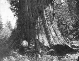
Cedar tree, 50 ft. in circumference, on Park Road, Vancouver, B.C.
Part of Major Matthews collection
J.S. Matthews' notes with print or negative in Archives.

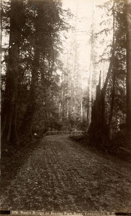
Rustic bridge on Stanley Park Road, Vancouver, B.C.
Part of Major Matthews collection
J.S. Matthews' notes with print or negative in Archives.

Spruce tree, 44 ft. in circumference, Stanley Park, Vancouver, B.C.
Part of Major Matthews collection
![From Park Road, Showing Mission [in North] Vancouver](/uploads/r/null/e/a/ea84794d38d5194b79fb6f1d973a13b703523d6a784b302853d965a53b82552c/300ce682-c55a-4925-9c09-1f6f96286f95-A36844_142.jpg)
From Park Road, Showing Mission [in North] Vancouver
Part of Major Matthews collection

Part of Major Matthews collection
J.S. Matthews' notes with print or negative in Archives.
![[Ferns and trees near the end of Pipe Line Road]](/uploads/r/null/3/4/34262494ab0b9947d0154f55e57037aa7160938378320dd225679d154ce289a4/2c0da2f7-bc23-4be1-932a-ac3b59812034-A36814_142.jpg)
[Ferns and trees near the end of Pipe Line Road]
Part of Major Matthews collection

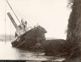
Wreck of the Beaver, Prospect Point
Photograph shows the S.S. Beaver laying on its side on the shore.

Prospect Point, S.S. Beaver wrecked at entrance to 1st Narrows, Vancouver, B.C.
Part of William Orson Banfield fonds
City of Vancouver : Canadian Pacific town site
Part of City of Vancouver Archives technical and cartographic drawing collection
Primary map shows lot numbers and boundaries, streets, fire limits and "soundings in feet" (in English Bay, Burrard Inlet, Coal Harbour and False Creek) in downtown Vancouver, Stanley Park and parts of Kitsilano and Fairview. The ancillary maps show an "Index plan of Vancouver, B.C.", an "Index plan of [Vancouver] city limits" and "Canadian Pacific Mail Steamship Lines" (a map of Canadian Pacifc steamship routes around the world). On recto, the item also includes a description of Stanley Park and an illustration of Vancouver's inner harbour. On verso, the item includes descriptions of major Vancouver residences, imports, exports, businesses and other landmarks.

![[View from Observation (Prospect) Point]](/uploads/r/null/3/4/348b09fd0222e7b4a3b7d44053f86bc24fd0a55b158034dac96be4a9b6a44cc1/53e73265-7166-49aa-a573-0ad3ed19d106-A36815_142.jpg)
[View from Observation (Prospect) Point]
Part of Major Matthews collection

Part of Stanley Park Road on Brockton Point Vancouver, B.C.
Part of Major Matthews collection
![[Two men in rowboat near Prospect Point, and wrecked ship "Beaver" in the distance]](/uploads/r/null/7/f/7fe869f0c4b06f7db9cef33b5dab4c426a94a32ce2d51bfba9b7be841e4178d6/45d6df69-9db5-4a54-be65-1d8c07399141-A04083_142.jpg)
[Two men in rowboat near Prospect Point, and wrecked ship "Beaver" in the distance]
Part of Major Matthews collection
J.S. Matthews' notes with print or negative in Archives.
![[Two men standing on the wrecked ship S.S. "Beaver" at Prospect Point in Stanley Park]](/uploads/r/null/f/e/fe99b606732b9a5d48084361f28eff26d40488bebb5efa402fa341053d5454dc/f41141f2-9dc7-42f0-9d62-d17068ab3d71-A04854_142.jpg)
[Two men standing on the wrecked ship S.S. "Beaver" at Prospect Point in Stanley Park]
Part of Major Matthews collection
J.S. Matthews' notes with print or negative in Archives.
Rustic bridge on Stanley Park Road, Vancouver, B.C.

Photograph shows a man in a canoe

The Narrows from Stanley Park Road, Vancouver, B.C.
![[Man leaning against] Cedar tree, 50 ft. in circumference, Stanley Park, Vancouver, B.C.](/uploads/r/null/d/7/d7446e915bb432485601d8931c3e45e22c02c6b073c1e11a820c7b8d5dd82b38/5be7c2ce-2876-488d-b48c-88ed115ec492-A71342_142.jpg)
[Man leaning against] Cedar tree, 50 ft. in circumference, Stanley Park, Vancouver, B.C.
Photograph shows four men posing on the wrecked ship at Prospect Point.
A peep at observation point from Stanley Park
Part of City of Vancouver Archives documentary art collection
Ferris, William
![[View of the First Narrows from Prospect Point]](/uploads/r/null/2/4/2496bc3c3b2491d87867e8b7c1117429fd97eea7916ae21c6d58077e7537b5d6/754565dd-6029-4205-b5db-2ed739f5761c-A36785_142.jpg)
[View of the First Narrows from Prospect Point]
Part of Major Matthews collection
![[Three women assembled around driftwood on Stanley Park beach near Brockton Point]](/uploads/r/null/a/1/a19061ad4c25f37a7d7304934454482f39e65cfde6b023236930b60d4a7c56fb/3bf848ec-ef96-4f0e-a175-82f6101d68db-A04038_142.jpg)
[Three women assembled around driftwood on Stanley Park beach near Brockton Point]
Part of Major Matthews collection
J.S. Matthews' notes with print or negative in Archives.

Spruce Tree 38 feet in circumference in Bower, Vancouver Public Park
Part of Major Matthews collection
Photograph shows a man holding a rifle
![[Man standing next to] Cedar tree, 50 ft. in circumference, on Park Road, Vancouver, B.C.](/uploads/r/null/d/4/d450d1c7b957469c5d1d12f6b6521bafc53350a236ca1942f160f788d25389e8/c0e37b28-2faf-4799-ac5e-119a9b29e3cf-A04006_142.jpg)
[Man standing next to] Cedar tree, 50 ft. in circumference, on Park Road, Vancouver, B.C.
Part of Major Matthews collection
J.S. Matthews' notes with print or negative in Archives.
![[Spruce Tree 44 Feet in Circumference]](/uploads/r/null/a/d/ad67863493bcc9f17ae01d6d5220e75e288176aaa38d8670f2beeba65f26a8e4/9302d4c1-66a0-493f-9058-fac9ef64fae2-A36737_142.jpg)
[Spruce Tree 44 Feet in Circumference]
Part of Major Matthews collection
![[Second Beach]](/uploads/r/null/6/c/6ccd909496372c3b11fb4cc1d46cf1ab6aafbc015a6ad4031f8e5046b6f2c6bc/c7749bec-5d5a-4435-93cf-da682e635be6-A36786_142.jpg)
Part of Major Matthews collection
![[Two men playing cards in the middle of a logging road in Stanley Park]](/uploads/r/null/8/5/853bc7a57f8925e2b9214b7d7450e776e4e7d8ed0f2beeb9abc0d0c8cd6dc2cb/399b3920-a0a9-4138-938b-f0a4df1bc39f-A04043_142.jpg)
[Two men playing cards in the middle of a logging road in Stanley Park]
Part of Major Matthews collection
J.S. Matthews' notes with print or negative in Archives.
![[Presbyterian Church at Brockton Point]](/uploads/r/null/7/0/70c9e42e16631314e0c28ee8d0e88c8bb7e3d375eece8e1a36690ce50e116e51/31e1d897-5e26-4294-9275-c8b604562dd0-A25618_142.jpg)
[Presbyterian Church at Brockton Point]
Part of Major Matthews collection
Group portrait showing Jane Carmichael Fraser, Dr. W.J. McGuigan and others
![[Woman seated on driftwood on Stanley Park beach near Brockton Point]](/uploads/r/null/5/8/58f0bfc65edb630757b890ad34605965fe742dbd1c82c9094dec323676040ecd/931c8239-99eb-44ac-9a6c-dd80e652a3d7-A04037_142.jpg)
[Woman seated on driftwood on Stanley Park beach near Brockton Point]
Part of Major Matthews collection
J.S. Matthews' notes with print or negative in Archives.

Autumn in Stanley Park, Vancouver, B.C.
Part of Major Matthews collection
Photograph shows three men in a carriage on a dirt road surrounded by trees and bush. J.S. Matthews' notes with print or negative in Archives.

Cedar tree 80 ft. in circumference, Stanley Park, Vancouver, B.C.
Part of Major Matthews collection
Photograph shows a horse-drawn carriage backed into the Hollow Tree at Stanley Park
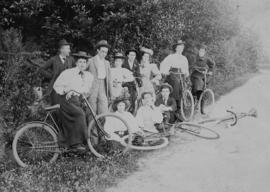
Photograph shows a group of men and women with bicyles at the side of a dirt road.
![[Men and women eating strawberries at a picnic in Stanley Park]](/uploads/r/null/f/8/f80769ec4b7908a0d95406fc70630538e463b2849f50e4470c3391a8ca72b291/8e26d33e-9bd3-43d6-aa26-126fdc8344d9-A04411_142.jpg)
[Men and women eating strawberries at a picnic in Stanley Park]
Part of Major Matthews collection