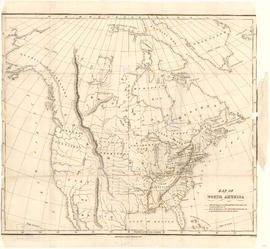
Map of North America

Map of Manitoba, Kewaydin, British Columbia and North West Territory shewing the country traversed by the Canadian Pacific Railway

Muir Glacier at Glacier Bay - 350 feet above water

"Huktown" an Indian village near Juneau

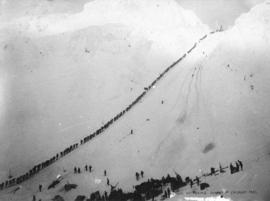
Scales and Summit of Chilkoot Pass
![Alaska Steamship Co's Flyer ["Dolphin"]](/uploads/r/null/c/f/cf6edfecf584c3af176593b4f9cf5c9b8796dd2c988756d5d6633f66e4884405/6f5ef731-dafd-44c3-a2c1-680e84d4892e-A23961_142.jpg)
Alaska Steamship Co's Flyer ["Dolphin"]
Packer Ascending Summit of Chilkoot Pass

The Bridge Across Porcupine Creek
![Winter Trail on Skaguay [Skagway] River](/uploads/r/null/6/7/674b4bdbec738165c57c0f2d54e15dbfbd1420b9bebe68e88fda401d840b5a64/0370f36b-9041-4f42-8b23-bef2cf53cf27-A37393_142.jpg)
Winter Trail on Skaguay [Skagway] River
![Winter Trail Through Box Canyon on Skaguay [Skagway] River](/uploads/r/null/0/7/0785fff790a14b7292efb2e43528871758ca896d378d36efa7593e2cec6e5dd7/67f52ed1-58bf-4a07-ba69-a2b9eefb6439-A37395_142.jpg)
Winter Trail Through Box Canyon on Skaguay [Skagway] River

Uncle Ned's Hotel at the Third Bridge
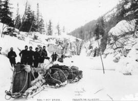
Near First Bridge En Route For Klondike

Portage Between Lakes Linderman and Bennett
![At The Cutoff Skaguay [Skagway] Trail](/uploads/r/null/b/7/b799893aa32e56051e2204b1d1b090f413674f416b42ae10b65eefb72c815edc/c1c4b0bd-3c4f-494c-97c2-603b5b3b99d0-A37402_142.jpg)
At The Cutoff Skaguay [Skagway] Trail
![Skaguay [Skagway] Trail Alaska](/uploads/r/null/d/9/d9b982a440c6ef469ce847f748a73fd53af9e692f76d53eda0ed19410e2486d7/7f7e1f00-b536-4134-94c8-b9788ea30c08-A37394_142.jpg)
Skaguay [Skagway] Trail Alaska
![[First Nation's wooden burial huts]](/uploads/r/null/2/0/201581ee5cdfa5c85fda525fd6d037991c7464ee5329ac6a7943703b41d99884/f6501fa7-488e-4fe7-948a-84ce72a7ef07-A24200_142.jpg)
[First Nation's wooden burial huts]
![[First Nations family in front of house]](/uploads/r/null/7/9/79849ae21ae8d74c0cf62c5a89f496ffe7170a5b1edfaf3d16457c9d00b7e908/874fcd0b-7a23-4f18-8d44-2c7166ead400-A24208_142.jpg)
[First Nations family in front of house]
![[First Nations women]](/uploads/r/null/d/c/dcf1ad17e3153eaeb6fd4d2ed2f2aa92a65c215c445c40a15e498a03e2bc33ba/78bf0678-cf62-4a54-825a-536494bbac4c-A24211_142.jpg)
[First Nations women]
![[View of mountains and icebergs from the S.S. "Queen"]](/uploads/r/null/b/b/bb6ba4d4f9098d83b1eadba65d5c50f5fb905f03e296613af39ace20cf8d2e58/8640acf1-b289-417c-963f-a804e7d8097f-A24183_142.jpg)
[View of mountains and icebergs from the S.S. "Queen"]
![[View of peninsula from the S.S. "Queen"]](/uploads/r/null/8/6/86d38c35c5395ca537e9394a613257b5121d74137f350a7956b31899d2831d7f/11c603e7-2c44-4a82-9113-2bbc7a39ad78-A24192_142.jpg)
[View of peninsula from the S.S. "Queen"]
![[Ice being hoisted to the S.S. "Queen"]](/uploads/r/null/8/2/8217816b227afb0445e7e92c3f2d5b8a56c48fced8953cb39f1945e308d0001c/18b7ee8a-9905-49d9-93b2-549f449e3b9d-A24182_142.jpg)
[Ice being hoisted to the S.S. "Queen"]
![[House and totem poles]](/uploads/r/null/8/c/8c79e5e3fff8f482f8c8d622bd9d880ef52544be88ba11b923906f586000deee/b1e370fc-edad-4665-8831-1029b9c73499-A24188_142.jpg)
[House and totem poles]
![[Rowboats from the S.S. "Queen" near a glacier]](/uploads/r/null/a/5/a580bfbd1543bd54b740de3527a6bb85cbef9599e2bd5fb2cba2fffffbf1f9c4/f37ac959-5a12-4f0e-8131-61d7056b0c68-A24202_142.jpg)
[Rowboats from the S.S. "Queen" near a glacier]
![[S.S. "Queen"]](/uploads/r/null/a/b/ab613af6c40ec9fa42467de8aaddea02ab7c84748fd389140aa69d76b585f565/4b8ef7f8-4391-4066-a526-59ed4602f177-A24187_142.jpg)
[S.S. "Queen"]
![[Glacier]](/uploads/r/null/e/0/e0a027469fb46fa7740c94c9e8d663716fcb4da07dfe03f234ac7434978bdcd4/fceb32df-2957-4d6b-9c32-59377bad3bb2-A24204_142.jpg)
[Glacier]
![[Bear cub chained to a post]](/uploads/r/null/d/3/d3493c8d3a11cb13d960219952add8a6fa02c54237b5e51e291f34b9751bb27f/17e4a192-2596-4496-b96a-45cccf2ff5d9-A24213_142.jpg)
[Bear cub chained to a post]
![[View of icebergs and moutain from the S.S. "Queen"]](/uploads/r/null/d/6/d6a057483a8a8d188c19a9deb8b882726ff412c8d62eb9a6f59a1b271811aa12/2a580bb3-2069-46c3-8c45-d94b16a4613f-A24181_142.jpg)
[View of icebergs and moutain from the S.S. "Queen"]
![[View of mountains and icebergs from the S.S. "Queen"]](/uploads/r/null/1/9/1980527efd3ffc83998df85474d18f29d9fdb3c995a5f981c2559855da8c360c/5df7d2d5-b6a7-49a1-a1f1-2e1d0a4834e8-A24184_142.jpg)
[View of mountains and icebergs from the S.S. "Queen"]
![[Glacier]](/uploads/r/null/b/6/b6879e5f5404008be87253c50c47eeb205eec85a601a83b2fd785211517c1a3e/881d0b16-c2f8-43cf-aed0-b23a86335a2d-A24203_142.jpg)
[Glacier]
![[House and totem poles]](/uploads/r/null/1/3/13e8e431fc6cec967d21122076e422446c993b89e79237f3a58a9a14e78d7bfe/f2a9b7e4-7c35-4577-88fe-e5a90266f3c5-A24186_142.jpg)
[House and totem poles]
![[Church]](/uploads/r/null/c/8/c8808cba044fc48fa786aa41e110d31900d001f70f1633f55301ff76a7fcf4fe/08cce832-6237-4ad1-ad33-f4b8bdce4bd3-A24199_142.jpg)
[Church]
![[First Nations children on porch]](/uploads/r/null/8/f/8f28fb17e12b9f4b863b0eb07cb388cf2066dbc2051c4e73f55aa94c69ee2a4d/4727c973-1005-4747-b3e0-407cc6676be6-A24209_142.jpg)
[First Nations children on porch]
![[First Nations women and boy on beach]](/uploads/r/null/6/0/60e66bd8159bd59af5c32aa57a0a2ebb4441132b0af6de4e3b4f804ceeadb27d/0ce288e2-b00c-44b4-a048-e3cb0048fa58-A24193_142.jpg)
[First Nations women and boy on beach]
![[First Nations women and children outside log cabin]](/uploads/r/null/3/5/35f81d9de558bb514e31b8056b395a7dbfadd78eaa7b20368b6f214dc1f66508/28df7023-d88b-4566-a961-400429a6e1c3-A24194_142.jpg)
[First Nations women and children outside log cabin]
![[Woman beside First Nations wooden carving]](/uploads/r/null/1/e/1e517f78775157ad9fe4a10b600edf2b0a7c5b19adc720272e656784f2f0a2cf/7453c478-45a1-447e-95e7-2bf63c2abeec-A24212_142.jpg)
[Woman beside First Nations wooden carving]
![[View of mountains from the S.S. "Queen"]](/uploads/r/null/9/b/9b696468333f608d3f372fb8142fb21757f901c7a7cca1b2474dc7f46ed61015/e2000554-76ba-44f4-9b97-960889326896-A24179_142.jpg)
[View of mountains from the S.S. "Queen"]
![[The S.S. "Cutch" foundering 25 miles south of Juneau]](/uploads/r/null/9/6/5/96534c96c0dbb31cdeed627813e8090244b5362158a9e00bf144878ca3c1a260/99c3ae08-a3c9-4d38-960f-841610535fa7-CVA260-1178_142.jpg)
[The S.S. "Cutch" foundering 25 miles south of Juneau]
![[The S.S. "Cutch" foundering 25 miles south of Juneau]](/uploads/r/null/9/9/1/991a927e011149702d14f4b9bc66b30d720c4cac9b5da644d1288e27f3d016e3/02ae6c3e-28a9-4bbf-93e9-114b3db2b09a-CVA260-1180_142.jpg)
[The S.S. "Cutch" foundering 25 miles south of Juneau]
![[Glacier]](/uploads/r/null/9/9/997af61b13cdc66498fc40e5cdce986547a06d53680074d76a9d456b4ac4b34c/b9a8ce00-ee7e-4087-b4fa-84ca7803dc45-A24206_142.jpg)
[Glacier]
![[Glacier]](/uploads/r/null/d/b/db50dbf49046c32ff036e6eb5c180bd1a5bd93e96fe6eb3e0aad9f30b1c58b19/fec56ade-ef89-4d85-8150-fff01a4728f4-A24207_142.jpg)
[Glacier]
![[First Nations children playing in water]](/uploads/r/null/6/9/69b7bf616b502bc7284b2eb8f568fb23947d1c93729efd5bbb2e649d78fb4f0e/bc67a08c-b51f-4e89-95a3-69972106aa57-A24210_142.jpg)
[First Nations children playing in water]
![[Log cabin and house]](/uploads/r/null/d/5/d50aa09f5bf43bd636af5cd424b32c62a9fb87c5fa5fab344b1d5438ac81cf3e/b44359f0-3fe1-4838-ba5e-67c567a597ff-A24191_142.jpg)
[Log cabin and house]
![[S.S. "Queen"]](/uploads/r/null/6/8/6877e70670b9178fb137047dec4e950368ca6fb0936c16e1fb9a845d76342f68/90650550-caa0-4207-a3c8-31733b1ffa6a-A24189_142.jpg)
[S.S. "Queen"]
![[The S.S. "Cutch" foundering 25 miles south of Juneau]](/uploads/r/null/4/1/9/419ca95a7cf5c2d3f4222233126a7674adba00b372ad62745327bf868248354f/2068ada2-90ca-43fc-b745-ce136862ac99-CVA260-1179_142.jpg)
[The S.S. "Cutch" foundering 25 miles south of Juneau]
![[Glacier and mountains]](/uploads/r/null/b/3/b36dcc44111cf40940e81e2b83511df021a0ca7a9d9695078ff80aad3c8a3ba0/a3afc39e-1dbb-4e64-956c-f0943cec6d6a-A24205_142.jpg)
[Glacier and mountains]
![[First Nations boys]](/uploads/r/null/d/6/d63939595cbda0fee033f27889110eb6252b86826c4949340fd8c68bab1f55bf/5b34031c-a7e0-422b-aa99-8a5eead24f36-A24195_142.jpg)
[First Nations boys]
![[First Nations wooden burial huts]](/uploads/r/null/6/9/69ecc2a9024edea30f7c45338acdae6167ef158afe648ad815abd857d88a480f/b63328ad-a660-4e01-97b0-a7ca31afeb2d-A24201_142.jpg)
[First Nations wooden burial huts]
![[Houses on stilts and totem poles]](/uploads/r/null/3/6/3698828703c992e89a0cd1c818f9a2446a78ad154231eba08f38557bfd0ea0b8/a52b0767-1423-4335-8d32-c1d20a699500-A24198_142.jpg)
[Houses on stilts and totem poles]
![[Totem pole]](/uploads/r/null/5/1/51d946bc0ef3b45b9ac665ef9ab63985b1bcfaffd260e0d7511fcef5a7c689ea/d8886e74-0216-41a2-a0ce-bb5d5d7b0631-A24190_142.jpg)
[Totem pole]
![[View of First Nation's village]](/uploads/r/null/c/d/cdc9dd7ca63efbeb74dfb4f26f95050a4da4a9b617b6e9d0ae12c7fa298f5262/aa8affdd-0783-4bb2-9ef9-96bd584da038-A24197_142.jpg)
[View of First Nation's village]