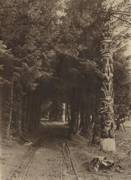
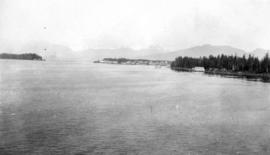
Roadway and totem pole in Sitka
- AM1376-: CVA 568-1
- Item
- [ca. 1906]
Item is a photograph showing a pole situated in the Sitka National Historical Park, Alaska.
94 results with digital objects Show results with digital objects
Roadway and totem pole in Sitka
Item is a photograph showing a pole situated in the Sitka National Historical Park, Alaska.
![[The S.S. "Cutch" foundering 25 miles south of Juneau]](/uploads/r/null/9/9/1/991a927e011149702d14f4b9bc66b30d720c4cac9b5da644d1288e27f3d016e3/02ae6c3e-28a9-4bbf-93e9-114b3db2b09a-CVA260-1180_142.jpg)
[The S.S. "Cutch" foundering 25 miles south of Juneau]
Part of James Crookall fonds
![[The S.S. "Cutch" foundering 25 miles south of Juneau]](/uploads/r/null/9/6/5/96534c96c0dbb31cdeed627813e8090244b5362158a9e00bf144878ca3c1a260/99c3ae08-a3c9-4d38-960f-841610535fa7-CVA260-1178_142.jpg)
[The S.S. "Cutch" foundering 25 miles south of Juneau]
Part of James Crookall fonds
![[The S.S. "Cutch" foundering 25 miles south of Juneau]](/uploads/r/null/4/1/9/419ca95a7cf5c2d3f4222233126a7674adba00b372ad62745327bf868248354f/2068ada2-90ca-43fc-b745-ce136862ac99-CVA260-1179_142.jpg)
[The S.S. "Cutch" foundering 25 miles south of Juneau]
Part of James Crookall fonds

Part of Major Matthews collection

![Princess May wrecked on Sentinel Is. Alaska[,] Aug. 5, 1910.](/uploads/r/null/6/4/e/64e7b8fd8d4c9f4360d9f26403ed9764774eb2c29505190c45f3ecf08f6e8431/36bedfb8-ae07-4124-b433-c6da34125c3d-AM1052P-131_142.jpg)
Princess May wrecked on Sentinel Is. Alaska[,] Aug. 5, 1910.
Item is a postcard printed with an image of the Princess May wrecked on Sentinel Island.

![[Performance of the] "Shooting of Dan McGrew" on the "S.S. Prince George"](/uploads/r/null/4/d/4dd08f9b04c8aa371afc52a4319fa9ad5d98c8d4bd5429732f6bb7be7b0c94b4/e748cb94-03c4-4c70-8c0e-ab7501e61951-A06768_142.jpg)
[Performance of the] "Shooting of Dan McGrew" on the "S.S. Prince George"
![[Passengers in the dining room on [the] "S.S. Prince George"](/uploads/r/null/f/9/f9d795ea4de014330a47206ad23c76ed4e19da891c7368c8ba41cde480f841fe/d5ed19ce-3352-44de-8ac9-6c65fce92d34-A06767_142.jpg)
[Passengers in the dining room on [the] "S.S. Prince George"
![[Passengers in the dining room] on the "S.S. Prince George"](/uploads/r/null/0/f/0fc158e3cb161b4c06aba49112ff1de5018ac6a2a9c04111e2afa5e8d47c54f7/d2c3dedb-239d-483f-92d9-bd7ba9941501-A06766_142.jpg)
[Passengers in the dining room] on the "S.S. Prince George"
![[Performance of the] "Shooting of Dan McGrew" on "S.S. Prince George"](/uploads/r/null/6/e/6e6fe12933e7d3646cf189cd909abd31f6af8e26a16c043161a8cd21ed311fe9/908fcd76-0c9f-48eb-94dc-188e322db4f9-A06765_142.jpg)
[Performance of the] "Shooting of Dan McGrew" on "S.S. Prince George"
![[Performance of the] "Shooting of Dan McGrew" on "S.S. Prince George"](/uploads/r/null/d/8/d89b4add2ab29816f99a887550376d1507f626444b182b1b1b56b1a77cf96559/055da6b1-c530-4bf2-b173-f8661e151257-A06764_142.jpg)
[Performance of the] "Shooting of Dan McGrew" on "S.S. Prince George"

Kodak Safety 138

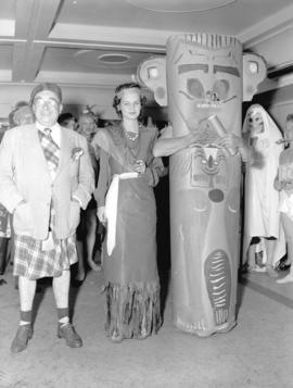
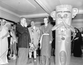
Photograph shows three participants in the masquerade.
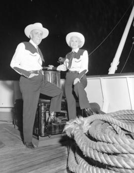
Photograph shows participants in the masquerade dressed in matching cowboy/cowgirl costumes.

Photograph shows a participant in the masquerade dressed as "Departed Spirits".

S.S. "Princess Kathleen", C.P.R.

![Passengers [and crew playing] games on "Prince George"](/uploads/r/null/d/9/d984cc275cec2c6f13929dc68073c6d5c2dc5bc901174f753a55c1f36d1fe4bf/b76e446c-cff9-4d73-8ef0-7822978ef024-A06749_142.jpg)
Passengers [and crew playing] games on "Prince George"

White Pass and Yukon Railway - passenger coaches

White Pass and Yukon Railway - passenger coaches.

Part of City of Vancouver Archives technical and cartographic drawing collection
Item is a map showing the extent of the Canadian Pacific Railway Company (C.P.R.) in Canada in 1883. Map shows boundaries, roads, trails, telegraph lines, towns, rivers, lakes and mountainous terrain in British Columbia, the North West Territory (Alberta, Athabasca, Saskatchewan, Assiniboia), Manitoba and Kewaydin, as well as some of Ontario and Western Quebec. Map is folded inside a book titled "North West Territory, Canada."
![[Brigadier Sherwood Lett]](/uploads/r/null/a/e/ae83b9cd149752ce478f9ef67c123dac215a48c7a47dfa8d2016919c5ecf5b98/7fb64f6e-2b5a-4535-a914-054984ae1044-A59864_142.jpg)
Part of Major Matthews collection
Part of William Orson Banfield fonds
Item is a photograph showing Petersburg, Alaska from the Prince Rupert.
Part of City of Vancouver Archives technical and cartographic drawing collection
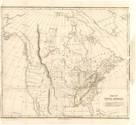
Item is a map showing "Mr. Stuart's route through the United States, and Canada in 1828, 29 & 30" and "the boundary of the United States, both on the side of the British Possessions, & those in Mexico." The northern border of United States territory west of the Rocky Mountains is incorrectly noted at 54/40, to reflect American claims of the time.
![[Two views of glaciers in Alaska taken from a USS boat]](/uploads/r/null/1/7/17dd5e31001cfbc6f7a42acc8770c083189540be0a3686bb3fa46777e17a97d0/9097dfee-7d55-4076-87d2-3d8e03ba61a7-A11576_142.jpg)
[Two views of glaciers in Alaska taken from a USS boat]
![[Two views of a town in Alaska]](/uploads/r/null/6/0/600a78d331728519ca351dd480c61191452ffa13633305a57b4830a9d33a66d3/c4adb677-3f69-423e-a7cc-6dd6ecbb7025-A11575_142.jpg)
[Two views of a town in Alaska]
Photographs show buildings and an industrial area.
![[Film crew loading supplies onto USS boat in Alaska; Alaskan scenery taken from a USS boat]](/uploads/r/null/d/7/d7bb22e660e670046b6b56435dd8888d6bf74e8bbe305c2d9674b07deb90c94e/ac27b624-270a-4ccc-b535-cc68466ef735-A11574_142.jpg)
[Film crew loading supplies onto USS boat in Alaska; Alaskan scenery taken from a USS boat]
![[Film crew shooting glaciers in Alaska from a USS boat]](/uploads/r/null/8/d/8dffcc11da238d5cb8350ea08b24b75645ab7246210bace54a64897194acb9aa/6cb83340-e3ca-4f28-9d8a-9fb7f5b9b691-A11573_142.jpg)
[Film crew shooting glaciers in Alaska from a USS boat]
![[Alaskan glacier from USS boat; Film crew shooting glaciers in Alaska from USS boat]](/uploads/r/null/0/a/0ae1e404210777c1ce17d0146da5e486d7a707cf80c7547e42b0802ab8bdc2d9/492da0e4-6142-4ae6-b0bd-761bd0fe0f94-A11572_142.jpg)
[Alaskan glacier from USS boat; Film crew shooting glaciers in Alaska from USS boat]
![[Two views of glaciers in Alaska taken from a USS boat]](/uploads/r/null/d/1/d13299fcee2cbd4ef5e5d68c3b28285d86e2f34ba1def7c24ee85f6aa3f47559/c13d2d3f-c793-4870-88ec-5a6bead96f8e-A11571_142.jpg)
[Two views of glaciers in Alaska taken from a USS boat]

Tongass National Forest, Alaska : Copper River Meridian
Item is a map of the Tongass National Forest showing roads, trails, railways, triangulation stations, dwellings, schoolhouses, mines, landing strips, airfields, and international, national forest, and national monument boundaries. Two smaller maps show the location of the Tongass National Forest in relation to the rest of Alaska and the far northwest portion of the forest not shown on the primary map.

Muir Glacier at Glacier Bay - 350 feet above water

"Huktown" an Indian village near Juneau
![Streptopus roseus ssp. curvipes [at] Mount Robinson Alaska](/uploads/r/null/2/9/2964fc298c94da84602b8af58a110a0cbf09f79d764454b347f573cad85f256f/5f738ac1-8c7e-4d6b-ae98-6bea78055ca3-A58150_142.jpg)
Streptopus roseus ssp. curvipes [at] Mount Robinson Alaska

Dodecatheon pulchellum : Juneau

Wildlife : Bald Eagle Juneau Alaska

Wildlife : Bald Eagle Juneau Alaska
![At The Cutoff Skaguay [Skagway] Trail](/uploads/r/null/b/7/b799893aa32e56051e2204b1d1b090f413674f416b42ae10b65eefb72c815edc/c1c4b0bd-3c4f-494c-97c2-603b5b3b99d0-A37402_142.jpg)
At The Cutoff Skaguay [Skagway] Trail
Part of Major Matthews collection
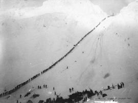
Packer Ascending Summit of Chilkoot Pass
Part of Major Matthews collection

Scales and Summit of Chilkoot Pass
Part of Major Matthews collection
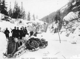
Near First Bridge En Route For Klondike
Part of Major Matthews collection
Photograph shows W.H. Lang and party

The Bridge Across Porcupine Creek
Part of Major Matthews collection
Photograph shows W.H. Lang and party

Uncle Ned's Hotel at the Third Bridge
Part of Major Matthews collection
Photograph shows the W.H Lang party in front of two log structures

Portage Between Lakes Linderman and Bennett
Part of Major Matthews collection
Photograph shows men and sled dogs stopping for refreshements
![Winter Trail Through Box Canyon on Skaguay [Skagway] River](/uploads/r/null/0/7/0785fff790a14b7292efb2e43528871758ca896d378d36efa7593e2cec6e5dd7/67f52ed1-58bf-4a07-ba69-a2b9eefb6439-A37395_142.jpg)
Winter Trail Through Box Canyon on Skaguay [Skagway] River
Part of Major Matthews collection
Photograph shows W.H. Lang and party
![Skaguay [Skagway] Trail Alaska](/uploads/r/null/d/9/d9b982a440c6ef469ce847f748a73fd53af9e692f76d53eda0ed19410e2486d7/7f7e1f00-b536-4134-94c8-b9788ea30c08-A37394_142.jpg)
Skaguay [Skagway] Trail Alaska
Part of Major Matthews collection
Photograph shows two dead horses