![[Mr. and Mrs. Dagliesh and guests outside Dagliesh residence at Jericho]](/uploads/r/null/2/b/2bb7058769b06ca8d35774d11aee5f67fe776af9b7dbe5ae4e5e1c64cc91ce43/9fc5b3cc-4995-4519-9cff-06ac360c4302-A04064_142.jpg)
[Mr. and Mrs. Dagliesh and guests outside Dagliesh residence at Jericho]
![[Mr. and Mrs. Dagliesh and guests outside Dagliesh residence at Jericho]](/uploads/r/null/a/8/a821eae8ef05d3d4aba34c39fd92eeca38f811eeec3883da876ba133c95d2f00/a9819209-a857-466c-bd20-17e981e37c57-A03927_142.jpg)
[Mr. and Mrs. Dagliesh and guests outside Dagliesh residence at Jericho]
![[View of Fitzgerald McCleery's farm buildings - D.L. 315]](/uploads/r/null/6/e/6e5f9c3c168c680a3efe1c39bd6816255228a501c4755035516a4a90f3520e16/a839d990-cc7b-4fe5-a9b7-d3bc8b6a4d26-A24683_142.jpg)
[View of Fitzgerald McCleery's farm buildings - D.L. 315]
![[View of Fitzgerald McCleery's orchard and farm lands - D.L. 315]](/uploads/r/null/7/2/721836cd34c66c561ba28967c3503a468d637ab54195f3f782574da26255ef73/be7b8e06-810d-452c-980a-196fe3504ee4-A24684_142.jpg)
[View of Fitzgerald McCleery's orchard and farm lands - D.L. 315]
![[Looking west on Magee Road (49th Avenue) from East Boulevard]](/uploads/r/null/e/d/ed0d80fd240487107763470afce52370d29182834c293199ad537b788fc7a9e0/5292a694-3e82-4204-9544-fa40a359e573-A37363_142.jpg)
[Looking west on Magee Road (49th Avenue) from East Boulevard]
![[Jericho Country Club]](/uploads/r/null/b/8/6/b86d716b23dc5bf5a6b72c3fe01813de3627aa3d9c2c8c1647ae16fd6e7c13f2/5c910c23-4a9c-48f6-adfd-1bb472379668-VLP170_142.jpg)
[Jericho Country Club]

Plan of sub-division of lot 2027, group 1, New Westminster District, B.C., to be sold by public auction at Vancouver, B.C.
Photograph album, 1907-1918
Photograph album, 1907-1918

First Jericho Country Club clubhouse

Man and woman on balcony of Jericho Clubhouse, looking across beach to north shore
![[Exterior of Boy's Industrial School (Jericho Hill School) at 4100 West 4th Avenue]](/uploads/r/null/e/6/e6bfa91380e8eb2ff7067665d8a433b5eee5e96b4dbd10330b70990df190a81d/5a5c2f3e-6e37-478a-886a-9f8a1fbafd12-A36493_142.jpg)
[Exterior of Boy's Industrial School (Jericho Hill School) at 4100 West 4th Avenue]
[Human burial with artefacts unearthed near Eburne Indian midden]
[Human burial with artefacts unearthed near Eburne Indian midden]

A. Kam on original first tee at Jericho Golf Course

Jericho Club's horse pulling a mower
Plan of Point Grey municipality
Plan of Point Grey municipality
![[A man examines bones that were exposed when the Marpole Midden was plowed]](/uploads/r/null/e/1/e17c0371c2cbf3cb36d5fa2c82cb8bc023be6e9ebb9546909246f98ff204b149/00de55ac-a12b-4491-8125-e189defb24e0-A37354_142.jpg)
[A man examines bones that were exposed when the Marpole Midden was plowed]
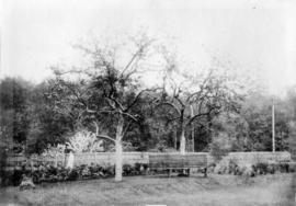
Garden surrounding original Jericho Clubhouse
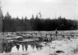
Woman on old footbridge crossing slough at Jericho Golf Club

Man and woman on first green at Jericho Golf Course

View looking north west from the Jericho Clubhouse

Old cart bridge across slough on Jericho Golf Club property

Men approaching fourth green with house of J. MacKenzie Bowell under construction in the distance

A. Kam, club professional, on fourth tee

Left portion of Panorama, view from Point Grey

Middle portion of Panorama, view from Point Grey
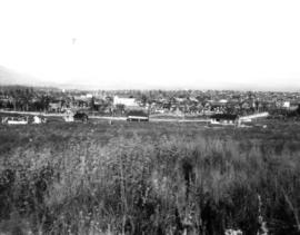
Right portion of Panorama, view from Point Grey
![[Southern view of Samuel and Fitzgerald McCleery's farms - District Lots 315 and 316]](/uploads/r/null/2/9/e/29e5e2ee1ab72e418f96f7141a35b69a66da2b5808f04d8af443c2fdae390ef2/d22eb2ef-a370-4cc4-99f3-9ddec8fddaf8-LP355_142.jpg)
[Southern view of Samuel and Fitzgerald McCleery's farms - District Lots 315 and 316]
![[View of Hudson Street, looking south toward the Eburne Railway Station]](/uploads/r/null/e/0/e02af163a2bc02f2c8f814358e4f275fff14ea65f75638334d3f2247b2325e6d/19e19d75-4759-4c0e-97c1-fdcbd9c55151-A08302_142.jpg)
[View of Hudson Street, looking south toward the Eburne Railway Station]
Plan of Point Grey Municipality
Plan of Point Grey Municipality
![[Dunbar Street?]](/uploads/r/null/3/e/3ed8eb314f3553b8446f5bde69b1666f31ffd336d5be438201b9e49a29bb60d1/42627732-ea15-4eb1-a9a3-d87a1f992e23-A16596_142.jpg)
[Dunbar Street?]
![[The Briggs family on the steps of their house at 25th Avenue and Carnarvon Street]](/uploads/r/null/6/f/6f3949af34bed93b00f55d62ba258fbcc7cff66a115bb17b752999152151b0ab/e6f7072a-773e-4983-ae78-f64d90d7d359-A61071_142.jpg)
[The Briggs family on the steps of their house at 25th Avenue and Carnarvon Street]
![[View looking North of Fitzgerald McCleery's farm - District Lot 315]](/uploads/r/null/e/f/2/ef2ed8b0811118507913e4d976d8ae641c3fbd921cbe3939fc913f6eee0b42e1/62ba7470-1c4b-4284-bdd8-b755b6364802-LP355_142.jpg)
[View looking North of Fitzgerald McCleery's farm - District Lot 315]
Kitsilano and the Municipality of Point Grey
Kitsilano and the Municipality of Point Grey
![[Point Grey Police Motorcycle Squad in front of the Municipal Hall]](/uploads/r/null/c/3/c3a0a4387b241c02618b34ecc24e7952d42482ff37c951fc50abac0ce9b6e354/e3bd1c30-7b3b-454c-a829-1ffc9d9721e0-A34179_142.jpg)
[Point Grey Police Motorcycle Squad in front of the Municipal Hall]

Lot numbers, boundaries, railway lines and street names in the municipality of Point Grey
![[Looking west on Buckland Road (West 29th Avenue) from Alma Road (Street)]](/uploads/r/null/0/0/00845954f4d465c43deb4d2e806a6e23524a0dd93df1366dee8518bdfc6da7a4/6293bd29-39c0-4713-951e-7a0ba8a90599-A36986_142.jpg)
[Looking west on Buckland Road (West 29th Avenue) from Alma Road (Street)]

Point Grey Municipality: North Arm of Fraser River from junction of Granville Street and Marine Drive. 1911.

Point Grey Municipality: Shaughnessy Heights from Granville Street, 1911
![[View of Kerrisdale at 41st Avenue and West Boulevard]](/uploads/r/null/2/f/2fdc28ede65ca722a1389a38a078b705eb24f34aba8a4a36b5c43136ab5bd578/a3d147bf-4ade-4da2-ad6e-fc8b1582df83-A42707_142.jpg)
[View of Kerrisdale at 41st Avenue and West Boulevard]
![[View of Shaughnessy Heights from Matthews and Wolfe Avenues]](/uploads/r/null/7/a/7acb3ce988104aa35f7cc0ef699ee3d6d77b31db327eb17199464b5026aae1be/e55c7857-14f4-46f5-83d4-b455704426e4-A65563_142.jpg)
[View of Shaughnessy Heights from Matthews and Wolfe Avenues]
![[Laying trunk sewer from Kerrisdale to the Fraser River]](/uploads/r/null/9/f/9f5691f4bb949c2c43aa49431a3146c75c8df384be7cc8beace29b352a07ac09/19ed0619-4d80-4af9-83e9-4cf8586636b4-A61285_142.jpg)
[Laying trunk sewer from Kerrisdale to the Fraser River]
![[45th Avenue looking east from Larch Street showing sewer construction]](/uploads/r/null/3/5/3540b5b388cf3467586ec3c06948f62b177f3d47be362b2a3aae18f57dfd6064/de9b1987-d8f6-47dc-bc5d-d14526d5ccd9-A61287_142.jpg)
[45th Avenue looking east from Larch Street showing sewer construction]
![[Baptist Church choir]](/uploads/r/null/e/8/e8b9891fc00e4141729e91fe0025218538fd28e775d50acf9fd10e6417106583/c855c17c-e608-4773-b6ed-9fb1a8c27680-A50547_142.jpg)
[Baptist Church choir]

Point Grey Municipality Junction of Marine Drive and South Boulevard 1911
![[View towards Point Grey Municipality showing] Water Frontage Eburne Townsite North Arm of Fraser...](/uploads/r/null/1/d/1d8774dd9107ded6d04bac9dc60db01a87242aaddefd3862cd637f3ee5811fba/b3e8b32c-ad04-4213-8df9-ba2911929967-A63097_142.jpg)
[View towards Point Grey Municipality showing] Water Frontage Eburne Townsite North Arm of Fraser River. 1911
![[The trunk sewer from Kerrisdale entering the Fraser River]](/uploads/r/null/6/b/6be17f1644555d87814c69573b7019504e87069d8583e971fae7de32092fb96a/c1cba521-c224-4741-99d9-ed751379d7c7-A61286_142.jpg)
[The trunk sewer from Kerrisdale entering the Fraser River]

Point Grey Municipality, View of Kerrisdale (Municipal Hall on Left) 1911.
![[Southward view of McCleery Farm]](/uploads/r/null/c/8/c8a6e893d77b6572d53b6cd1f468628d2418459bef04b42b975bb9088adab3d3/31e21f4c-8bc5-4e23-b916-0ceee22c16b1-A65559_142.jpg)
[Southward view of McCleery Farm]
![[Looking east from Elm Street along Wilson Road (41st Avenue) at sewer construction]](/uploads/r/null/4/0/40deab96e9876882a4d107ec6388f6e0a278f08ff9456d2061d298cef7ca5e2e/8c6b7acf-6e75-491a-aac8-15b0cd0ba47f-A61282_142.jpg)
[Looking east from Elm Street along Wilson Road (41st Avenue) at sewer construction]
![[View of Burrard Inlet from Point Grey]](/uploads/r/null/e/3/e320d8072b352225b343a6bf036a24dfbe3d1f2d722001dd0b12d0aa899d36bb/bb12fe87-3475-4839-9e59-891393008d05-A64782_142.jpg)
[View of Burrard Inlet from Point Grey]