- COV-S397---: LEG1362.01
- Item
- Jan. 19, 1926
Part of City of Vancouver fonds
10376 results with digital objects Show results with digital objects
Part of City of Vancouver fonds
![[1912 American-La France Hose Chemical wagon and firefighters in front of Point Grey Firehall No. 1]](/uploads/r/null/5/9/0/590a2f772f6506d4206377625b9c2c493282a86428ee8591c5a88e52f5c593d8/0222654e-7112-41a6-8475-f12b5d48c0b4-CVA354-034_142.jpg)
[1912 American-La France Hose Chemical wagon and firefighters in front of Point Grey Firehall No. 1]
Part of City of Vancouver fonds
![[Two firemen in Point Grey Fire Department Chief's automobile]](/uploads/r/null/e/b/c/ebc94a44006330a7417e906a39d686ad1bf925c9b3caeeec600f4fd9a3df3683/096cdfe2-9828-4c08-a730-5decdb017472-CVA354-039_142.jpg)
[Two firemen in Point Grey Fire Department Chief's automobile]
Part of City of Vancouver fonds
![[Point Grey Fire Department firefighters and motorized equipment in front of firehall]](/uploads/r/null/1/1/3/113fb9c321052a570412e3113c5ab221aa163dae5546d28d3496f4b0edef26df/e9cbb090-82c4-4973-a9ae-bb2ef6530c32-CVA354-046_142.jpg)
[Point Grey Fire Department firefighters and motorized equipment in front of firehall]
Part of City of Vancouver fonds
![Chief F. Raymur P.G.F.D. [Point Grey Fire Department]](/uploads/r/null/6/3/b/63ba6cef1c6f6d732c1c7426309d45302294f7987fbf02f0c5011020e4eaa265/50a1ac42-5d80-4e66-bf39-b17a3a6aaeb2-CVA354-081_142.jpg)
Chief F. Raymur P.G.F.D. [Point Grey Fire Department]
Part of City of Vancouver fonds
Item is a photograph showing Chief Frank Raymur seated on dais during and pouring himself a beverage at the opening of Point Grey Firehall No. 4.
![[Point Grey firefighters aboard 1914 American LaFrance C.S.T. in front of firehall]](/uploads/r/null/1/4/c/14cc76bdef3c711cca950eda014352953ebea6188e18c4de8dabbeffcd1c8bf6/3513a8d1-3c83-4a02-93e4-ebcb422c018b-CVA354-382_142.jpg)
[Point Grey firefighters aboard 1914 American LaFrance C.S.T. in front of firehall]
Part of City of Vancouver fonds
![[Point Grey firefighters assembled with fire trucks in front of fire headquarters]](/uploads/r/null/3/0/0/3003b002d12cead52e0a6cfcfb54691da447227d3013775f47408c577a11ecdd/b096a62d-6792-48d1-a97e-6933feb7eb40-CVA354-386_142.jpg)
[Point Grey firefighters assembled with fire trucks in front of fire headquarters]
Part of City of Vancouver fonds
Part of City of Vancouver fonds

Part of City of Vancouver fonds

Part of City of Vancouver fonds
![General plan - sheet 12 [Cambie Street to Sixteenth Avenue to Arbutus Street to Twenty-third Avenue]](/uploads/r/null/8/5/f/85f228499ffefb33a4420336b35885201d899673637daca6b1eebd8fd0111f3e/4ee908fd-0dfa-4297-8198-99592dee3c2b-LEG1153_142.jpg)
General plan - sheet 12 [Cambie Street to Sixteenth Avenue to Arbutus Street to Twenty-third Avenue]
Part of City of Vancouver fonds
![General plan - sheet 18 [Cambie Street to Dogwood Avenue to Arbutus Street to Sixtieth Avenue]](/uploads/r/null/7/3/0/730edd4b5bb09f437c0bf207248dd5623603f3054a8b42c57e71efc48dbc508f/3aa6b0df-f6ac-4001-92db-28b342873388-LEG1153_142.jpg)
General plan - sheet 18 [Cambie Street to Dogwood Avenue to Arbutus Street to Sixtieth Avenue]
Part of City of Vancouver fonds

Part of City of Vancouver fonds
![General Gordon School [2896 West 6th Avenue]](/uploads/r/null/1/e/b/1ebb6b39518be4a78be1469f506ddcd1f260a14c9b6409f57098f59955481ffb/1ff22fb0-c5b0-47ab-99be-55d75256d72d-CVA786-27_142.jpg)
General Gordon School [2896 West 6th Avenue]
Part of City of Vancouver fonds
![1612 Cedar Crescent [Point Grey Secondary School]](/uploads/r/null/7/d/a/7da31a4be2e808eb50e288a2ffd08108d571dff1a699a811984edb3372227f66/64eccb7f-e901-4702-95bc-a01eed766c1c-CVA791-0969_142.jpg)
1612 Cedar Crescent [Point Grey Secondary School]
Part of City of Vancouver fonds

Part of City of Vancouver fonds
Item is a photograph showing Aberthau Mansion.

Part of City of Vancouver fonds

Part of City of Vancouver fonds

Part of City of Vancouver fonds

Part of City of Vancouver fonds
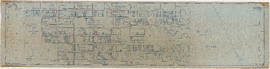
Part is a section depicting the area bounded by Imperial Street to English Bay to the University Endowment Lands to Fifth Avenue. The sheet has been extensively annotated, with colour coded areas to depict land use, status of lots as tax sale properties for sale, sewer and water lines, as well as other colour codes that are not noted on the legend at the front of the volume.

Part of City of Vancouver fonds
Part is a section depicting the area bounded by Trutch Street to English Bay to Imperial Street to Fifth Avenue. The sheet has been extensively annotated, with colour coded areas to depict land use, status of lots as tax sale properties for sale, sewer and water lines, as well as other colour codes that are not noted on the legend at the front of the volume.

Point Grey section F supplementary information
Part of City of Vancouver fonds
Part is a sheet showing assessment and other information relevant to Point Grey section C. The sheet also includes a detail map of the area bounded by [Balaclava Street?] to 16th Avenue to Puget Drive to 19th Avenue

Part of City of Vancouver fonds
Part is a section depicting the area bounded by Trafalgar Street to Sixteenth Avenue to Wallace Street to Twenty-seventh Avenue. The sheet has been extensively annotated, with colour coded areas to depict land use, status of lots as tax sale properties for sale, sewer and water lines, as well as other colour codes that are not noted on the legend at the front of the volume.

Part of City of Vancouver fonds
Part is a section depicting the area bounded by Cambie Street to Sixteenth Avenue to Granville Street to Twenty-seventh Avenue. The sheet has been extensively annotated, with colour coded areas to depict land use, status of lots as tax sale properties for sale, sewer and water lines, as well as other colour codes that are not noted on the legend at the front of the volume.

Point Grey section J supplementary information
Part of City of Vancouver fonds
Part is a sheet with supplementary information in the form of a revised block plan for the are bounded by Crown Street to 27th Avenue to Camosun Street to 29th Avenue.

Part of City of Vancouver fonds
Part is a section depicting the area bounded by Trafalgar Street to Twenty-seventh Avenue to Wallace Street to Thirty-eighth Avenue. The sheet has been extensively annotated, with colour coded areas to depict land use, status of lots as tax sale properties for sale, sewer and water lines, as well as other colour codes that are not noted on the legend at the front of the volume.

Point Grey section L supplementary information
Part of City of Vancouver fonds
Part is a sheet showing assessment and other information relevant to Point Grey section L.

Part of City of Vancouver fonds
Part is a section depicting the area bounded by Queen Elizabeth Park to Twenty-seventh Avenue to Granville Street to Thirty-eighth Avenue. The sheet has been extensively annotated, with colour coded areas to depict land use, status of lots as tax sale properties for sale, sewer and water lines, as well as other colour codes that are not noted on the legend at the front of the volume.

Point Grey section O supplementary information
Part of City of Vancouver fonds
Part is a sheet showing assessment and other information relevant to Point Grey section O.

Part of City of Vancouver fonds
Part is a section depicting the area bounded by Granville Street to Forty-ninth Avenue to Marine Crescent to Sixty-first Avenue. The sheet has been extensively annotated, with colour coded areas to depict land use, status of lots as tax sale properties for sale, sewer and water lines, as well as other colour codes that are not noted on the legend at the front of the volume.
![Habitat [Forum '76]](/uploads/r/null/5/e/b/5ebb9d6644fea2ad2eabe43237d98ec646a50fc33d2742e50e293ae09bd50048/4ea2e50e-c001-40f4-9858-6300c40d91d5-2012-051_142.jpg)
Part of City of Vancouver Archives sound recording and moving image collection
Item is a film showing the site of the Habitat Forum located near Jericho and Locarno Beaches. Film shows views of the North Shore Mountains, construction of structures at the Habitat site, the hangar mural designed by Bill Reid, and people walking around the Habitat site.
First and second post for arch
Part of City of Vancouver Archives sound recording and moving image collection
Item is a film showing the transportation and installation of the wooden logs for the Habitat archway. Film also shows a woman on a bicycle and views of the downtown skyline.
![Arch, Colin & Co. [Habitat Forum '76 - final log]](/uploads/r/null/b/6/4/b64c5a4f286adb8775e0fd3af625dbe0307a7f4f243fe830b2eb2fe754ea0cca/013872af-f864-47e1-9efe-27a011f5c54e-2012-051_142.jpg)
Arch, Colin & Co. [Habitat Forum '76 - final log]
Part of City of Vancouver Archives sound recording and moving image collection
Item is a film showing workers using equipment to lift and install the final log on top of the Habitat archway.

Part of City of Vancouver Archives sound recording and moving image collection
Item is a film containing home movie footage filmed by Allan Crocker. The film shows people playing tennis at Jericho Tennis Club, the exterior features and the view from Jericho Tennis Club. The film also shows Estelle Crocker leaving a retail store and driving a car.
Item is a photograph showing a group of Indigenous people drumming surrounded by onlookers at the Habitat Forum site in Jericho Beach Park.
Vancouver Point Grey : the upset riding
Item outlines the election platform of Hilda Thomas and Paul Sabatino, New Democratic Party candidates for Vancouver - Point Grey.
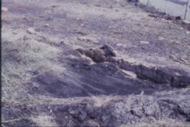
![[Mr. Mark Mount and Mr. McRae felling trees at 3379 West 22nd Avenue]](/uploads/r/null/f/d/fd5ce0f34e09a4e3c969c6465f06fdc7940190913db0503143855fd7ca00f31d/c9b95948-d069-4bb6-ac35-9e438a5593ad-A68664_142.jpg)
[Mr. Mark Mount and Mr. McRae felling trees at 3379 West 22nd Avenue]

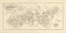
Lot numbers, boundaries, railway lines and street names in the municipality of Point Grey
Part of City of Vancouver Archives technical and cartographic drawing collection
Primary map shows lot numbers, boundaries, railway lines and street names in the municipality of Point Grey from 16th Avenue in the north to the Fraser River in the south and from Ontario Street in the east to Blanca Drive in the west. A smaller map in the bottom left-hand corner of the item shows the north west portion of Point Grey.

Redevelopment plan for Jericho Department of National Defence lands
Part of City of Vancouver Archives technical and cartographic drawing collection
Item is a map showing proposed redevelopment of portions of former Department of National Defence lands in the Jericho area. The map shows existing city parks, D.N.D. lands to be taken over for parks and recreation, city owned land, single family land, town houses, garden apartments and town houses and proposed new roads. The map appears to have been removed from a report.
Vancouver (B.C.). Engineering Services
![[Composite photograph of] Point Grey Police Department [employees]](/uploads/r/null/3/e/3e0e38b5de1085fd12542c874c16e8091aa0722e097503c829dd939b5e43d2d1/35bfd283-4e1c-4884-8ebc-4814f3a3f7d1-A31792_142.jpg)
[Composite photograph of] Point Grey Police Department [employees]
Part of Major Matthews collection
Individuals identified are H.P. McCraney (Police Commissioner), Dr. Blackwood (Police Surgeon), J.Allan (Police Commissioner), J. Birnie, Reeve Lembke (Magistrate), T.F. Johnstone, A. Logan, M. Macaulay, W. Clouston, H.J. Simpson, J. Murdock, J.E. Green, N. McPerson, J. McDonald, P. Kirkham, T. Hurlbert and W.E. Blair
![[Cornerstone ceremony for the Science Building at the University of British Columbia]](/uploads/r/null/6/0/602b0c0c750d78173a4a83aeffbecbd954cc9b966cd7184433bcfbb1938fddc2/01fd38a4-327e-406b-a115-809697c6129e-A24943_142.jpg)
[Cornerstone ceremony for the Science Building at the University of British Columbia]
Part of Major Matthews collection
![[Crowds gathered for opening of Grace Hospital]](/uploads/r/null/6/7/674e3eaa3505606f12b91279aeb48c1396146ff176cba74eca387271d20c1fc1/f8c261b9-8adb-4892-89d7-4fb95b96c87f-A08862_142.jpg)
[Crowds gathered for opening of Grace Hospital]
Part of Major Matthews collection
J.S. Matthews' notes with print or negative in Archives.
![[The remains of two cars after an accident near Granville Street and Connaught Drive]](/uploads/r/null/2/2/2275cb44e0e6e73b63cf2227eec48a95121f1f7fbea0ed46093b6a1e6012c55e/7a2ffaeb-4a04-4f8a-8917-88efcf0cdc21-A37366_142.jpg)
[The remains of two cars after an accident near Granville Street and Connaught Drive]
Part of Major Matthews collection

[Trap shooting at Vancouver Gun Club - Oak Street and 45th Avenue
Part of Major Matthews collection
![[Members of the Terminal City Lawn Bowling Club playing on Christmas Day]](/uploads/r/null/9/0/90d6725f9d1d4f6f3deac4d9e5164c3bc496032aaf8298126c8a724e6a2b7f19/3ca948fe-5700-413c-a43a-1f695f7a0bdd-A36573_142.jpg)
[Members of the Terminal City Lawn Bowling Club playing on Christmas Day]
Part of Major Matthews collection
Photograph shows H.L.M. Stewart and others
Part of Neil Gilchrist fonds
Item is a photograph album showing various scenes of family, friends, classmates, school events, Provincial Normal School boys' and girls' basketball teams, leisure activities, Labour Day parades; geographic areas include around Vancouver and the lower mainland including English Bay and Second Beach, as well as various locations from around the province such as Victoria, Buccaneer Bay, Armstrong, Vernon, Harrison and other sites. The album also includes photographs showing ships and soldiers in uniform from World War I, including Witley Camp, England and Signal Hill in Esquimalt, B.C., including portraits and group photographs.
![[Southern view of Samuel and Fitzgerald McCleery's farms - District Lots 315 and 316]](/uploads/r/null/2/9/e/29e5e2ee1ab72e418f96f7141a35b69a66da2b5808f04d8af443c2fdae390ef2/d22eb2ef-a370-4cc4-99f3-9ddec8fddaf8-LP355_142.jpg)
[Southern view of Samuel and Fitzgerald McCleery's farms - District Lots 315 and 316]
Part of Major Matthews collection
Item consists of 3 photographs mounted on board to form a sectional panoramic view of MacDonald Street (Old Kaye Road)
![Granville Street South at Connaught Drive and 29th [Avenue]](/uploads/r/null/7/d/7d04aac5cb9e9c551e02668ce8b6cb7b9bb83d6748900c612fbab7e51ff8b2c8/aaeeb4b8-b3c0-4ec5-b9e4-9eee6b8b089b-A37189_142.jpg)
Granville Street South at Connaught Drive and 29th [Avenue]
Part of Major Matthews collection
![[Looking west on Buckland Road (West 29th Avenue) from Alma Road (Street)]](/uploads/r/null/0/0/00845954f4d465c43deb4d2e806a6e23524a0dd93df1366dee8518bdfc6da7a4/6293bd29-39c0-4713-951e-7a0ba8a90599-A36986_142.jpg)
[Looking west on Buckland Road (West 29th Avenue) from Alma Road (Street)]
Part of Major Matthews collection
Photograph shows the Convent of the Sacred Heart under construction

Presentation Ceremony to J.M. Chappell Esq. Chairman Point Grey Board of School Trustees
Part of Major Matthews collection
Group portrait showing left to right: (back row): Frank Peace, W.F. Stewart, Dr. Lowrie, Mr. McDonald and C.F. Connor; (front row): Lemuel Robertson, W.J. Twiss, J.M. Chappell and Angus M. Stewart