
- COV-PG-S247-: LEG1153.359
- Item
- Apr. 16, 1923
Part of City of Vancouver fonds
Part of City of Vancouver fonds

Part of City of Vancouver fonds
![General plan - sheet 11 [Arbutus Street to Celtic Avenue to Fraser River]](/uploads/r/null/3/f/d/3fd9a37e7d563f1ab5ea2d9d72418a55895d86310b0a78eab48407b8b835b701/136e3b9b-509e-4f21-94e7-d53135afd227-LEG1153_142.jpg)
General plan - sheet 11 [Arbutus Street to Celtic Avenue to Fraser River]
Part of City of Vancouver fonds

Part of City of Vancouver fonds

Part of City of Vancouver fonds

Point Grey section K supplementary information
Part of City of Vancouver fonds
Part is a sheet showing assessment and other information relevant to Point Grey section K.

Point Grey section S supplementary information
Part of City of Vancouver fonds
Part is a sheet showing assessment and other information relevant to Point Grey section S.

Part of City of Vancouver fonds
Part is a section depicting the area bounded by Marine Crescent to Forty-ninth Avenue to Wallace Street to the Fraser River. The sheet has been extensively annotated, with colour coded areas to depict land use, status of lots as tax sale properties for sale, sewer and water lines, as well as other colour codes that are not noted on the legend at the front of the volume.

Point Grey section X supplementary plans
Part of City of Vancouver fonds
Part is a sheet with supplementary information in the form of a two revised block plans: one for the area bounded by Ash Street to 59th Avenue to Heather Street to 66th Avenue; and the other the bock to the west side of Laurel Street between 64th Avenue and 67th Avenue.

Part of City of Vancouver fonds
Part is a section depicting the area bounded by Ash Street to Fifty-ninth Avenue to Granville Street to Seventy-first Avenue. The sheet has been extensively annotated, with colour coded areas to depict land use, status of lots as tax sale properties for sale, sewer and water lines, as well as other colour codes that are not noted on the legend at the front of the volume.

Part of City of Vancouver fonds
Part is a sheet with two partial sections: one depicting the area bounded by Heather Street to Seventy-second Avenue to Granville Street to the Fraser River; the second depicting the area bounded by Granville Street to Suth-west Marine Drive to Angus Drive to the Fraser River. The maps have been extensively annotated, with colour coded areas to depict land use, status of lots as tax sale properties for sale, sewer and water lines, as well as other colour codes that are not noted on the legend at the front of the volume.

Part of City of Vancouver fonds

Part of City of Vancouver fonds
Item is a photograph showing Aberthau Mansion.

Part of City of Vancouver fonds
Item is a photograph showing Aberthau Mansion.
Part of City of Vancouver fonds

Part of City of Vancouver fonds

Part of City of Vancouver fonds
Part of City of Vancouver fonds
Part of City of Vancouver fonds
Part of City of Vancouver fonds

Part of City of Vancouver fonds
Item is a map showing the railway line from New Westminster to Point Grey. Railway data appears to have been added to a base map showing topographic contour lines, shorelines, low tide marks, natural divides, and municipal boundaries.
![[Chief Turner and Captain Munro of Point Grey Fire Department aboard Fire Chief's automobile]](/uploads/r/null/3/e/5/3e56e5f7a117044aa405bb2770771b159eaa81c0098a98a3b9a0bc8b4ce9b545/a568a13d-a0a2-4bb7-b487-d0ba9f4a08d3-CVA354-047_142.jpg)
[Chief Turner and Captain Munro of Point Grey Fire Department aboard Fire Chief's automobile]
Part of City of Vancouver fonds
Item is a photograph showing Turner in the passenger seat and Munro at the wheel.

Part of City of Vancouver fonds
Item is a photograph showing Chief F. Raymur and Deputy Chief E. Seaford on dais at opening of Point Grey Firehall No. 4 at 70th Avenue and Hudson Street.
![No. 4 Hall P.G.F.D. [Point Grey Fire Department]](/uploads/r/null/1/6/3/1634e7cff884fd88c2cfd881c642857ef4700f10fd3353340a0f8e1e934de17d/b917d413-02c3-4d83-9e38-68d313c69dbe-CVA354-066_142.jpg)
No. 4 Hall P.G.F.D. [Point Grey Fire Department]
Part of City of Vancouver fonds
Item is a photograph showing the opening of Point Grey Firehall No. 4 at 70th Avenue and Hudson Street.

Part of City of Vancouver fonds

Part of City of Vancouver fonds

View of house under construction from Killarney Manor at 2890 Point Grey Road
Part of City of Vancouver fonds
House under construction at 2966 Point Grey Road
Part of City of Vancouver fonds

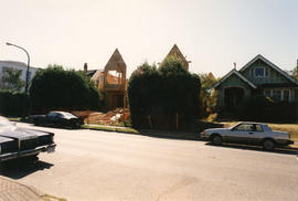
House under construction on 2900 block Point Grey Road
Part of City of Vancouver fonds
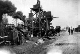
Item is a photograph of an asphalt plant set up beside an unpaved street in Point Grey. Also included are plant operators and a horse cart.

Main library building at U.B.C.

Supper Ride - Southlands Riding Club
Item is a photograph showing a group of riders on horseback at Spanish Banks beach; list of riders provided by donor (L-R): Ronald Grace - sec. treas. Bralorne, Frank Lofting - sec. Neolite Ltd., Franklin K. Collins - lawyer, A. Howard Spohn - physician, Richard Chow, Neina Williams (Mrs. Thomas A.), G.O. Matthews - physician, Lucile Gardiner (Mrs. Harold), T. H. Baird - B.C. Livestock Prod., Jean Bailey - nurse for Dr. Spohn, Peggy Craig, Bob Moberg - student, Nan Hardie - student, Edith Thomson - clerk, B of Mtl., - H. Hind, Joan Gell - student, Polly Howard (Brand), Muriel McNeil - sec. Canada Wire, Peter Sloan - Alaska Pine, Wm. J. Stothers - retired, Winifriede Jackson (Mrs. Geo. F.), Dave Davies - student, Hewitt Hayward - farmer, Robert A. Cuthbert - student, Harry Grainger, W. Margaret Lofting (Mrs. Frank), George F. Jackson - furniture, Irene Strong - student, Winnie Hunter (Mrs. Archibald), Joshua Y. Strong - N. Pacific Export, Alice Bailey, Grace Cuthbert (Mrs. R. G.), Robert G. Cuthbert - vet. surgeon, Daisey MacDougall - mgr. Woman's Bakery, Clive (?) Gray, Bernice Ramsay - clerk, U.I.C., Palmer Rutledge - trailhorse guide, Eleanor Sloan, Dr. J. H. Martyn - vet. surgeon, Nina Fairweather - widow of A. H., E. M. Milligan, Emma Stocker (Mrs. Arthur H.), A. J. "Mac" MacPherson - Pt. Grey Realty, Laurie Kelson - Empire Motors Sales, Marjorie Rowlings, Walter B. Rowlings - H. A. Roberts Ltd., May Eng James - music teacher?, Wm. A Ragsdale - Rand & Fowler Ltd., H. J. Bird - investment dealer

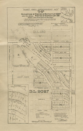
Point Grey, B.C. : district map
Part of City of Vancouver Archives technical and cartographic drawing collection
Item is a flyer or promotional brochure showing proposed zoning districts for the municipality of Point Grey to be created by a proposed zoning by-law. The districts are depicted on the map which makes up the majority of the item. Surrounding the map is the text of the proposed by-law.

Sale of municipal lands : Point Grey : map showing location of lots to be sold
Part of City of Vancouver Archives technical and cartographic drawing collection

Vancouver, British Columbia : south-westerly portion, formerly Point Grey : major street plan
Part of City of Vancouver Archives technical and cartographic drawing collection
Item is a map which has been removed from a copy of the report "A plan for the City of Vancouver, British Columbia, including Point Grey and South Vancouver and a general plan of the region", commissioned by the Vancouver Town Planning Commission from the planning consultants Harland Bartholomew & Associates.
The map shows existing and proposed additions to the major street plan in part of the city that is the former Municipality of Point Grey. The map also shows present street widths, lines of vehicles and roadway widths versus proposed street widths, lines of vehicles and roadway widths.
Harland Bartholomew and Associates

Rezoning application map (Point Grey Road)
Part of City of Vancouver Archives technical and cartographic drawing collection
Item is a map that would have been created to accompany an application for re-zoning for Block 235 D.L. 538 and water lots 5834, 5601 and 5600. It appears that this application failed, as no amendment to By-law 3575 for these properties has been found.
Vancouver (B.C.). Planning Department
![Habitat [Forum '76]](/uploads/r/null/b/0/1/b0129ad1de59431a37bc40fec8687a18e9f4251af6af137243fc20b9389c73de/ce3a6ce0-a604-4e17-988c-f667f763c34b-2012-051_142.jpg)
Part of City of Vancouver Archives sound recording and moving image collection
Item is a film showing the site of the Habitat Forum located near Jericho and Locarno Beaches. Film contains views of the Vancouver skyline, hangar mural designed by Bill Reid, Habitat entrance archway, flags of UN countries, people walking around the Habitat site, a Greenpeace sailboat, wood carving, wooden sculptures and a totem pole.
![Dev funeral and Habitat [Ireland State Funeral, Vancouver Habitat Forum '76 early setup]](/uploads/r/null/1/c/0/1c0c897194e1d6cac453d1f4180c87bdffbab9b91677e913a042398a3b61e3cc/868fe814-ae26-43b8-adb8-8e18fa9d5c8d-2012-051_142.jpg)
Dev funeral and Habitat [Ireland State Funeral, Vancouver Habitat Forum '76 early setup]
Part of City of Vancouver Archives sound recording and moving image collection
Item is a film showing scenes from a funeral procession [possibly in Ireland], blurry shots of a television screen, a house on a coastal cliff and the ocean, views of the North Shore Mountains from the Habitat grounds at dawn, hangars and lumber at Habitat grounds prior to setup of Habitat.

Cecil Green Park house, dining room fireplace
Part of Art Grice fonds
![["Braeriach" the Davidson residence at 2119 West 42nd Avenue]](/uploads/r/null/4/e/4ec27bf41906a9bab7fbc57b043c692b8bf5af1366f9fd4bfdeec52d26980f60/d1ee1d28-b246-4c83-a2fc-bca7d12e60ad-A49927_142.jpg)
["Braeriach" the Davidson residence at 2119 West 42nd Avenue]
Part of John Davidson fonds
Photograph shows the women and girls of the Davidson family on the front steps
![[A women and child in the backyard of 2119 West 42nd Avenue]](/uploads/r/null/0/b/0b87719fd16e35d6beffbbcbd339eab40ace50f9bd77908390e02c755bcae7ce/2851b205-4a90-4c0f-9604-c79fc2383f26-A50235_142.jpg)
[A women and child in the backyard of 2119 West 42nd Avenue]
Part of John Davidson fonds
Photograph shows the rear of the Bowser Block on West 41st Avenue
![[Annie Davidson]](/uploads/r/null/0/7/07896b2d6b25ca41909472cc852279f787116037090b289f5d8b8c69a0d1b833/e4d7d7c7-09ad-46ef-b38b-497b6b94ba55-A50535_142.jpg)
Part of John Davidson fonds
Head and shoulders portrait
![[Blasting stumps in Kerrisdale]](/uploads/r/null/1/7/17328b8b3a5a8eaaf6a9241fbd451cfc5d3bbaaa431f679e8081d56822b06ff3/caef93e2-aeda-4a66-b113-43eae07b06f7-A50233_142.jpg)
[Blasting stumps in Kerrisdale]
Part of John Davidson fonds
![[Interior of Kerrisdale Baptist Church at 5870 East Boulevard]](/uploads/r/null/6/e/6ef18ffb2b2a29999b9319fc7de87925c8b3da6f67c7deadbdb10bdb7dfa23c3/222ac89a-ed72-44f8-8664-09e9e663e5f6-A50818_142.jpg)
[Interior of Kerrisdale Baptist Church at 5870 East Boulevard]
Part of John Davidson fonds
![[Jean and Jack Davidson playing in yard at 2119 West 42nd Avenue]](/uploads/r/null/a/5/a5dec41ebd2a535a4ff06f572fcf1e6b1f20f9e0507ac8fd10a573df85228f64/54ff2b8f-baa8-4da5-accc-c1f0cca3e9f8-A50246_142.jpg)
[Jean and Jack Davidson playing in yard at 2119 West 42nd Avenue]
Part of John Davidson fonds
Photograph shows the Kerrisdale Bakery and Kerrisdale Sheet Metal Works in the background
![[Jean and Jack Davidson]](/uploads/r/null/6/9/6920379c396c90db024f0d40ff50ac52761c59e89e19736497b55926f82a5424/72c34b64-1966-4881-b736-a1fc7655219b-A49948_142.jpg)
Part of John Davidson fonds
Photograph shows Jean wearing an M.S. Grampian hat
![[Jean Davidson]](/uploads/r/null/7/f/7f58b68638df1db2ea78d66f1978ed5c356c54ecd116d8769fd0def744d06b45/65b124da-0891-40fb-8d8f-75c366d9bf93-A50537_142.jpg)
Part of John Davidson fonds
Head and shoulders portrait
![[Kerrisdale Baptist Church at 5870 East Boulevard]](/uploads/r/null/6/7/6740fd3a1da1a9a0bd3c8cc95c54cfa6eede1e8fc8b5e6911010459f4052fee0/78d908db-1a8c-4af7-a4cf-8ab3d4ff2647-A50821_142.jpg)
[Kerrisdale Baptist Church at 5870 East Boulevard]
Part of John Davidson fonds
![[Point Grey Municipal Hall and grounds]](/uploads/r/null/7/d/7da87dc32f919bfb829014c8c01f7dd2413a790ee2a29c54aba6377788069606/eb2fdad9-4fb8-477b-bbb5-27cff4791480-A50234_142.jpg)
[Point Grey Municipal Hall and grounds]
Part of John Davidson fonds
![[The Suburb De Luxe 1908-1920 float]](/uploads/r/null/c/e/ce9fbf1fe91340bb5675eec1be4575bf36170fae71d70efe1432f2b86f357515/5ed683db-e5e7-47fc-9b6c-a05a9e4f44bd-A50817_142.jpg)
[The Suburb De Luxe 1908-1920 float]
Part of John Davidson fonds
Photograph shows a float decorated with plants and flowers with the compliments of Point Grey