
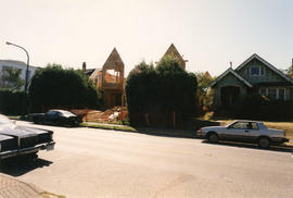
View of house under construction from Killarney Manor at 2890 Point Grey Road
- COV-S62-4---: CVA 296-166
- Item
- 1994
Part of City of Vancouver fonds
View of house under construction from Killarney Manor at 2890 Point Grey Road
Part of City of Vancouver fonds
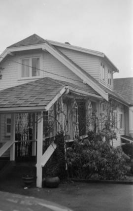
House under construction at 2966 Point Grey Road
Part of City of Vancouver fonds

House under construction on 2900 block Point Grey Road
Part of City of Vancouver fonds

Part of City of Vancouver fonds

Part of City of Vancouver fonds
![General plan - sheet 11 [Arbutus Street to Celtic Avenue to Fraser River]](/uploads/r/null/3/f/d/3fd9a37e7d563f1ab5ea2d9d72418a55895d86310b0a78eab48407b8b835b701/136e3b9b-509e-4f21-94e7-d53135afd227-LEG1153_142.jpg)
General plan - sheet 11 [Arbutus Street to Celtic Avenue to Fraser River]
Part of City of Vancouver fonds

Part of City of Vancouver fonds

Part of City of Vancouver fonds
![[Chief Turner and Captain Munro of Point Grey Fire Department aboard Fire Chief's automobile]](/uploads/r/null/3/e/5/3e56e5f7a117044aa405bb2770771b159eaa81c0098a98a3b9a0bc8b4ce9b545/a568a13d-a0a2-4bb7-b487-d0ba9f4a08d3-CVA354-047_142.jpg)
[Chief Turner and Captain Munro of Point Grey Fire Department aboard Fire Chief's automobile]
Part of City of Vancouver fonds
Item is a photograph showing Turner in the passenger seat and Munro at the wheel.

Part of City of Vancouver fonds
Item is a photograph showing Chief F. Raymur and Deputy Chief E. Seaford on dais at opening of Point Grey Firehall No. 4 at 70th Avenue and Hudson Street.
![No. 4 Hall P.G.F.D. [Point Grey Fire Department]](/uploads/r/null/1/6/3/1634e7cff884fd88c2cfd881c642857ef4700f10fd3353340a0f8e1e934de17d/b917d413-02c3-4d83-9e38-68d313c69dbe-CVA354-066_142.jpg)
No. 4 Hall P.G.F.D. [Point Grey Fire Department]
Part of City of Vancouver fonds
Item is a photograph showing the opening of Point Grey Firehall No. 4 at 70th Avenue and Hudson Street.

Part of City of Vancouver fonds

Part of City of Vancouver fonds
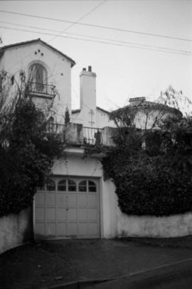
Item is a photograph showing Aberthau Mansion.

Part of City of Vancouver fonds
Item is a photograph showing Aberthau Mansion.
Part of City of Vancouver fonds

Part of City of Vancouver fonds

Part of City of Vancouver fonds
Part of City of Vancouver fonds
Part of City of Vancouver fonds

Part of City of Vancouver fonds

Part of City of Vancouver fonds
Part of City of Vancouver fonds

Part of City of Vancouver fonds
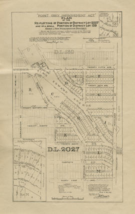
Item is a map showing the railway line from New Westminster to Point Grey. Railway data appears to have been added to a base map showing topographic contour lines, shorelines, low tide marks, natural divides, and municipal boundaries.

Point Grey section K supplementary information
Part of City of Vancouver fonds
Part is a sheet showing assessment and other information relevant to Point Grey section K.

Point Grey section S supplementary information
Part of City of Vancouver fonds
Part is a sheet showing assessment and other information relevant to Point Grey section S.

Part of City of Vancouver fonds
Part is a section depicting the area bounded by Marine Crescent to Forty-ninth Avenue to Wallace Street to the Fraser River. The sheet has been extensively annotated, with colour coded areas to depict land use, status of lots as tax sale properties for sale, sewer and water lines, as well as other colour codes that are not noted on the legend at the front of the volume.

Point Grey section X supplementary plans
Part of City of Vancouver fonds
Part is a sheet with supplementary information in the form of a two revised block plans: one for the area bounded by Ash Street to 59th Avenue to Heather Street to 66th Avenue; and the other the bock to the west side of Laurel Street between 64th Avenue and 67th Avenue.

Part of City of Vancouver fonds
Part is a section depicting the area bounded by Ash Street to Fifty-ninth Avenue to Granville Street to Seventy-first Avenue. The sheet has been extensively annotated, with colour coded areas to depict land use, status of lots as tax sale properties for sale, sewer and water lines, as well as other colour codes that are not noted on the legend at the front of the volume.

Part of City of Vancouver fonds
Part is a sheet with two partial sections: one depicting the area bounded by Heather Street to Seventy-second Avenue to Granville Street to the Fraser River; the second depicting the area bounded by Granville Street to Suth-west Marine Drive to Angus Drive to the Fraser River. The maps have been extensively annotated, with colour coded areas to depict land use, status of lots as tax sale properties for sale, sewer and water lines, as well as other colour codes that are not noted on the legend at the front of the volume.
![[Convent of the Sacred Heart, Marine Heights, Point Grey, B.C. later St. George's School]](/uploads/r/null/8/2/826c4f05379118e8c24b4fb2dd2e5330c763b9455307b8c9b2db854eb484b9e0/5b5413d5-8b07-4cea-a4d3-2615adb6b50f-A70548_142.jpg)
[Convent of the Sacred Heart, Marine Heights, Point Grey, B.C. later St. George's School]
Part of St. George's School fonds
Photograph shows a wooden sidewalk

Crowd with umbrellas gathered around stage at dedication of Volunteer Park

Group on stage at dedication of Volunteer Park
Item is a photograph showing a group on stage at the dedication of Volunteer Park. Mike Harcourt is pictured speaking into microphone. Michael Francis is shown to the left of Tillicum behind podium.
![Gywn [Lewis]'s birthday party on the beach at P[oin]t Grey](/uploads/r/null/2/b/0/2b0cc964c3af3caf6ae37f3149f74d6356d5e61c509b99adc1b43e98bf3ead98/7e8366e2-c3c3-413e-a44a-e030247caddd-CVA289-003_142.jpg)
Gywn [Lewis]'s birthday party on the beach at P[oin]t Grey
Part of William Orson Banfield fonds
Part of William Orson Banfield fonds


![Morning under Point Grey [view of shoreline and downtown buildings in the distance]](/uploads/r/null/2/f/1/2f141748414f4696f19f2598cae139f425f9b807cbe7ce99510048b663ba66ea/9d927529-65a8-4ec4-b61a-2685d3a0aa70-CVA293-091_142.jpg)
Morning under Point Grey [view of shoreline and downtown buildings in the distance]
![Morning under Point Grey [view of shoreline and downtown buildings in the distance]](/uploads/r/null/a/c/c/accfb817ca5542dfee36ec72a3674496c03bd81838863832d1690e51f50befd7/23e750f8-09c6-4b8d-9169-4827db75ba88-CVA293-091_142.jpg)
Morning under Point Grey [view of shoreline and downtown buildings in the distance]
![Range on Wreck Beach [low tide]](/uploads/r/null/0/a/5/0a512f4f9485d1a83f1d55dba747ade57a8398a93d52ae2b8e93048c221d83bb/3c3104ef-6bc9-4afa-89ed-da2cfa1e705b-CVA293-165_142.jpg)
Range on Wreck Beach [low tide]
![Range on Wreck Beach [low tide]](/uploads/r/null/0/f/a/0fae513385181b90a03454bd0a046c92f57e42ba39f2d38800ee77bbfe6a01e8/4e54d145-5904-4aba-be67-2653decbedf8-CVA293-165_142.jpg)
Range on Wreck Beach [low tide]
![On the beach at Point Grey : John [Banfield]](/uploads/r/null/d/8/6/d866e1427598481f43c9228347ffc687985839f3382fa9148b7a63c9b4b178cf/e2b37143-244e-4012-b782-b5dfb36fc1d3-CVA289-005_142.jpg)
On the beach at Point Grey : John [Banfield]
Part of William Orson Banfield fonds
![On the beach at Point Grey : Jane [Banfield]](/uploads/r/null/6/8/9/6895b418a59577dafac725bbc3b4d8096babf78c2ec7bc646aef5b025b100866/f30b4516-e4e9-4923-8ec0-64592e75f09f-CVA289-005_142.jpg)
On the beach at Point Grey : Jane [Banfield]
Part of William Orson Banfield fonds
![G. Fountain, Pt. Grey [U.B.C. student]](/uploads/r/null/6/3/a/63a313b9c8bcabf38c987bc5922819bb029844a1b9b9408d22d7893d0213d34a/05a7c336-d650-4393-a380-bd636de9245b-CVA289-006_142.jpg)
G. Fountain, Pt. Grey [U.B.C. student]
Part of William Orson Banfield fonds

Sale of municipal lands : Point Grey : map showing location of lots to be sold
Part of City of Vancouver Archives technical and cartographic drawing collection

Vancouver, British Columbia : south-westerly portion, formerly Point Grey : major street plan
Part of City of Vancouver Archives technical and cartographic drawing collection
Item is a map which has been removed from a copy of the report "A plan for the City of Vancouver, British Columbia, including Point Grey and South Vancouver and a general plan of the region", commissioned by the Vancouver Town Planning Commission from the planning consultants Harland Bartholomew & Associates.
The map shows existing and proposed additions to the major street plan in part of the city that is the former Municipality of Point Grey. The map also shows present street widths, lines of vehicles and roadway widths versus proposed street widths, lines of vehicles and roadway widths.
Harland Bartholomew and Associates

Rezoning application map (Point Grey Road)
Part of City of Vancouver Archives technical and cartographic drawing collection
Item is a map that would have been created to accompany an application for re-zoning for Block 235 D.L. 538 and water lots 5834, 5601 and 5600. It appears that this application failed, as no amendment to By-law 3575 for these properties has been found.
Vancouver (B.C.). Planning Department
![[View of industrial plants in Marpole]](/uploads/r/null/e/3/e3364eb07307bbf139590b9edd42a7f75ef1e893f2017baef60f68943fb2b3cb/8227b06a-c2b5-4539-916f-a62b31a65ee7-A62155_142.jpg)
[View of industrial plants in Marpole]
Part of Major Matthews collection
![[View of the 500 Block West 19th Avenue looking west from Tupper Street]](/uploads/r/null/8/f/8f6f821ef7bf46d67609c53bf6c8c225a568e4e77bd8e643d55462a563d466c2/1cfb2430-ad44-4fa8-b2e7-0cd1997c6b1c-A41407_142.jpg)
[View of the 500 Block West 19th Avenue looking west from Tupper Street]
Part of Major Matthews collection
![[Sewer construction on Balsam Street between Wilson Road (41st Avenue) and 43rd Avenue]](/uploads/r/null/c/7/c74ae55486e09a12925420883018ca42e279126e8d1b632697938151ae39ccc9/57c59201-e33b-44e8-b36c-b74b4dff24bc-A61288_142.jpg)
[Sewer construction on Balsam Street between Wilson Road (41st Avenue) and 43rd Avenue]
Part of Major Matthews collection
![[Boys Industrial School camp at Spanish Banks]](/uploads/r/null/1/1/111b29c0bca8396e1baf83a842b43b2b2ae1baf43e4bdd6c7abcd4dbbf062500/36adfd22-325e-4616-b927-414f33a9673a-A60344_142.jpg)
[Boys Industrial School camp at Spanish Banks]
Part of Major Matthews collection