- AM1257-S26-F23-16
- File
- [195-]
Showing 43 results
Archival description10 results with digital objects Show results with digital objects
Bellingham sectional aeronautical map (Fraser Mills, B.C.)
- AM1257-S26-F23-1
- File
- 1954 (revised to 1965)
- AM1257-S26-F24-5
- File
- 1962 (revised to 1964)
- AM1257-S26-F24-3
- File
- 1962
- AM1257-S26-F24-7
- File
- 1957-1969
British Columbia : controlled access highways
- AM1257-S26-F24-1
- File
- 1957 (revised to 1969)
British Columbia : population distribution, 1961
- AM1257-S26-F24-4
- File
- 1961
British Columbia land recording districts
- AM1257-S26-F24-6
- File
- 1967
British Columbia, school districts
- AM1257-S26-F24-8
- File
- 1957

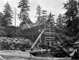
Burwell Lake, stream outlet from Burwell Lake before Dam was started
- AM1257-S25-: CVA 275-30
- Item
- 1919-09
![Burwell Lake, view N[orth. W[est]. [north east?] along Dam face showing lake at its original wate...](/uploads/r/null/5/1/512924ce9846db6e812b5cd4146af1b202a8bf36b1f63f48d1666f0f3d6255b8/c56c1672-36d7-465d-afb4-dcc7bd262245-CVA275-28_142.jpg)
- AM1257-S25-: CVA 275-28
- Item
- 1925-10

Burwell Lake, view of Crib Dam looking north
- AM1257-S25-: CVA 275-25
- Item
- Mar. 5, 1926
Burwell Lake, view of Dam face after completion of repairs
- AM1257-S25-: CVA 275-27
- Item
- 1925-10
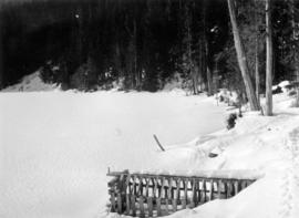
Burwell Lake, view of lake north side from Spillway
- AM1257-S25-: CVA 275-26
- Item
- Mar. 6, 1926
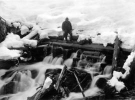
Burwell Lake, view of Spillway Dam showing leaks
- AM1257-S25-: CVA 275-24
- Item
- Mar. 4, 1926
![Burwell Lake, view S[outh]. E[ast]. Along east shore of lake](/uploads/r/null/3/1/3151c8f33bc846f38da75ad100fc9be75a2c332d02c5769fd4431e74fb66bc89/0760f179-f6b4-43e4-915a-2947d9e55355-CVA275-29_142.jpg)
Burwell Lake, view S[outh]. E[ast]. Along east shore of lake
- AM1257-S25-: CVA 275-29
- Item
- 1925-10
- AM1257-S26-F23-17
- File
- [193-]
- AM1257-S26-F23-6
- File
- 1930
Cheakamus power survey : proposed outlet tunnel, Cheakamus Lake
- AM1257-S26-F23-10
- File
- 1930
Cheakamus power survey for the City of Vancouver
- AM1257-S26-F23-3
- File
- 1930-1931
Cheakamus power survey, proposed dam site Cheakamus Lake
- AM1257-S26-F23-8
- File
- 1930
Cheakamus power survey…damsite in Cheakamus Canyon
- AM1257-S26-F23-19
- File
- 1930
Cheakamus River system hydro-electric survey
- AM1257-S26-F23-9
- File
- 1930-1931
Cheakamus runoff at Mons Station
- AM1257-S26-F23-14
- File
- 1930
Cross-section of high damsite near mile 20
- AM1257-S26-F23-12
- File
- [196-]
Discharge in Acre Feet, Stony Creek
- AM1257-S26-F23-7
- File
- 1924-1930
Fragment of sketch survey map of portion of an unidentified river (Cheakamus?)
- AM1257-S26-F23-20
- File
- [193-]
- AM1257-S26-F23-23
- File
- 1973
Geological map of British Columbia
- AM1257-S26-F24-2
- File
- 1948
Geological map units and localities
- AM1257-S26-F25-1
- File
- [196-]
- AM1257-S26-F23-4
- File
- 1918
Greater Vancouver - area within 35 miles
- AM1257-S26-F23-22
- File
- [195-]
Hydro-electric surveys : Cheakamus River from Squamish River to Brandywine Creek
- AM1257-S26-F23-5
- File
- 1923
![[Logging railway line through Watershed district]](/uploads/r/null/4/5/45eb3a42dead444dbef6ddc679ad042f8de7b61408cff56b0db8983ce78e5dbb/5983572e-5753-4709-9242-9737dd6c6037-CVA275-22_142.jpg)
[Logging railway line through Watershed district]
- AM1257-S25-: CVA 275-22
- Item
- Mar. 31, 1922
![[Logging railway line through Watershed district]](/uploads/r/null/5/b/5b102ce6f5fa1892b55b946c6c497be2880fc9e76764354508f0b99ee60fd333/4948c845-8729-4234-a046-dc9a427274b1-CVA275-21_142.jpg)
[Logging railway line through Watershed district]
- AM1257-S25-: CVA 275-21
- Item
- Mar. 31, 1922
![[Logging, clearing in the Watershed district]](/uploads/r/null/8/6/8640647f4ed3ed89b7b5b98661382289a848830db9f61bae861b6781520bb7b9/614c9573-5445-44b9-956d-4388aebfcbd0-CVA275-23_142.jpg)
[Logging, clearing in the Watershed district]
- AM1257-S25-: CVA 275-23
- Item
- Mar. 31, 1922
- AM1257-S26-F23-13
- File
- [193-]
Proposed storage reservoir at Daisy Lake
- AM1257-S26-F23-11
- File
- 1930
Rough sketch of gravel and sand flats at Mile 19.2 (Cheakamus River canyon?)
- AM1257-S26-F23-18
- File
- [193-]
- AM1257-S26-F23-2
- File
- 1969
Sechelt Forest and surrounding area
- AM1257-S26-F23-25
- File
- 1973
- AM1257-S26-F23-24
- File
- 1973
Two unidentified profile sketches (Cheakamus River?)
- AM1257-S26-F23-15
- File
- [196-]