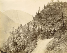
![China Bar Bluff - 28 miles above Yale on the Frazer [Fraser] River](/uploads/r/null/e/9/e9834f1ddcca28563493687bbfecb9567f9ba986b5c202f487df6365406543dc/a92c2367-8f8d-4de3-bbe6-978a47016230-A22918_142.jpg)
China Bar Bluff - 28 miles above Yale on the Frazer [Fraser] River
- AM54-S4-1-A-6-: A-6-172
- Item
- [between 1866 and 1870]
Part of Major Matthews collection
Photograph shows the cribbing supports for the "Waggon" [wagon] Road
92 results with digital objects Show results with digital objects
China Bar Bluff - 28 miles above Yale on the Frazer [Fraser] River
Part of Major Matthews collection
Photograph shows the cribbing supports for the "Waggon" [wagon] Road
![Jack Ass Mountain - Frazer [Fraser] River](/uploads/r/null/c/7/c799a52649bb38a3bcb71ffb75a27c759ff6e8af804f850054196225049c2dd6/17f7922c-c502-4b65-aa24-6d977ba5cf71-A22919_142.jpg)
Jack Ass Mountain - Frazer [Fraser] River
Part of Major Matthews collection
Photograph shows donkey-drawn covered wagons
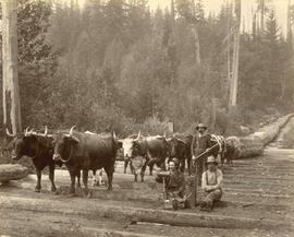
Logging Scene near Vancouver, B.C.
Photograph shows a team of oxen hauling logs on a skid road

Illecillewaet River and C.P.R.
Part of Richard H. Trueman fonds

Pacific Highway and Old Yale Road
Part of Major Matthews collection
Photograph shows a Ruddy-Duker Company billboard advertising Cross's Ginger Ale

Part of Major Matthews collection
![Pacific Highway 300 feet west [of] Old Yale Road](/uploads/r/null/c/5/c5d2a69a5eacd4dff218b51a943a6e13d12ff2d2925de6b8b2353bbc1f275bf7/04cb108c-f7b2-4f71-9a92-3bcc8622a8d8-A20203_142.jpg)
Pacific Highway 300 feet west [of] Old Yale Road
Part of Major Matthews collection

Part of Major Matthews collection
Photograph shows a gravel road with three men in an open car in the background on Vancouver Island

Pacific Highway north side east of Grosvenor Road incoming
Part of Major Matthews collection
Photograph shows a billboard advertising The York Hotel

Pacific Highway and gravel pit
Part of Major Matthews collection
Photograph shows two billboards advertising Church's Shoes and Ingledew's, and Hotel Russell (partly obscured)
![Pacific Highway 1/2 mile east of Port Man Road [on] south side outgoing](/uploads/r/null/c/c/cc0f27c11e681d69fabaf913213a731ca3e82c18a992ecd78fa5177d8a1444dc/ab8fa803-170e-4eff-b798-dc43dbc4d86b-A20208_142.jpg)
Pacific Highway 1/2 mile east of Port Man Road [on] south side outgoing
Part of Major Matthews collection
Photograph shows a billboard advertising Qualicum Beach Hotel and a sign on the roof of a barn for Hall Bros. Garage
![Pacific Highway 1/4 mile east [of] Port Mann Road south side incoming](/uploads/r/null/5/f/5fb1ed3749253c0735d7dd7b762833f8c95b1c95ab682c00bc0bd8ddb1046be9/916b884d-3179-4e97-afb6-21dd752ae588-A20211_142.jpg)
Pacific Highway 1/4 mile east [of] Port Mann Road south side incoming
Part of Major Matthews collection
Photograph shows an empty billboard frame and an Airways Farm Produce road side stand
![Pacific Highway 100 feet from customs [on] south side [of] highway incoming](/uploads/r/null/a/f/af88bd268467cecf5481dcfad3022a009fb6db54d9397bb13afa112719ecf0d6/add49f39-7ef3-43d1-9fac-39c9c6df7102-A20194_142.jpg)
Pacific Highway 100 feet from customs [on] south side [of] highway incoming
Part of Major Matthews collection
Photograph shows a Harry Duker Company billboard advertising B.C. Rye and Old Colonel Bourbon and a Welcome sign for the Auto Club of B.C. showing the speed limits for highways and cities
![Pacific Highway 1/4 mile west of bridge [on] north side incoming](/uploads/r/null/7/7/77cef5933a207fc8fa97f8f449ce69e5e2cfaba97444080837a18d1e7ccf6e78/cd3b0660-360d-429c-9d16-cbef4f1c592d-A20212_142.jpg)
Pacific Highway 1/4 mile west of bridge [on] north side incoming
Part of Major Matthews collection
Photograph shows a billboard advertising the Trocadero Cafe and National Lunch
![Pacific Highway 1/4 mile from Campbell River Road [on] south side [of] highway incoming](/uploads/r/null/7/a/7ae95b4391a64ffb1a2723a38dca7f3931a637cbc96cb96059c983c0ee38c53b/5a12578b-5cd7-4ff7-a5a6-04c5b9a01ebb-A20195_142.jpg)
Pacific Highway 1/4 mile from Campbell River Road [on] south side [of] highway incoming
Part of Major Matthews collection
Photograph shows a Ruddy-Duker Company billboard advertising Church's Shoes and Ingledew's
![Pacific Highway [near] Kiwanis Arch incoming](/uploads/r/null/7/4/740f967d044d90fc31e2655a25833263cd9fde65ce403301ec4765502272f3c8/4bc1b63a-0aaf-472a-b560-3fd7c025abd3-A20196_142.jpg)
Pacific Highway [near] Kiwanis Arch incoming
Part of Major Matthews collection
Photograph shows a Ruddy-Duker Company billboard advertising David Spencer Ltd.
![Pacific Highway 1/2 mile west [of] Fry's Corner north side [of] highway incoming](/uploads/r/null/4/5/454e8bdb8641bb8368fb91775c999548ddcaadaf1d14d0db82d2fce29425be93/d28dac7a-1bd7-4b7e-87d2-c21c08abfc8e-A20197_142.jpg)
Pacific Highway 1/2 mile west [of] Fry's Corner north side [of] highway incoming
Part of Major Matthews collection
Photograph shows a billboard advertising Goodyear, a sign on a barn advertising Vancouver Motors Ltd. and a sign for Electro Magnetism Health Restorer

Pacific Highway at Serpentine River incoming
Part of Major Matthews collection
Photograph shows two Ruddy-Duker Company billboarda advertising spark plugs and oil filters, and David Spencers and a sign on a barn advertising Vancouver Motors Ltd.
![Pacific Highway one mile west of Fry's Corner [on] south side incoming](/uploads/r/null/2/7/275fdfd1b79050d3fd150ffa3b42128cac4a4c29625d96ef9da71cd1c993cdea/5e6f3190-b803-48c0-a837-b34d710aae8c-A20199_142.jpg)
Pacific Highway one mile west of Fry's Corner [on] south side incoming
Part of Major Matthews collection
Photograph shows a billboard for the Devonshire Apartment Hotel

Pacific Highway and Meridian Road
Part of Major Matthews collection
Photograph shows a Ruddy-Duker Company billboard advertising oil filters and signs for: Quaker State Motor Oil, the Trocadero Cafe and the New Your Fur Company

Pacific Highway and Old Yale Road incoming
Part of Major Matthews collection
Photograph shows a Ruddy-Duker Company billboard advertising David Spencer Ltd.
![[Unidentified country road]](/uploads/r/null/5/c/5cdb6addea70b0016a3becf034bab63e9cfb506425b6487c87125755681b518e/c4ea00bb-9214-4677-b68f-1bc501f0c362-A76160_142.jpg)
Part of James Crookall fonds
![[A railroad above a wagon road]](/uploads/r/null/5/6/1/5611125c0239a28ff429071c5e373a96c8c7e60a5ed0520f7f7594edb46a3bb0/7f3cef61-3a82-47d1-b07e-ccb3db87617d-CVA260-1111_142.jpg)
[A railroad above a wagon road]
Part of James Crookall fonds
![[Unidentified village]](/uploads/r/null/3/f/3f2c9828a7def93106f2406a5b93846bc1f53ddf4835f3d91a7675481e5681e2/87ed202e-72d1-4ee2-a125-5342186c6eae-A75641_142.jpg)
Part of James Crookall fonds
![[A road in an unidentified village]](/uploads/r/null/2/a/2a62fee9a3a0bd1952ea3587efaae0ffd78bfd4b683c1053518af566911b05a0/9ef051ec-fd46-44b1-8227-b0824b82ec81-A75649_142.jpg)
[A road in an unidentified village]
Part of James Crookall fonds
![[View of an unidentified village]](/uploads/r/null/8/0/80f32565bc39a9168ba8e22484e6c5f16903014f7de2b56cbf8e7293ee508b3a/92ab7e27-91ab-4879-ab49-80ebd325feff-A75650_142.jpg)
[View of an unidentified village]
Part of James Crookall fonds
Photograph shows a windmill
![[View of an unidentified church at the end of a fenced road]](/uploads/r/null/2/e/2e5e4b890989549829f8915f13d5ae6644929814ca4e5aab06019a07e31063b0/1116984d-6513-458c-a065-81773787829e-A75652_142.jpg)
[View of an unidentified church at the end of a fenced road]
Part of James Crookall fonds
![[A flock of sheep on a road]](/uploads/r/null/4/c/4c35dfa63b453788d49d2f4fbec6b7a5e2d7b3eec4dfd0430ef281aa92852ef9/e40b70cd-e71e-4814-85d9-3a3ec00c7aeb-A75653_142.jpg)
Part of James Crookall fonds
![[View of an unidentified church]](/uploads/r/null/8/f/8f7086c142143893e968d76ad28c832cb4e802ea482b4275ca883e3c699fafb6/da9a5b8c-6a98-4d65-905e-2daca4ca1050-A75654_142.jpg)
[View of an unidentified church]
Part of James Crookall fonds
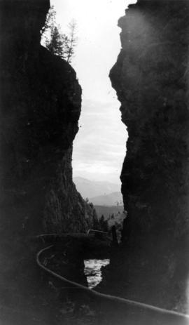
Board of Trade trip, Okanagan and Kootenays : The gateway to Sinclair Canyon
Part of William Orson Banfield fonds

The tunnels on the Cariboo Hiway
Part of William Orson Banfield fonds

Part of William Orson Banfield fonds
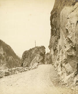
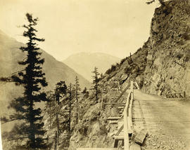
![Wagon Road looking down [Fraser River]](/uploads/r/null/d/3/d31f33f3f68e921c25dc34269c92a6bbaa05550c337ff84c66b4e5640adc5d0d/6dbaba4f-967d-4271-857e-3299e25f0212-A19680_142.jpg)
Wagon Road looking down [Fraser River]
Nicaragua Bluff 13 1/2 miles above Yale

Nicaragua Bluff and wagon road from west side of Fraser River
Trail over the big tunnel 15 miles above Yale
Photograph shows a pack-horse train

Summit of road over Jackass Mountain 48 miles above Yale
Descent from the summit of road over Jackass Mountain
Photograph shows donkey-drawn covered wagons
Wagon road over Jackass Mountain

Great Bluff on the Thompson River
Photograph shows donkey-drawn covered wagons at 8 Mile Bluff

Steffens-Colmer notebook identifies photograph as "Highway near Langley. Mount Baker".


Car on Malahat Drive, Vancouver Island, B.C.
![[Automobiles on] Malahat Drive near Goldstream, Vancouver Island](/uploads/r/null/5/4/5431837b90d22dc90e77f9dbb870535564878bb70ee04a1f5ee212fb5a2e67fa/ef280b1f-7b52-4dcd-8369-b9399d585cac-A06878_142.jpg)
[Automobiles on] Malahat Drive near Goldstream, Vancouver Island

Island Highway near Goldstream

Island highway near Goldstream, Vancouver Island

Cathedral Grove, Vancouver Island
![Hope Highway [in] Fraser Canyon](/uploads/r/null/4/0/40bb356c124801d1912cc9c037c3952de621689d23444062504a05c015764109/4bc547c0-4c08-43c3-a0a3-f23aa9cd2083-A14539_142.jpg)
Hope Highway [in] Fraser Canyon
![[Road and buildings beside] waterfront at Pacific Mills [on the] Queen Charlotte Islands](/uploads/r/null/b/9/b991cfa0013c25630230f938b9a1bf0922b20fa9d8ee1b7c38058d9622d13966/aba7dd2c-ff59-4945-acc6-f878b63fdf12-A14919_142.jpg)
[Road and buildings beside] waterfront at Pacific Mills [on the] Queen Charlotte Islands
![Old Cariboo Trail [and] C.N.R. tracks [near Chapmans (Hope), B.C.]](/uploads/r/null/c/d/cd0a2baae57d70fc460782957d0c59abe7ffda5b367b65a6d55149656409f2e7/8056d3ad-7a2e-4251-b9cb-81b9e6d04585-A14971_142.jpg)
Old Cariboo Trail [and] C.N.R. tracks [near Chapmans (Hope), B.C.]
Photograph shows a direction sign pointing to the "Cariboo Road built 1850"
Inscription on negative envelope "Old Cariboo stagecoach road on mainline of Canadian National Rlys in Fraser Valley near Hope, B.C. - Note from print "