Showing 43 results
Archival description10 results with digital objects Show results with digital objects
Geological map units and localities
Geological map units and localities
British Columbia, school districts
British Columbia, school districts
British Columbia
British Columbia
British Columbia land recording districts
British Columbia land recording districts
Boundaries of Indian agencies
Boundaries of Indian agencies
British Columbia : population distribution, 1961
British Columbia : population distribution, 1961
British Columbia
British Columbia
Geological map of British Columbia
Geological map of British Columbia
British Columbia : controlled access highways
British Columbia : controlled access highways
Cheakamus River system hydro-electric survey
Cheakamus River system hydro-electric survey
Cheakamus power survey, proposed dam site Cheakamus Lake
Cheakamus power survey, proposed dam site Cheakamus Lake
Discharge in Acre Feet, Stony Creek
Discharge in Acre Feet, Stony Creek
Cheakamus power survey
Cheakamus power survey
Hydro-electric surveys : Cheakamus River from Squamish River to Brandywine Creek
Hydro-electric surveys : Cheakamus River from Squamish River to Brandywine Creek
Government reserves
Government reserves
Cheakamus power survey for the City of Vancouver
Cheakamus power survey for the City of Vancouver
Sechelt Forest and surrounding area
Sechelt Forest and surrounding area
Sechelt Inlet
Sechelt Inlet
Garabaldi Park
Garabaldi Park
Greater Vancouver - area within 35 miles
Greater Vancouver - area within 35 miles
Fragment of sketch survey map of portion of an unidentified river (Cheakamus?)
Fragment of sketch survey map of portion of an unidentified river (Cheakamus?)
Sechelt Forest
Sechelt Forest
Cheakamus power survey…damsite in Cheakamus Canyon
Cheakamus power survey…damsite in Cheakamus Canyon
Rough sketch of gravel and sand flats at Mile 19.2 (Cheakamus River canyon?)
Rough sketch of gravel and sand flats at Mile 19.2 (Cheakamus River canyon?)
Cheakamus damsite
Cheakamus damsite
Alpha Lake
Alpha Lake
Two unidentified profile sketches (Cheakamus River?)
Two unidentified profile sketches (Cheakamus River?)
Cheakamus runoff at Mons Station
Cheakamus runoff at Mons Station
Programmatic sketch of profile of water supply tunnel from Cheakamus Lake to Daisy Lake and Cheakamus River
Programmatic sketch of profile of water supply tunnel from Cheakamus Lake to Daisy Lake and Cheakamus River
Cross-section of high damsite near mile 20
Cross-section of high damsite near mile 20
Proposed storage reservoir at Daisy Lake
Proposed storage reservoir at Daisy Lake
Cheakamus power survey : proposed outlet tunnel, Cheakamus Lake
Cheakamus power survey : proposed outlet tunnel, Cheakamus Lake
Bellingham sectional aeronautical map (Fraser Mills, B.C.)
Bellingham sectional aeronautical map (Fraser Mills, B.C.)

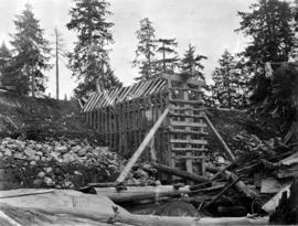
Burwell Lake, stream outlet from Burwell Lake before Dam was started
![Burwell Lake, view S[outh]. E[ast]. Along east shore of lake](/uploads/r/null/3/1/3151c8f33bc846f38da75ad100fc9be75a2c332d02c5769fd4431e74fb66bc89/0760f179-f6b4-43e4-915a-2947d9e55355-CVA275-29_142.jpg)
Burwell Lake, view S[outh]. E[ast]. Along east shore of lake
![Burwell Lake, view N[orth. W[est]. [north east?] along Dam face showing lake at its original wate...](/uploads/r/null/5/1/512924ce9846db6e812b5cd4146af1b202a8bf36b1f63f48d1666f0f3d6255b8/c56c1672-36d7-465d-afb4-dcc7bd262245-CVA275-28_142.jpg)
Burwell Lake, view N[orth. W[est]. [north east?] along Dam face showing lake at its original water level and newly completed repairs
Burwell Lake, view of Dam face after completion of repairs
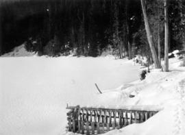
Burwell Lake, view of lake north side from Spillway

Burwell Lake, view of Crib Dam looking north
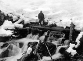
Burwell Lake, view of Spillway Dam showing leaks
![[Logging, clearing in the Watershed district]](/uploads/r/null/8/6/8640647f4ed3ed89b7b5b98661382289a848830db9f61bae861b6781520bb7b9/614c9573-5445-44b9-956d-4388aebfcbd0-CVA275-23_142.jpg)
[Logging, clearing in the Watershed district]
![[Logging railway line through Watershed district]](/uploads/r/null/4/5/45eb3a42dead444dbef6ddc679ad042f8de7b61408cff56b0db8983ce78e5dbb/5983572e-5753-4709-9242-9737dd6c6037-CVA275-22_142.jpg)
[Logging railway line through Watershed district]
![[Logging railway line through Watershed district]](/uploads/r/null/5/b/5b102ce6f5fa1892b55b946c6c497be2880fc9e76764354508f0b99ee60fd333/4948c845-8729-4234-a046-dc9a427274b1-CVA275-21_142.jpg)
[Logging railway line through Watershed district]