![[Mrs. Benjamin Springer (nee Frances Nias)]](/uploads/r/null/c/a/ca224d65615780f4d8db5b187e45a1ca4c1fe491e81acf2c4b841e6883315c99/7464c91c-c001-4588-bfc5-f425b0f080dc-A34654_142.jpg)
[Mrs. Benjamin Springer (nee Frances Nias)]
- AM54-S4-: Port P451
- Item
- [ca. 1860] ; reproduced 1940
Part of Major Matthews collection
Head and shoulders portrait
1848 results with digital objects Show results with digital objects
[Mrs. Benjamin Springer (nee Frances Nias)]
Part of Major Matthews collection
Head and shoulders portrait
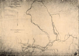
Sketch map of part of British Columbia showing trails and routes of communication
Part of Major Matthews collection
Item is a photostatic copy of a manuscript map showing trails and routes of communication in a portion of British Columbia from the Canada-U.S. border in the south to Seaton Lake in the north, and from the coast to Vermillion in the east. The section of coastline extends from Semiahmoo Bay in the south to Point Atkinson in the north. Map shows the location of mule trails and wagon roads, and includes a trail in progress from New Westminster to Burrard Inlet (North Road), trails from Whatcom to Hope and Semiahmoo to Derby, the Hudsons Bay Brigade Trail, Douglas Road, a trail proposed by Colonel Moody from New Westminster to Fort Hope, and the Dewdney Trail. Included with the map is a 1949 letter from Major Matthews, City Archivist, to J.M. Pearce in which Matthews describes the map, and a 1952 enquiry from L.B. [Housler] for a map showing the Dewdney Trail.
![[View of the Thompson River east of Lytton]](/uploads/r/null/b/5/b57bdc9554f4c089b187d1c5f5b233acbf931272e64dad2a0b54dd28040149cf/21978601-2e31-4d42-983f-3d601c619e55-A33843_142.jpg)
[View of the Thompson River east of Lytton]
Part of Major Matthews collection
![[A part of the Cariboo Road between Hell's Gate and Chapmans]](/uploads/r/null/0/9/09f564a5e10bf8b5b528d6cef608078781396fb613caaf73894b7adb3890e28a/20f81bdb-6c16-431f-a020-ec7dbd161749-A33841_142.jpg)
[A part of the Cariboo Road between Hell's Gate and Chapmans]
Part of Major Matthews collection
![[A part of the Cariboo Road]](/uploads/r/null/3/2/325b5ab94be7474ca99a4c6172efdaacbc096e5e7d14797a940ba9f1978735da/e943c3c1-170d-4b5c-a086-104eb24bb724-A33836_142.jpg)
Part of Major Matthews collection
![[A part of the Cariboo Road]](/uploads/r/null/0/4/0451742b8f917ab9edd6b6e459fc385a9414ee9989dcb46d1e7183d293552284/cd8f24b9-f274-4655-bd36-999be6a1c680-A33839_142.jpg)
Part of Major Matthews collection
![[Nicaragua Bluff on the Cariboo Road]](/uploads/r/null/2/1/212ee267c1018cf936840d29525145920f13592d01c4166f02011afb7960667e/dfe8ff21-00f5-46e8-af64-5e05462e6164-A33842_142.jpg)
[Nicaragua Bluff on the Cariboo Road]
Part of Major Matthews collection
![[Hill 19 on the Cariboo Road]](/uploads/r/null/a/7/a7b7a913e1e5325c312ae63d254ada4c643f0714061a8c4eae87d2593375f76d/c51b19f1-c3f8-4602-ab31-e440fec83226-A33838_142.jpg)
Part of Major Matthews collection
![[The Cariboo Road between Hell's Gate and Alexandra Bridge]](/uploads/r/null/c/a/ca92cca8713ae10c685a422d7a45a7ee840c766362394ef7ed5e775c28cc9de9/3335f8a1-c7b7-46ce-af78-7823f86b7b38-A33840_142.jpg)
[The Cariboo Road between Hell's Gate and Alexandra Bridge]
Part of Major Matthews collection
![[Cariboo road wooden bridge]](/uploads/r/null/6/8/68ce5215eae39e398be57511d2452aa8f265152be77a8b6ed651889e33f9a344/a7cf865a-d31b-4eda-b323-60e372cd7756-A24445_142.jpg)
Part of Major Matthews collection
![[Mr. and Mrs. John Linn]](/uploads/r/null/f/1/f15ad8f20d26462863e1210e99859525f317649976c206b03ee09ddfaf34e067/e4883cff-d744-4d1a-ad4b-551fe1f88127-A61472_142.jpg)
Part of Major Matthews collection
Studio portrait
![[Barnard's Express and Stage Line with Royal Mail enroute to Barkerville ]](/uploads/r/null/8/f/8f1cd724a7ea0cb0754fe91d3bd553d4b5dbb3ea1b41d2cd9a46ae333ab72ea9/81e20b25-119d-4c84-8ffd-3bca5d2d1723-A37625_142.jpg)
[Barnard's Express and Stage Line with Royal Mail enroute to Barkerville ]
Part of Major Matthews collection
![[Hudson Bay Company's S.S. "Beaver"]](/uploads/r/null/e/8/e8a53b2741fa5f8533d9eba315b0638435205092f440bb0f46821f9d9efc9afc/105dcd63-9309-4438-bcb9-cfcb8ea3c65a-A23968_142.jpg)
[Hudson Bay Company's S.S. "Beaver"]
Part of Major Matthews collection
![[Five unidentified First Nations men]](/uploads/r/null/5/3/537bfb63d8e160f2acbb382b154bea91df35c24244eee0d6a24dfd0babccb41c/4e0527b8-4b9e-4d2c-9cc5-f5f0e21fffd7-A22896_142.jpg)
[Five unidentified First Nations men]
Part of Major Matthews collection
The man on the far left is thought to be Alkali Lake Chief Quil - Quailse and the man on the far right is thought to be Williams Lake Chief William. The man in the centre is holding a Semour malacca staff with a cast silver head.
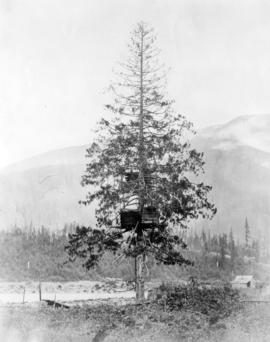
![Canoe Burial [in tree]](/uploads/r/null/1/b/1bdf9553ba481a9ab59e4d6fb0a0e818c422c700a3c909d293b789fc46d6baac/2fcc2d63-4341-40a6-867c-f9371b502e22-A26508_142.jpg)
Part of Major Matthews collection

Part of Major Matthews collection

Part of Major Matthews collection
Photograph shows longhouses

Part of Major Matthews collection
Photograph shows a mule and covered wagon train in the distance beside Jackass Mountain

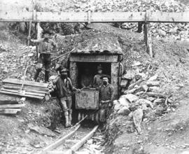
"Ne'er do well" claim, Cariboo
Part of Major Matthews collection
Photograph shows a trestle bridge in the background
![[Unidentified native man]](/uploads/r/null/3/0/30529146abb9c0aacb0c8485080139afb3b8694e1fa973062903a8d46637ffc9/4ce76977-2fa8-41ae-9b70-1ba34bd5613e-A26504_142.jpg)
Part of Major Matthews collection
Head and shoulders portrait
![[The Cariboo Road at Nineteen Mile]](/uploads/r/null/4/1/418b5bc66fd6c6308d93b02797fddf3bde764414fc361ca0b3480c9f1213aa23/a48be127-5cb2-454d-91a4-f5ac16d61091-A33950_142.jpg)
[The Cariboo Road at Nineteen Mile]
Part of Major Matthews collection
![Songish [Songhees] group V.I.](/uploads/r/null/5/a/5a6efcef723d7560efb8f2101502fecba70c19156e4f0e98341b0b7c63d7a0be/11a1a9ba-f49a-444d-98af-d5de5ec3dcef-A26502_142.jpg)
Part of Major Matthews collection

Part of Major Matthews collection

Part of Major Matthews collection
Head and shoulders portrait
![Indian Chief's Grave [in the Fraser Canyon, B.C. near Lytton B.C.]](/uploads/r/null/6/5/652f602db9758553ddbc4c37aca02c40aab2890ca4f3a3891d1e1ecb23a57187/6a2fd72f-73bb-4f43-8d50-6f0be0035dcb-A26510_142.jpg)
Indian Chief's Grave [in the Fraser Canyon, B.C. near Lytton B.C.]
Part of Major Matthews collection

Part of Major Matthews collection
Part of Major Matthews collection
Photograph shows fish storage sheds in a tree
Part of Major Matthews collection
Photograph shows men at the entrance
Part of Major Matthews collection

Part of Major Matthews collection
Photograph shows men, horses and gear waiting to cross a river on a wooden barge controlled by ropes and pulleys

Part of Major Matthews collection

Part of Major Matthews collection
Photograph shows elevated fish storage sheds
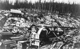
![Gold diggings [on] Leach River, B.C.](/uploads/r/null/b/2/b29a5a2036a5bb83a50855637173e96f3105c432c53f7491a5e10a36d2516566/cf36bdd2-cbcd-430e-9487-f3eef153e008-A33820_142.jpg)
Gold diggings [on] Leach River, B.C.
Part of Major Matthews collection

Part of Major Matthews collection
![[Phillip Sullivan]](/uploads/r/null/2/2/22125fe7e955b8ecc888c2caebc058031383e9c5d422af0de2f9e32d99970f1d/5fb35d4d-7cb1-4940-99b0-8f1b1eed6766-A35099_142.jpg)
Part of Major Matthews collection

The wagon road at the 17 mile post - road to Goldfields
Part of Major Matthews collection
Photograph shows a road on the side of a mountain
![[Hugh McRoberts]](/uploads/r/null/d/5/d5d4316e30c9561b0947b134e622471b824cfc0885afc898324eca1c1166e8f0/d1910833-a3be-47df-8490-506b55c50e9a-A61987_142.jpg)
Part of Major Matthews collection
Full-length portrait
![[Studio portrait of unidentified First Nations Woman in European-style clothing]](/uploads/r/null/c/f/cf11f0c4bfbbb5eac2feb54623e30aa4980c1e022474fce717a5a9fbd73933fd/2f2db698-95d1-49ea-9889-fe35db48bfcf-A22897_142.jpg)
[Studio portrait of unidentified First Nations Woman in European-style clothing]
Part of Major Matthews collection
![[Studio protrait of an unidentified First Nations man]](/uploads/r/null/c/f/cfa04a7d3ec559b6eaed021b24024838b3c10fa480c3d5fcf685c6284ef7b454/5f97521f-f439-4ef5-b94d-3c9f522be313-A22889_142.jpg)
[Studio protrait of an unidentified First Nations man]
Part of Major Matthews collection
![[Unidentifed First Nations man]](/uploads/r/null/c/2/c2a431c7c4c44e23ff5183d28e0e55c903a8155f203b90d455f5917f5a414b31/5c47770a-7ca0-45a6-be0e-51680e5e9e24-A22905_142.jpg)
[Unidentifed First Nations man]
Part of Major Matthews collection

Deadman's Island - Vancouver Island
Part of Major Matthews collection
![H.M. Ship "Chanticleer" [in Esquimalt harbour, Vancouver Island]](/uploads/r/null/4/7/477d57b381497480e2fc96b3ff9f2a5b880f1c0b9c659e5d876bafc40b05cef9/1d63151b-557e-4e32-9a47-7548d15ebcb3-A22854_142.jpg)
H.M. Ship "Chanticleer" [in Esquimalt harbour, Vancouver Island]
Part of Major Matthews collection
Photograph shows the ship at anchor with the sails open for drying.

Part of Major Matthews collection
![China Bluff on way to Boston Bar - Frazer [Fraser] River](/uploads/r/null/7/b/7bd123659bbb4dc0aa3970fe573df39cbf2f6b12f7e5747300a89968847289cf/51f452e5-0b09-4380-a408-9ad604c969d5-A22917_142.jpg)
China Bluff on way to Boston Bar - Frazer [Fraser] River
Part of Major Matthews collection
![Suspension Bridge - Frazer [Fraser] River](/uploads/r/null/f/d/fd8dc71b367897655629c415eb95fd5db096c3073e913c642d2318d041a2b6e5/e03316a1-8594-4826-b4c1-8663a9c77c25-A22915_142.jpg)
Suspension Bridge - Frazer [Fraser] River
Part of Major Matthews collection
![[Group portrait of three unidentified First Nations People]](/uploads/r/null/9/8/98b7d5f143bcc3b50e644b6c275f3519989d80a4565dcbb979e4b9d276a75b69/dfb85ca1-741e-4164-949d-45a2ad9a3c58-A22884_142.jpg)
[Group portrait of three unidentified First Nations People]
Part of Major Matthews collection
Photograph shows woven hat and basket.
![[Studio portrait of an unidentified First Nations man]](/uploads/r/null/2/b/2b2b97bc28f0ca3e7b3e5e8ce4663ec0824ed6b35c5c9e3253d512248f3c1a7b/e55ba3b7-b8fb-427d-b9ba-b55a3f8adf53-A22890_142.jpg)
[Studio portrait of an unidentified First Nations man]
Part of Major Matthews collection
Photograph shows woven hat.
![[Studio portrait of an unidentified First Nations man]](/uploads/r/null/b/4/b446336d6c4e01c95c6bbf3257e0448f00c250a86aed9b92eb79a0ceea48836c/0b859628-08e1-44fd-9140-5ac223dcccb4-A22891_142.jpg)
[Studio portrait of an unidentified First Nations man]
Part of Major Matthews collection
![[Studio portrait of Walter Hastings]](/uploads/r/null/1/e/1ee391d7719fc5dd060db83c3727b7037cef5bdab19790e9ef592252cb5a457f/5611c9e5-7377-44ab-900e-57fc43cbcd9a-A22760_142.jpg)
[Studio portrait of Walter Hastings]
Part of Major Matthews collection