![[Moody Avenue and Seventh Street]](/uploads/r/null/4/a/4a47ba26ff022cbedb4c458cdaae1313c7d362a053c46d9cee5234510d242e07/35244082-830d-4917-8d46-0e6df8091c1d-A09195_142.jpg)
[Moody Avenue and Seventh Street]
- AM54-S4-: Dist N83.2
- Item
- [ca. 1911]
Part of Major Matthews collection
Photograph shows street sign amongst tree stumps in partially cleared land.
17 results with digital objects Show results with digital objects
[Moody Avenue and Seventh Street]
Part of Major Matthews collection
Photograph shows street sign amongst tree stumps in partially cleared land.
![[Ferry line-up extends down Lonsdale Ave. from 8th St.]](/uploads/r/null/3/6/367ef713063c6e5458ccbd6abe9202e417d4a8156909c4fb1e3a7c2baada4cdc/daa5f6ad-1e38-4e0a-9038-59cfd6cd1edc-A24498_142.jpg)
[Ferry line-up extends down Lonsdale Ave. from 8th St.]
Part of Major Matthews collection
![[Ferry line-up on Lonsdale Avenue up to Eighth Street]](/uploads/r/null/0/7/07c1d194551657a593def712e867cd96259b6e82559677fc17d0b3c0ceceb28d/88726415-08cd-4424-9062-15ff90ff2cdf-A24499_142.jpg)
[Ferry line-up on Lonsdale Avenue up to Eighth Street]
Part of Major Matthews collection
![[Northern view of Lonsdale Avenue from the ferry dock]](/uploads/r/null/2/a/2a7bb34b044a9f06e963b6af0e946ceb80777fcb87e3c08a59497c37a76f46fd/b72e1250-2f39-4a4a-91ff-3088c0f00501-A26823_142.jpg)
[Northern view of Lonsdale Avenue from the ferry dock]
Part of Major Matthews collection
![[Northern view of Lonsdale Avenue]](/uploads/r/null/0/0/004f60b942e23702aaee6204aee266b4ad516e517df3f70971bf02819643b669/ae2e7cc4-bbec-4154-a6e4-c8fbf58beb95-A26824_142.jpg)
[Northern view of Lonsdale Avenue]
Part of Major Matthews collection

Ferry Wharf North Vancouver, B.C.
Part of Major Matthews collection
![[Fairmont Road washed out after the storm]](/uploads/r/null/f/d/fdac97656d097c1db744ea7ebff607ce140d236c2c466c08c6de0f6317783415/616b630a-7f25-40f6-9722-b0b838b2a7aa-A33735_142.jpg)
[Fairmont Road washed out after the storm]
Part of Major Matthews collection
![[Fifteenth Street looking east towards Grand Boulevard]](/uploads/r/null/7/3/73a89135f77f03c2170bc52234ba67e4d5b33dd68391be03e9ca3753fb8abd65/1332756e-55c4-4d2a-93f8-9e02d7c4bc28-A33961_142.jpg)
[Fifteenth Street looking east towards Grand Boulevard]
Part of Major Matthews collection
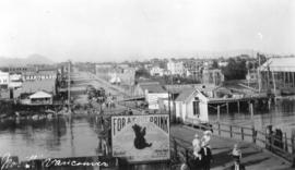
Part of Major Matthews collection
Photograph shows the ferry landing and Lonsdale Avenue
![[Looking north along Lonsdale Avenue from the ferry wharf]](/uploads/r/null/1/e/1ef12d281e91fc1c1a49a731cfc31bb1cf33747b5be716973e17e8f0372b7a3f/319fd277-2b1f-4626-994b-3063bae557af-A62579_142.jpg)
[Looking north along Lonsdale Avenue from the ferry wharf]
Part of Major Matthews collection

Part of Major Matthews collection
Dial map of the city of Vancouver including the adjacent municipalities
Part of City of Vancouver Archives technical and cartographic drawing collection
Item is a street map showing Vancouver, Burnaby, New Westminster, West Vancouver and North Vancouver on one side and the University Endowment Lands, Surrey, Maillardville, Lulu Island and Sea Island on the other.
Part of City of Vancouver Archives technical and cartographic drawing collection
Item is a street map showing Vancouver, Burnaby, New Westminster, West Vancouver, and North Vancouver on one side and the Lower Mainland from Vancouver to Chilliwack on the other. Item includes lists of businesses, schools, public buildings, hospitals, bathing beaches, fire halls, and golf and country clubs, as well as text advertising the products and services of the Dominion Map and Blueprint Company.

Canadian Traffic Signal Corporation - Photo of New Signals
Part of Stuart Thomson fonds
Photograph shows Marine Drive at Heywood Park
![[Foot of Lonsdale Avenue from ferry terminal]](/uploads/r/null/b/b/bb495757dd002adb23951152985e71388ce81c70ee373cf6557f1e8f7f203b16/b14d2b0d-a70b-4a21-b634-f75d1d883e1e-A02676_142.jpg)
[Foot of Lonsdale Avenue from ferry terminal]
Photograph shows Lonsdale Street, looking north, as well as pedestrians, carriages, and some buildings.

City and District of North Vancouver
Part of City of Vancouver Archives technical and cartographic drawing collection
Item is a map showing the city and district of North Vancouver. It shows paved roads, gravel roads, unopened roads and a graphical depiction of the population as of 1947. A small inset map shows the position of the city of North Vancouver and the district of North Vancouver in relation to Vancouver, Burrard Inlet and West Vancouver. Annotations appear to be in J.S. Matthews' hand, noting a portion of North Vancouver as "King's Lynn".

Part of City of Vancouver Archives technical and cartographic drawing collection
Map shows Vancouver from West Boulevard to Boundary Road and from Burrard Inlet to the Fraser River. A portion of North Vancouver is also shown. Streets, parks, schools and golf courses are identified. Map joins with MAP 575 to create a complete map of the City of Vancouver.
Dial map of the city of Vancouver including the adjacent municipalities
Item is a street map showing Vancouver, Burnaby, New Westminster, West Vancouver and North Vancouver on one side and the University Endowment Lands, Surrey, Maillardville, Lulu Island and Sea Island on the other.
Item is a street map showing Vancouver, Burnaby, New Westminster, West Vancouver, and North Vancouver on one side and Lulu Island and Sea Island, Delta, Surrey, Langley and Maillardville on the other.
![North Shore Marine Drive [and] Point Atkinson, Vancouver, B.C., Canada](/uploads/r/null/b/3/1/b31126992eefcb817ddcd71e986e554566c5a7384d9b78337c6b98c541189b86/86aad77d-e1bb-4799-b9d0-da385dffbff1-AM1052P-2170_142.jpg)
North Shore Marine Drive [and] Point Atkinson, Vancouver, B.C., Canada

Ferry landing and Lonsdale Ave., North Vancouver