
Wartime Housing cottages in North Vancouver
- COV-S397-: LEG1593.1-: CVA 163-5
- Part
- Jan. 13, 1942
Part of City of Vancouver fonds
1645 results with digital objects Show results with digital objects
Wartime Housing cottages in North Vancouver
Part of City of Vancouver fonds

Part of City of Vancouver fonds
![Capilano [Creek] looking upstream from north part of island](/uploads/r/null/a/8/a896dc9c2db3c65159f7e2771c98e330ea3c12b91907157c4698e756dbb1826c/b3e6f5a4-4ff6-456c-84bb-263e82325018-A16531_142.jpg)
Capilano [Creek] looking upstream from north part of island
Part of City of Vancouver fonds
![Capilano [Creek] West Channel looking upstream from lower end](/uploads/r/null/1/1/119d1142158a2f8850f1a5e9d3775af1d6018a3291f1f2d51ee974cad3d03416/ddc2b9d6-276b-4887-9393-165796e72cef-A16533_142.jpg)
Capilano [Creek] West Channel looking upstream from lower end
Part of City of Vancouver fonds

Part of City of Vancouver Archives sound recording and moving image collection
Film is a travelogue showcasing scenery, attractions and industry in the Vancouver area. Film contains general and aerial views of Vancouver, plus sequences of the harbour, Vancouver International Airport, Stanley Park, UBC, the Vancouver International Festival and the PNE. Industry is depicted through shots of a sawmill, a fish cannery, a foundry and a shipyard (where the vessel Yukon is launched). Water sports, golf and skiing at Grouse Mountain are shown, as well as Queen Elizabeth Park, Capilano Suspension Bridge, the Queen Elizabeth Theatre, Granville Street at night and a White Spot drive-in. Individuals involved with the production of the film include: Jim Richardson (script), David Bennett (director), A.J.H. Pullinger (cinematography), Norma Jackson (editing), Lloyd Stump (sound), Saba Bros. Limited (gowns), Marguerite Roozeboom (art direction), recorded by Telesound, Lew Perry (producer).
![Seens [scenes] of Van[couver], Capilano, Stanley Park](/uploads/r/null/1/3/b/13bc9013786c37378f12ed8a438df461807fab1a389b9e9c2896f171e1c9e03f/b640bf28-47ef-404b-9944-eeb4bd5eeda9-2012-033_142.jpg)
Seens [scenes] of Van[couver], Capilano, Stanley Park
Part of City of Vancouver Archives sound recording and moving image collection
Item is a film showing various scenes around Vancouver. The first half of this film documents a Gray Line Tours bus trip through Vancouver and second half contains scenes showing landmarks of Vancouver and surrounding areas. Film contains footage showing: Empress of Japan Figurehead in Stanley Park, U.B.C., Chinatown, Hotel Georgia, Lion's Gate Bridge, Court House, Capilano Suspension Bridge, Capilano Golf and Country Club, Prospect Point, Stanley Park, views of downtown and North Shore Mountains from Little Mountain, City Hall, sailboats in Burrard Inlet, and Swimmers at Kits Beach.
![Capilano [River, North] Vancouver](/uploads/r/null/b/7/8/b78f57de17b47bbf531dea7db195235106f1f013de317beed5b8eb10555fab17/2b4d30b1-c99e-4816-8445-60c44448e68c-CVA312-02_142.jpg)
Capilano [River, North] Vancouver
![[Children standing on bridge at] Capilano](/uploads/r/null/b/0/1/b014969ad29bb674ee65ec3b3ff108d57b69782402647cb0bb2cd10a92261979/1f44383a-8c97-4ad8-898d-ebb8998589fa-CVA312-12_142.jpg)
[Children standing on bridge at] Capilano
![[St. Paul's] Catholic Church, North Vancouver](/uploads/r/null/a/9/d/a9d5e679046c5ce5a937351cb63e47b4a8e08a01326e5465b62084fd9df6184d/ffcc2ca5-6132-41ba-aefc-3ac320460151-CVA312-24_142.jpg)
[St. Paul's] Catholic Church, North Vancouver


Capilano River and Suspension Bridge
Item includes directions and rates for Seymour Mountain Chairlift.
Seymour : existing traffic and services
The natural environment of the Maplewood Estuaries
Item outlines the effects of development and planning implications for the ecology of the region.

Tram going across the Capilano River at the dam site; Lions' in the distance

Item is a photograph showing Chief Joe Mathias shaking hands with a young child. Annotation on verso: "Donated by Mrs. F.M. Bland, 1964."

Chief Mathias of Capilano with Grey Eagle
Item is a photograph showing Chief Joe Mathias of Capilano with Grey Eagle and three others. Annotation on verso: "Donated by Mrs. F.M. Bland, 1964."

Item is a photograph of the wishing well at the suspension bridge in Capilano Canyon. The well is flanked with unpainted statues, a male, a female, and three children. The well is decorated with first nations style art and the sign reads "The Old Indian Wishing Well of Capilano".
![Group on barge [(Transfer No. 2)including Carl and the Captain]](/uploads/r/null/9/7/9735730d81fed89a00747f3c1a819f5b3035ab3becbcaa10119d63504cb40135/b5445b2f-c4a2-4f8e-82bb-2142e654938d-A43632_142.jpg)
Group on barge [(Transfer No. 2)including Carl and the Captain]
Group portrait

CAA-AAA-Approved Ranch Motel : Marine Drive and Capilano Road, North Vancouver, B.C.
Item is a postcard showing the Ranch Motel in North Vancouver. Caption on back of photograph: "On the beautiful North Shore. Centre to all scenic panoramas. 7 minutes to city centre over Lions Gate Bridge. 48 modern units (some kitchens) heated pool, coffee shop. The back of the postcard includes personal correspondence addressed to Mr. and Mrs. A. Mortander.
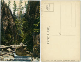
Cypress Canyon, North Vancouver, B.C.

Capilano Canyon and flume, Vancouver, B.C.

Target practice in the woods off Indian River Road, North Vancouver; Greenwood Archers

Suspension Bridge, Capilano Canyon, 200 feet high : Vancouver, B.C.

Bridge crossing Capilano Canyon, North Vancouver, B.C.
This postcard includes personal correspondence. Sent to Mrs. Harrison of Montreal, Quebec.

North Vancouver, B.C. - City Hall
This postcard includes personal correspondence. Sent to Miss G. Barnes of Mount Pleasant, Vancouver, B.C.
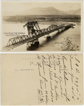
Second Narrows Bridge, Vancouver, B.C. Opened November 7th, 1925

Second Narrows Bridge, Vancouver, British Columbia
Item is a postcard printed with an image of the Second Narrows Bridge over Burrard Inlet. The vantage point is to the southeast of the bridge. The bridge is pictured in the process of opening.

Suspension bridge, Lynn Canyon, Vancouver, B.C.
Item is a folder containing a set of photographs printed with images of sites in Capilano Canyon, including the suspension bridge.

Suspension Bridge from Look-Out Point, Capilano Canyon, Vancouver, B.C. Canada
Item is a postcard

Suspension Bridge, Capilano Canyon, Vancouver, B.C. Canada
Item is a postcard

Capilano Canyon and flume, Vancouver, B.C.
This postcard includes personal correspondence. Sent to Mr. A. Brown, care of M.W. Brown, Volta, California.

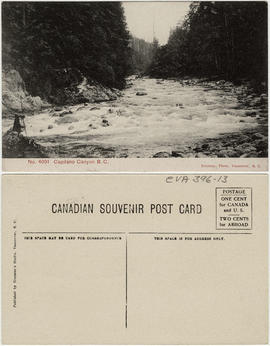
Capilano Canyon, near Vancouver B.C.

Capilano Canyon, Vancouver, B.C. (Canada)


Capilano Suspension Bridge, Capilano Canyon, B.C.

Capilano Suspension Bridge, length 450 ft., height 230 ft. Vancouver, B.C., Canada

Capilano Valley & the Lions, North Vancouver, B.C.

Capilano Valley and the "Lions," Vancouver, B.C.

First Capilano Canyon Suspension Bridge, height 200 ft., length 450 ft., Vancouver, B.C. Canada.

Fishing on the Capilano River, near Vancouver, B.C.

Map of portion New Westminster District
Part of City of Vancouver Archives technical and cartographic drawing collection
Item is a heavily-amended copy of a map illustrating intended land settlement and subdivision in 1877 in the future sites of Vancouver, Burnaby and the North Shore, from an area bordering on English Bay to an area bordering on North Arm. Also shown are bodies of water, Hastings & Granville Road, and the settlements of Hastings and Granville. Annotations by J.S. Matthews in 1954 made on the copy are tracings in white pen and darkening the background to improve the copy.
Part of City of Vancouver Archives technical and cartographic drawing collection
Item is a street map showing Vancouver, Burnaby, New Westminster, West Vancouver, and North Vancouver on one side and the Lower Mainland from Vancouver to Chilliwack on the other. Item includes lists of businesses, schools, public buildings, hospitals, bathing beaches, fire halls, and golf and country clubs, as well as text advertising the products and services of the Dominion Map and Blueprint Company.
![Plate 163 [Key Plan of North Vancouver]](/uploads/r/null/e/1/d/e1d59c4aba0a20f0522dd57d1ecfbcc6fa0e15d2cb581616d819932b7b4485b7/be98b40c-82d0-4d47-97d2-e5bc54e3e904-1974-100_142.jpg)
Plate 163 [Key Plan of North Vancouver]
Part of City of Vancouver Archives technical and cartographic drawing collection
![Plate 164 [Lonsdale Avenue to Second Street to Chesterfield Avenue to Burrard Inlet]](/uploads/r/null/b/c/5/bc5801cb1cab9f718c08d5e85247acf3c6c6d41621bd633be9636327b722a9cd/db55d2fa-bc36-4407-a98b-9c062774aa12-1974-100_142.jpg)
Plate 164 [Lonsdale Avenue to Second Street to Chesterfield Avenue to Burrard Inlet]
Part of City of Vancouver Archives technical and cartographic drawing collection
![[Clearing the road after the Seymour Creek washout]](/uploads/r/null/f/c/fc6cfe672265e867d583e925ffa6c0fd3a92c7305bcba121a6f71a099afd83a8/56561df4-6b84-4fc0-b5c1-6523edbfeb84-A33580_142.jpg)
[Clearing the road after the Seymour Creek washout]
Part of Major Matthews collection