It might have been Albert City, 1858, New Georgia 1792 : it was Granville, 1870, British Columbia, 1871 : it is Vancouver, 1886, British Columbia, 1871 : it is Vancouver, 1886, Canada, 1867
Second Narrows crossing
City of North Vancouver zone map showing "use" and "set-back" restrictions
Port of the City of Vancouver. Isometric view from the south-west
Dial map of Greater Vancouver and suburbs
City and District of North Vancouver
Map of West Vancouver and North Vancouver, street index, real estate information, and list of golf courses
Map of portion New Westminster District
Vancouver North. British Columbia
Plan of the townsite of North Vancouver
Index plan of provincial government lands to be sold at auction at Vancouver B.C. November 20, 1906
Sectional map and street directory of Vancouver : Dial map of the city of Vancouver including adjacent municipalities
Plan of provincial government property being a sub-division of a portion of expired timber lease situated in North Vancouver, New Westminster district, B.C., to be sold by public auction
Plan of town of Lonsdale : situate [sic] on harbour opposite City of Vancouver
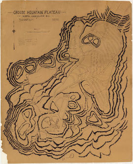
Grouse Mountain Plateau, North Vancouver, B.C.
Proposed route of Grouse Mountain Highway
Plan of district lots 264, 265, 266 and 552, North Vancouver, British Columbia
Plate 163 [Key Plan of North Vancouver]
Plate 164 [Lonsdale Avenue to Second Street to Chesterfield Avenue to Burrard Inlet]
Plate 165 [St. Georges Road to Second Street to Lonsdale Avenue to Burrard Inlet]
Map of West Vancouver and vicinity
Dial map of Greater Vancouver and suburbs
Dial map of Greater Vancouver and suburbs
Street index (Gibson Street to William Street) and tram stations
Street index (Royal Oak Avenue, Vancouver to Frederick Road, North Vancouver)


![Municipality of North Vancouver [Burrard Inlet]](/uploads/r/null/6/d/6d0d9a4b75b38672c56aa89a5984fe2d0e6d66be85f6f375cbe8e2fd7ac94a98/577914e1-3de2-478b-a629-5f391731387a-MAP588_142.jpg)

![Plan of town of Lonsdale : situate [sic] on harbour opposite City of Vancouver](/uploads/r/null/c/5/d/c5d4b56db1d7f9e1cf57dd5a974f6fcb23507e64543bad1bdd8f62139042389f/1cc57eaf-6c92-438e-a65d-335940738df7-MAP686_142.jpg)


![Plate 163 [Key Plan of North Vancouver]](/uploads/r/null/e/1/d/e1d59c4aba0a20f0522dd57d1ecfbcc6fa0e15d2cb581616d819932b7b4485b7/be98b40c-82d0-4d47-97d2-e5bc54e3e904-1974-100_142.jpg)
![Plate 164 [Lonsdale Avenue to Second Street to Chesterfield Avenue to Burrard Inlet]](/uploads/r/null/b/c/5/bc5801cb1cab9f718c08d5e85247acf3c6c6d41621bd633be9636327b722a9cd/db55d2fa-bc36-4407-a98b-9c062774aa12-1974-100_142.jpg)
![Plate 165 [St. Georges Road to Second Street to Lonsdale Avenue to Burrard Inlet]](/uploads/r/null/7/4/b/74bf056c6f380a72cc2df80556ee1fab18f65d4b16d8d010c950578becb6ee53/d1a63bcb-2baa-4bed-9444-00a74944242c-1974-100_142.jpg)


