![Plate 163 [Key Plan of North Vancouver]](/uploads/r/null/e/1/d/e1d59c4aba0a20f0522dd57d1ecfbcc6fa0e15d2cb581616d819932b7b4485b7/be98b40c-82d0-4d47-97d2-e5bc54e3e904-1974-100_142.jpg)
Plate 163 [Key Plan of North Vancouver]
- AM1594-MAP 625-: 1974-100.67
- Item
- Sept. 1905
Part of City of Vancouver Archives technical and cartographic drawing collection
27 results with digital objects Show results with digital objects
Plate 163 [Key Plan of North Vancouver]
Part of City of Vancouver Archives technical and cartographic drawing collection
![Plate 164 [Lonsdale Avenue to Second Street to Chesterfield Avenue to Burrard Inlet]](/uploads/r/null/b/c/5/bc5801cb1cab9f718c08d5e85247acf3c6c6d41621bd633be9636327b722a9cd/db55d2fa-bc36-4407-a98b-9c062774aa12-1974-100_142.jpg)
Plate 164 [Lonsdale Avenue to Second Street to Chesterfield Avenue to Burrard Inlet]
Part of City of Vancouver Archives technical and cartographic drawing collection
![Plate 165 [St. Georges Road to Second Street to Lonsdale Avenue to Burrard Inlet]](/uploads/r/null/7/4/b/74bf056c6f380a72cc2df80556ee1fab18f65d4b16d8d010c950578becb6ee53/d1a63bcb-2baa-4bed-9444-00a74944242c-1974-100_142.jpg)
Plate 165 [St. Georges Road to Second Street to Lonsdale Avenue to Burrard Inlet]
Part of City of Vancouver Archives technical and cartographic drawing collection

Street index (Royal Oak Avenue, Vancouver to Frederick Road, North Vancouver)
Part of City of Vancouver Archives technical and cartographic drawing collection
Part contains two pages from the booklet accompanying a guide map of Greater Vancouver. Pages include the last portion of the Vancouver and Burnaby street index, the New Westminster street index, and the North Vancouver street index from 1st Street to Frederick Road.

Street index (Gibson Street to William Street) and tram stations
Part of City of Vancouver Archives technical and cartographic drawing collection
Part is a page from the booklet accompanying a guide map of Greater Vancouver, and contains the last portion of the North Vancouver street index, the West Vancouver street index, and a list of Vancouver tram stations.

Dial map of Greater Vancouver and suburbs
Part of City of Vancouver Archives technical and cartographic drawing collection
Part contains a street map of Vancouver, Burnaby, New Westminster, West Vancouver, and North Vancouver showing railways, hospitals, parks and block numbers. The map includes two dials (numbered circles, paper indicators, a grid of block numbers and a street index used to find locations).

Dial map of Greater Vancouver and suburbs
Part of City of Vancouver Archives technical and cartographic drawing collection
Part contains a street map of Vancouver, Burnaby, New Westminster, West Vancouver and North Vancouver showing block numbers, street car, bus, and railway lines, parks and hospitals. Map includes two dials (a numbered circle, a paper indicator, a grid of block numbers and a street index used to find locations). A small inset map shows the Capitol Hill/Scenic Park area of Burnaby in greater detail.

Part of City of Vancouver Archives technical and cartographic drawing collection
Part contains an illustrated map of West Vancouver and North Vancouver showing major streets, mountains, rivers and creeks, and recreational attractions; a street index to the Greater Vancouver map on the other side of the sheet; a list of golf courses; and real estate information including a description of professional realtors, an amortization table, and calculations showing amounts paid in rent over many years.

Map of West Vancouver and vicinity
Part of City of Vancouver Archives technical and cartographic drawing collection
Part contains a map of West Vancouver, North Vancouver, and the northern parts of Vancouver and Burnaby. Map shows district lot and block numbers, streets, and distances from City Hall.

City of North Vancouver zone map showing "use" and "set-back" restrictions
Part of City of Vancouver Archives technical and cartographic drawing collection
Item is a map showing zoning in the city of North Vancouver. Zones include residential (single-family residences only, semi-detached residences and apartment blocks, hotels, etc.) business (Local shopping and business and buildings of the warehouse class) and industrial districts.

Plan of district lots 264, 265, 266 and 552, North Vancouver, British Columbia
Part of City of Vancouver Archives technical and cartographic drawing collection
Item is a map showing lot numbers and lot boundaries in the area from Phillips Avenue to Bewicke Avenue and Twenty-third Street to Burrard Inlet. An index map shows the location of the primary map in relation to the rest of Greater Vancouver.

Map of portion New Westminster District
Part of City of Vancouver Archives technical and cartographic drawing collection
Item is a heavily-amended copy of a map illustrating intended land settlement and subdivision in 1877 in the future sites of Vancouver, Burnaby and the North Shore, from an area bordering on English Bay to an area bordering on North Arm. Also shown are bodies of water, Hastings & Granville Road, and the settlements of Hastings and Granville. Annotations by J.S. Matthews in 1954 made on the copy are tracings in white pen and darkening the background to improve the copy.

Part of City of Vancouver Archives technical and cartographic drawing collection
Item is a map compiled and drawn by J.S. Matthews, City Archivist showing historic place names of Vancouver and the North Shore and listing some historic Burnaby names. A note in the bottom left hand corner reads: "Memorada. The precise location of "Albert City" is unknown, Narveaz was first; 150 years passed before his name was given to a landmark. His vessel's name "Santa Saturnina" has never been applied to anything at all."

Proposed route of Grouse Mountain Highway
Part of City of Vancouver Archives technical and cartographic drawing collection
Item is a map which shows a proposed route of Grouse Mountain Highway, including parcels of land through which it would pass. Shading indicates land owned by Hawkins & Horie. Burrard Inlet, Capilano Creek, Mosquito Creek, Lynn Creek, and Seymour Creek are also depicted.
Hawkins & Horie, Engineers & Surveyors
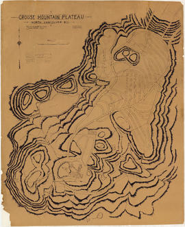
Grouse Mountain Plateau, North Vancouver, B.C.
Part of City of Vancouver Archives technical and cartographic drawing collection
Item is a topographic map showing the contours of Grouse Mountain Plateau, and various lakes, ponds, and creeks, and industrial developments including parking roads, parking areas, bridges, and scenic trails.

Index plan of provincial government lands to be sold at auction at Vancouver B.C. November 20, 1906
Part of City of Vancouver Archives technical and cartographic drawing collection
Item is a map showing lots owned by the provincial government to be sold at auction. Lots are located in North Vancouver, Vancouver, South Vancouver, Hastings Townsite and Burnaby.

Vancouver North. British Columbia
Part of City of Vancouver Archives technical and cartographic drawing collection
Item is a topographical map showing the eastern portion of Sechelt Peninsula, Keats Island, southern portion of Gambier Island, Bowen Island, West Vancouver, North Vancouver, and Vancouver. City streets and blocks are shown, as well as surveyed parcels of land. Map also shows depth contours in fathoms for Howe Sound and Burrard Inlet.
Let's go see! Inside Vancouver
Part of City of Vancouver Archives technical and cartographic drawing collection
Item is a tourist brochure featuring information on attractions on the North Shore (North Vancouver and West Vancouver) and maps showing routes to the area.
Map of West Vancouver and vicinity
Part of City of Vancouver Archives technical and cartographic drawing collection
Item is a map of West Vancouver, North Vancouver, and the northern parts of Vancouver and Burnaby, with an advertisement for R.P. Matheson Advertising Service and promotional images of West Vancouver on verso. Item appears to have been cut from a larger publication; some images on verso are cut off.
Guide map. Vancouver-New Westminster. Burnaby and North Shore municipalities
Part of City of Vancouver Archives technical and cartographic drawing collection
Item is a map which shows city streets, local areas, schools, hospitals, firehalls, parks and golf courses as well as railways, street railways and interurbans and bus routes. Street index included on verso. Item includes the original cover attached to the map.

Part of City of Vancouver Archives technical and cartographic drawing collection
Item is an illustrated map of Vancouver and the North Shore. Locations on the map are given in the original native languages. A legend provides translations of the location names. The map is illustrated with images of animals, trees and a large image of a totem pole.
Jessiman, Mary

Part of City of Vancouver Archives technical and cartographic drawing collection
Item is an architectural drawing of a Second Narrows crossing, bridging Vancouver and North Vancouver. The drawing consists of an elevation of the bridge, as well as a plan of the bridge and the north and south approaches.

Part of City of Vancouver Archives technical and cartographic drawing collection
Map shows Vancouver from West Boulevard to Boundary Road and from Burrard Inlet to the Fraser River. A portion of North Vancouver is also shown. Streets, parks, schools and golf courses are identified. Map joins with MAP 575 to create a complete map of the City of Vancouver.
![Municipality of North Vancouver [Burrard Inlet]](/uploads/r/null/6/d/6d0d9a4b75b38672c56aa89a5984fe2d0e6d66be85f6f375cbe8e2fd7ac94a98/577914e1-3de2-478b-a629-5f391731387a-MAP588_142.jpg)
Municipality of North Vancouver [Burrard Inlet]
Part of City of Vancouver Archives technical and cartographic drawing collection
Item is a copy of a map showing land subdivision for lands around Burrard Inlet, including North Vancouver and a portion of Vancouver. Major rivers and creeks are identified and the elevation of some mountains are given. The Canadian Pacific Railway from Port Moody to Vancouver is also shown.

Plan of the townsite of North Vancouver
Part of City of Vancouver Archives technical and cartographic drawing collection
item is a map showing lots and land subdivision in North Vancouver, most likely related to real estate sales. Index map shows the location of North Vancouver relative to Greater Vancouver.
![Plan of town of Lonsdale : situate [sic] on harbour opposite City of Vancouver](/uploads/r/null/c/5/d/c5d4b56db1d7f9e1cf57dd5a974f6fcb23507e64543bad1bdd8f62139042389f/1cc57eaf-6c92-438e-a65d-335940738df7-MAP686_142.jpg)
Plan of town of Lonsdale : situate [sic] on harbour opposite City of Vancouver
Part of City of Vancouver Archives technical and cartographic drawing collection
Map shows lot numbers and boundaries in the area from Keith Road in the north to Burrard Inlet in the south and from St. Patrick's road in the east to Chesterfield Avenue in the west. Several lots at St. Andrews Road and Fourth Street are hand-coloured pink, but the significance of the colouring is unknown. The ancillary map is an index map showing the location of Lonsdale in relation to Burrard Inlet and Vancouver.

Port of the City of Vancouver. Isometric view from the south-west
Part of City of Vancouver Archives technical and cartographic drawing collection
Item is a set of maps printed on one sheet. The main map shows an isometric view of the port of Vancouver from Stanley Park through the Second Narrows Bridge (including North Vancouver). The perspective point appears to be located above the Granviile Street and West Georgia Street intersection. Note that the isometric view of locations west of Granville Street is from the south-east, rather than the south-west, as indicated in the title.
The map depicts the port infrastructure, including piers, drydocks and companies located in the port.
The inset maps are a key plan showing the location of the port relative to the Lower Mainland as a whole, and a larger-scale map entitled "Plan of the Port of the City of Vancouver from Coal Harbour to Second Narrows". It contains more detail about the names of the various piers, drydocks and companies and shows the North Vancouver port facilities as well as south shore ones.
Indexed guide map of the City of Vancouver and suburbs
Part of City of Vancouver Archives technical and cartographic drawing collection
Item is a map showing district lots, blocks, and boundaries between the City of Vancouver, Point Grey, South Vancouver, Burnaby, New Westminster, and parts of Richmond, North Vancouver and West Vancouver. Concentric circles indicate the distance in miles from the intersection of Main Street and Hastings Street in intervals of 1/2 mile. Cover and street index attached.

City and District of North Vancouver
Part of City of Vancouver Archives technical and cartographic drawing collection
Item is a map showing the city and district of North Vancouver. It shows paved roads, gravel roads, unopened roads and a graphical depiction of the population as of 1947. A small inset map shows the position of the city of North Vancouver and the district of North Vancouver in relation to Vancouver, Burrard Inlet and West Vancouver. Annotations appear to be in J.S. Matthews' hand, noting a portion of North Vancouver as "King's Lynn".
Part of City of Vancouver Archives technical and cartographic drawing collection
Item is a street map showing Vancouver, Burnaby, New Westminster, West Vancouver, and North Vancouver on one side and the Lower Mainland from Vancouver to Chilliwack on the other. Item includes lists of businesses, schools, public buildings, hospitals, bathing beaches, fire halls, and golf and country clubs, as well as text advertising the products and services of the Dominion Map and Blueprint Company.
Dial map of the city of Vancouver including the adjacent municipalities
Part of City of Vancouver Archives technical and cartographic drawing collection
Item is a street map showing Vancouver, Burnaby, New Westminster, West Vancouver and North Vancouver on one side and the University Endowment Lands, Surrey, Maillardville, Lulu Island and Sea Island on the other.

Part of City of Vancouver Archives technical and cartographic drawing collection
Item is a map showing lot numbers, lot boundaries and property sold or reserved northwest of Capilano Creek along the north shore of Burrard Inlet. The map does not include street names.
Vancouver Harbour [sectional map]
Part of City of Vancouver Archives technical and cartographic drawing collection
File contains 42 maps showing soundings, harbour headlines, high water marks, shore lines, shoals, submarine cable, rail lines and trails in the Vancouver area. Maps also show names of businesses and other structures.