
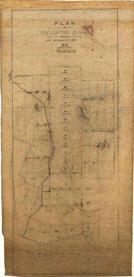
Map of portion New Westminster District
- AM54-S13-: MAP 1055.01
- Item
- 1877 (traced 1954)
Part of Major Matthews collection
Item is an annotated tracing of a map showing the future sites of Vancouver, Burnaby and the North Shore from an area bordering on English Bay to an area bordering on North Arm. Traced over by J.S. Matthews in 1954, it illustrates intended land settlement and subdivision in 1877. Also shown are bodies of water, Hastings & Granville Road, and the settlements of Hastings and Granville. Annotations are an introductory note by Matthews in August 1954 titled "Before Greater Vancouver." Enclosed with the map are four letters between J.S. Matthews and W.H. Hutchinson, Chief of the Geographic Division of the B.C. Survey and Mapping Branch of the Department of Lands and Forests, in 1954 concerning the map's provenance and Matthew's efforts to increase the legibility of copies of the original map.


![[The north shore of Burrard Inlet from Hastings Townsite]](/uploads/r/null/a/1/a12249ac806ceccb248b28fff01be751a527ddc606e220dbd0a3e6ff878549e0/2bc90306-b45b-4a89-953c-bffa74fff444-A26837_142.jpg)

![[Benjamin B. Springer and family on the front steps of their residence]](/uploads/r/null/e/6/e625d226aa88acc984b3fe4f44dc78c66c4ecae9ff111ec700942100aea458e3/7576dc7a-f3cf-41d2-a32e-7e948167eb95-A24555_142.jpg)
![[View of the first Capilano Creek dam under construction]](/uploads/r/null/b/e/bedbcf103b548bda85cf6901c9c4c1beea66a92ec3a205711b581ffc2f355de8/1005a023-9a5f-47be-8507-6cbe186c37a4-A25790_142.jpg)
![[Capilano Creek Dam]](/uploads/r/null/e/d/ed47628f64f1672f958233dce53864855e65ed095cbae462d201f7147d89a90e/52712de1-f51e-43b1-8d83-60ddd0d41b22-A25806_142.jpg)
![[Church picnic at Lynn Valley]](/uploads/r/null/6/2/62ee3ff5a6994267c237a85567561d631ce18b6fef2443f837864a570e7e60f5/880bbf34-787e-4e32-9f2d-270c6b50a8bc-A34530_142.jpg)
![[Church picnic at Lynn Valley]](/uploads/r/null/2/d/2d2d19fbc7b37535c9044695c6b0260924616a5a073178785471416f4f7b8598/c59c2faf-312d-4df0-b916-0458640c2674-A34531_142.jpg)

![[Capilano Creek Dam]](/uploads/r/null/0/2/026d540540368258e10e4aa5138eb417505fb9aaca394f01698547c979146bcb/9dd645c8-bda0-4552-bc03-ae804570eea2-A25805_142.jpg)
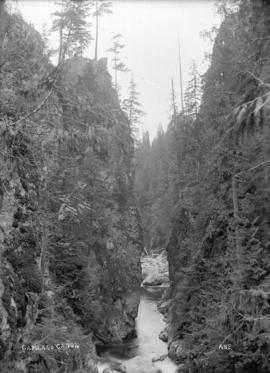
![[Capilano Creek above the dam]](/uploads/r/null/d/7/d78a64fd725077f4b81943466565401af03524f0b8b1efaac8bbcd903fcf1fce/7a1c0b76-114a-439f-ab58-c27baa72d1d5-A25807_142.jpg)
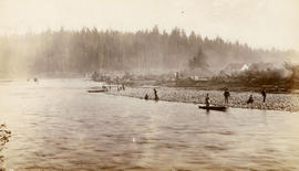
![[Man spearing salmon in Seymour Creek]](/uploads/r/null/8/7/87148857ce94646d1531f9ee8957aad670b22e3eb8951b4d71247bc0c327733a/31213c49-ad70-4a56-af4f-c2a107c5c701-A04199_142.jpg)

![[Capilano Creek Dam]](/uploads/r/null/a/c/ac4e509bc906b130ea5d0af6754302308993a1a1e9bfac8418dfe66e8a8a5d62/b8d53f43-f5f5-416a-bd34-239e28a01820-A25791_142.jpg)
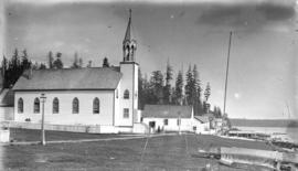
![[St. Paul's Church and assembley hall at the Mission]](/uploads/r/null/3/9/395d2541a8f28650061974a3809f402d930f558a81db53f7c762be9d8d0d0b5a/86fc38d8-4896-4b24-83a0-0994bb817a7b-A26408_142.jpg)
![[Capilano Creek waterworks]](/uploads/r/null/7/7/77575f1809735b16a9944f412163f98f596dd55ac925f50b13267002dfa3ffb8/232096c5-a1aa-4f89-8724-7825d09e71e0-A25800_142.jpg)

![[View of North Vancouver from across Burrard Inlet]](/uploads/r/null/f/3/f3f3752f66509bf91857f1790e0ef7e59de6f1125cf77326c5529552883a1768/d3c54dd1-21f8-4c66-9168-2d130918fd9b-A32575_142.jpg)
![[View of North Vancouver west of Lonsdale Avenue from the water]](/uploads/r/null/7/d/7db4eeb3905bc9bc756792b8ef613ac6133f37e630b22761bdc05a2b1be49457/50137feb-436b-4666-90e4-97db6afdd55b-A26821_142.jpg)
![[G.G. MacKay's cottage at Capilano Canyon]](/uploads/r/null/4/1/414e1dd4db5762e11976cccb0c1830d169518d3013a02440715258cd786b6244/d03b257f-178c-47ad-a3bb-1169c842ee08-A26820_142.jpg)
![[First dam on Capilano River]](/uploads/r/null/2/c/2c18611b7daf0e3d42499f11a298f2cf939cbb5a0fbc6271038b81e5c8af6a15/468a4292-241a-4b94-bb5d-e5a8aa363662-A25748_142.jpg)
![[View of North Vancouver from across Burrard Inlet]](/uploads/r/null/1/8/189ba35cb06084777fb2bda228ad93f3576931c505a2e6b41a11dcde757d3772/4ed44799-0b6d-4458-bc85-5202c7143989-A32577_142.jpg)
![[The caretaker's cottage and the Capilano Dam intake]](/uploads/r/null/e/9/e9fc9f6450a320f9d110d2c524376eb80c33973378eb284d56e36a543e405d42/2733b73e-c239-4ff4-b194-5446489bc706-A33532_142.jpg)
![[Prominent citizens of Vancouver at a picnic at Seymour Creek]](/uploads/r/null/5/0/503ce614d5f6ea36d22e78f5d6ef1c8d358466db2457c0b30bff2f6bdf89df67/4b2f5ba5-58a6-4575-be85-6262035fb104-A26754_142.jpg)
![[Capilano Creek Dam]](/uploads/r/null/5/3/539f32e9bde47f8b07c4ec5d803350024643ad7bb3ca55e3b3c5f7c873eedfc7/3acfb5f2-1c80-46a6-99f3-1f38293c8c8f-A25792_142.jpg)
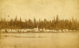
![[The Mission at North Vancouver Indian Reserve]](/uploads/r/null/e/b/eb486de914528fe53dcc963aa7db509aed7c69be8e8f1732617ca5533e637645/10e8d84a-dc34-46b1-b61d-d01c032c4b41-A26371_142.jpg)
![[View of North Vancouver from across Burrard Inlet]](/uploads/r/null/1/0/1000de853825031b1e00379ca07992e10f31302eb2d00e9a14c288b099176366/757aec20-76f0-451d-b3ae-b0d3e08ea726-A32576_142.jpg)
![[A group of campers in Lynn Valley]](/uploads/r/null/7/4/7440163e259864bc45fac25498cdcce1d8d257909442b11a79b3955bd1395657/e370ff71-9772-415a-a015-57bd9c2f094a-A61355_142.jpg)
![[Seymour Creek milk ranch owned by C.J.P. Phibbs and Fred Thompson]](/uploads/r/null/8/7/874f8dd79c89eb561d1d18ae42e7b61752cc7aa94a71fec16139ec5c4bfcfc0c/132417d5-0ace-478d-aa20-7eb8ea7969c8-A31806_142.jpg)
![North Vancouver from float [at] foot of Lonsdale Avenue](/uploads/r/null/4/b/4bd277a4acc375f4c76ebbc03764f9e519a72bc4dda0b25c133ce93f057032df/20929a6c-70bf-4dd4-966b-59bffc19f17d-A26830_142.jpg)
![[The men who completed the second ascent of Grouse Mountain]](/uploads/r/null/5/b/5b9ee5540d389a6c6619bd0df6e4f1240a5c33d4a5e81f59e34614b5ae340cd2/997bfb6e-6902-4b13-95e8-87b89003e58b-A32829_142.jpg)

![[George H. Dawson among tree stumps]](/uploads/r/null/d/a/da5d2a1efa2861be2a8ef467d3ea92476e6bf0f0f2e040f4f9e1ab5907c5f8aa/74771b77-0d88-4908-b9ed-5a7c0f94e7aa-A37660_142.jpg)
![[Land surveyors on a tree stump]](/uploads/r/null/5/4/543408b2198f7b8b28b2369f31e2088c0967cc71653e147f2fed569cd58ce11b/ba149aba-6963-4d03-84e2-640dd5cde325-A37657_142.jpg)
![[Land surveyors on a tree stump]](/uploads/r/null/d/1/d14c9b2e5d86553e83bc642d66d538dc78baeb093b341740ce6e1f89dee385d1/b6b930db-f963-4d2e-8168-1e9db02505f7-A37658_142.jpg)
![[George H. Dawson, Land Surveyor inside a huge stump]](/uploads/r/null/7/4/7417dac793da01740351ef91241d31fc50f3f289f08a7115ecba20fac233fead/b4bcc776-e9cb-4c1f-a708-d2b2149d749c-A37656_142.jpg)
![["The Capilano Tramps" in front of George Grant Mackay's cottage]](/uploads/r/null/0/4/04e66bb54dc69d047ee1bd749ed3779005ab9cf2a0bfa2b675ae30cbf1f08cdf/696639e5-0d8c-4854-a7e9-a0821aa95d3c-A33221_142.jpg)
![[Land surveyors among stumps]](/uploads/r/null/6/c/6c55e5eb76ffb24a076345362fa1aa3145d5081375f412d477ef0d11c70a5b69/095bf348-fc28-4d2c-a626-94e71cb0dfd0-A37661_142.jpg)
![[Land surveyors]](/uploads/r/null/a/c/acdd69224751cbf9bfb7857c1349152302f8d0d9aaee99204c9cb0296a26c0bf/6affe8ec-134c-4cb3-8dcb-a024f5dd32a4-A37659_142.jpg)
![[Men and women on Captain William Watts' gasoline launch "Ruth", at bank of Lynn Creek]](/uploads/r/null/d/1/d1811166ec6f27950147a8df48dcc80569a57dd02c40a965657e66bb521855d6/191fd630-944c-470a-9a58-988f97ea16f3-A07680_142.jpg)
![[First cottage built by A.E. Crickmay located between 15th and 17th Streets east of George Avenue]](/uploads/r/null/9/b/9b0c1de2122c5cd422563d56360f86ffccb8b2d80fda586024313f63b5d95f34/6440f394-4886-49b6-a7ea-fa3412da311f-A26741_142.jpg)
![[A group of men] on Grouse Mountain](/uploads/r/null/e/b/eb25c2de153b0fda640e8e8bab33d6e8984018de2f2170b71d4ec5fb3b5945d0/edf4eb67-c5eb-47c1-b20c-4d390890ed5f-A26670_142.jpg)