- AM336-S3-2-: CVA 677-850
- Item
- [191-?]; reproduced [196-?]
Photograph shows an elevated road and sidewalk running north under a flume. Photograph also shows houses and tree stumps.
61 results with digital objects Show results with digital objects
Photograph shows an elevated road and sidewalk running north under a flume. Photograph also shows houses and tree stumps.

Ancient and present valleys of the Lynn River
Photograph shows a sketch by Wm. Draycott of the Lynn Valley area.
![[Building and road construction on Londsdale Avenue]](/uploads/r/null/f/1/f10dfbb88cc2c6503ac75a3b3efd12dd7a01a0abd5f3efe7282f07fef7bb9aa8/4c1b332a-42d5-4fe3-b088-6e812894f803-A02533_142.jpg)
[Building and road construction on Londsdale Avenue]
A note on the back of the photograph mounting reads: "New building (west side) Lonsdale - 1st block from waterfront and ferry. View #3 - finished."
![[Building and road construction on Lonsdale Avenue]](/uploads/r/null/f/f/ff248f8e7872e502b15c01417e4bff66762f3216ed5705fbfc42af49c9cd3a38/6c8f438d-fca5-4854-9499-0a9abbaf3c59-A02534_142.jpg)
[Building and road construction on Lonsdale Avenue]
Photograph shows buildings on the west side of the street (with the nearest building unfinished), rocks spread along the road,and people on the sidewalk.


Capilano Canyon suspension bridge
Photograph shows three people on the bridge.

Photograph shows the car at a bend in the track, just before a crossing area.
![[Cliff and river], Capilano Canyon](/uploads/r/null/3/e/3e8447ddcb3c0c7a0232c20f6608f812fb77b7b15f6990c0ebad31889b21c276/ab17e8d9-a24a-4cfe-acc2-849b1fe0647b-A02692_142.jpg)
[Cliff and river], Capilano Canyon
![[Construction on] Lonsdale, first block from First Street (looking east)](/uploads/r/null/b/9/b9efd81fab3f0eeec5a149d52311d1aa24fb5e898bb85ba99080ee2e6ed62c8d/1669c797-6e10-4843-bfea-af49a5ff46d4-A02532_142.jpg)
[Construction on] Lonsdale, first block from First Street (looking east)
Photograph shows people on the street, as well as two men sitting on a cart full of planks next to a building construction site.

Corner Pipe Line and Fromme Road, Lynn Valley, B.C.
Photograph shows intersection of two roads, and surrounding trees and stumps. Photograph also shows a signpost indicating the corner of Fromme and Lynn Valley Roads.
![Covecliff, North Arm [Burrard Inlet]](/uploads/r/null/8/4/8463af0c36411888f04b7153cea6bec26b835a7588c5f145fffbe20211e348c1/2ed9fae3-0df8-4fca-8c85-686680ea24f0-A02280_142.jpg)
Covecliff, North Arm [Burrard Inlet]
Photograph shows boats and pier at shoreline of cove.

Demolition of trestle bridge spanning Hastings Creek on Lynn Valley Road
Photograph shows a partially demolished bridge, and a road extending north.

First house of worship, Shake Town (later called Lynn)
Photograph shows a sketch of a log cabin by W. MacKay L. Draycott.
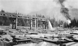
Flume emptying into water full of logs
Photograph shows a body of water full of split logs, a flume, and smoke in the distance.
![[Flume in] Capilano Canyon](/uploads/r/null/5/f/5f3c3872bdb5828c9499feca01de02805ed316cdbab961c8ea19bf3cbeb33104/b168e45e-8877-4774-88c4-aed792d21bd9-A02688_142.jpg)
Photograph shows a wooden flume on scaffolding running along the edge of the canyon.
![[Flume through Fromme property, crossing Draycott Road]](/uploads/r/null/0/e/0e253b0638272c39ff5d689b7beca3d05896833b737b9fd477d7cf513e267b86/da54d73a-6f20-4a33-a460-5d98a8f83aa2-A02704_142.jpg)
[Flume through Fromme property, crossing Draycott Road]
Notes on the back of the photograph read: "Looking north east. The flume is seen crossing the J. M. Fromme property and bisecting Draycott Rd. It continues to the right over Ross Road flume toward Moodyville. This area is now built up, so the vista has changed.
![[Foot of Lonsdale Avenue from ferry terminal]](/uploads/r/null/b/b/bb495757dd002adb23951152985e71388ce81c70ee373cf6557f1e8f7f203b16/b14d2b0d-a70b-4a21-b634-f75d1d883e1e-A02676_142.jpg)
[Foot of Lonsdale Avenue from ferry terminal]
Photograph shows Lonsdale Street, looking north, as well as pedestrians, carriages, and some buildings.
![[Group of men and women on suspension bridge], Capilano Canyon](/uploads/r/null/9/a/9a1e89654daa7b80953f8ae2ab7ddd98f1a77968dfada2de61f3a826619fbf58/7e30d99d-7fd6-4f70-8928-0607d68bb64d-A02685_142.jpg)
[Group of men and women on suspension bridge], Capilano Canyon
Photograph shows individuals on bridge, with river running underneath.
![[Group of men and women on] Suspension Bridge, Capilano Canyon, length 450 feet, height 200 feet,...](/uploads/r/null/4/e/4ec3b1c29e554dfa5f88260fab64164be76f5e9c4fee717d4253c93c4434844d/804f7ce3-a74d-4b4c-9970-4d352762570f-CVA677-892_142.jpg)
Photograph shows three men and five women posing on the bridge.
![[Group of men and women on the Capilano Suspension Bridge]](/uploads/r/null/b/9/b9c8628f8c3b141b4af15a20011738f6f3ae99a4058540bd78ba5ffd7367f074/7c6d9e7e-f6ca-48ae-b996-3503f972b932-A02737_142.jpg)
[Group of men and women on the Capilano Suspension Bridge]
Photograph shows two men and four women posing on the bridge.
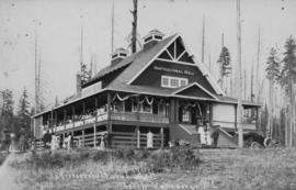
Horticultural Hall, North Vancouver, B.C.

![[Hotel Capilano, North Vancouver]](/uploads/r/null/3/0/303d70b7f466beb84a7a04cee879b51f61a0e32e9abb52b1f8659c543e92e5e1/f5d5f6bf-bf3a-49e1-a82c-212085edb56c-A02298_142.jpg)
[Hotel Capilano, North Vancouver]
Photograph shows hotel on top of small hill, stairs leading up to the hotel, and car parked at the bottom of the hill.

Ice age glacial deposits on east side of upper canyon of Capilano River
Photograph shows a cross section of an excavated area, showing layers of rock. Photograph also shows two men at the entrance to a shaft.

Intake bridge, Lynn Creek, B.C.
Photograph shows a small wooden bridge over a creek bed, connecting to a path in the forest.

Looking at east side of Capilano Upper Canyon - site of Cleveland Dam
Photograph shows buildings and cables at the edge of the canyon.

Looking at west side of Upper Capilano River
Photograph shows excavated site, with machinery and cables.

Looking east. Upper canyon on Capilano River. Buildings are contractors for Cleveland Dam
Photograph shows buildings and cables at the edge of the canyon.

Photograph shows river running down the canyon.
![[Man standing on rock ledge next to tall tree], Capilano Canyon](/uploads/r/null/1/f/1fb2b360cee1d1ea2a41a6d188821efb4316915637a44bb1025d4e937b92023c/9e4be03b-af62-405d-b7ff-d9bb49db7eca-A02691_142.jpg)
[Man standing on rock ledge next to tall tree], Capilano Canyon
![[Men and women on rock at Capilano Canyon]](/uploads/r/null/f/6/f6d7a4c59fac76597cdb2b4dff76a1c70aa7968ca1a237cfa4ddb1fe3ff96008/badfd9fe-e17c-46b9-ace8-4e6f577539d6-A02738_142.jpg)
[Men and women on rock at Capilano Canyon]
Photograph shows three men and four women posing on a rock above the Capilano River. Photograph also shows sides of the canyon and a flume running along one side of the canyon.
![Mending his ways, Lynn Valley, B.C. [man with steamroller]](/uploads/r/null/f/e/fe567ef453462d6cb33bd193f395aaf7364b6a7e7f7c52ff6812144ab70aa37f/a44e49df-a424-4e6a-8f34-563df8b148ed-A02694_142.jpg)
Mending his ways, Lynn Valley, B.C. [man with steamroller]
Photograph shows a man operating a steam roller on an unfinished road next to railway tracks.
![[North Vancouver ferry terminal at the foot of Lonsdale Avenue]](/uploads/r/null/9/9/99caa4c05e7e68cc51d2a9b44de8603b2b1e41ccdf47cb63224c4b6068d30f52/ec88d96e-a8ad-4d3b-b018-5fb518ae2e59-A02531_142.jpg)
[North Vancouver ferry terminal at the foot of Lonsdale Avenue]
Photograph shows people walking onto ferry terminal, with Lonsdale Avenue and buildings in the distance. Photograph also shows advertising billboards for products, including Black Bear Brand aerated water.
![[North Vancouver from Burrard Inlet]](/uploads/r/null/f/2/f285dd5633144f255b287145d9cec78b096827c3110720acace67fe73e7d654a/b97f757f-39e2-4c8f-9352-a095c360e4fe-A02535_142.jpg)
[North Vancouver from Burrard Inlet]
Photograph shows roads, houses, and other buildings near the North Vancouver waterfront.

North Vancouver's first streetcar
Photograph shows B.C. Electric Railway Company car, with conductor Dick Fawcett and motorman Walter King standing at the entrance.

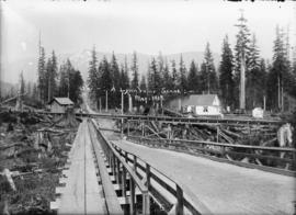
On the pipeline in 1909. Lynn Valley, B.C.
Photograph shows road, parallel plank sidewalk, and trees.

Photograph shows shoreline area, boats, waterfront houses, and mountains in the background.

Opening of the Seymour Creek Bridge by Premier McBride
Photograph shows a group of men and women assembled in front of the bridge.


Pete Lensois Hotel, North Vancouver
Photograph shows hotel buildings, beach change rooms, and bathers on shore.

Pipe line road, Lynn Creek, B.C.
Photograph shows muddy dirt road extending to mountain, a shack, and an elevated plank sidewalk next to the road.
![[Plank road and flume] between Sugdens and George Streets, Lynn Valley](/uploads/r/null/d/f/df03f489a5119820bf2f7e50e409932a1c4ac87aa7207a37ea12f291989561eb/698eb6d2-5a3b-4449-bdd9-6dda4b06b81a-A02705_142.jpg)
[Plank road and flume] between Sugdens and George Streets, Lynn Valley
Photograph shows road, flume, and tree stumps.
![[River flowing through] Capilano Canyon](/uploads/r/null/d/2/d22634e5ad6a7a525c5db6a82f99a3774a5b318acfa734dac5faef64c5b3f4d1/8da1abbf-a9f5-4548-9264-b3000cd1707b-A02689_142.jpg)
[River flowing through] Capilano Canyon
![[Road, sidewalk, and building construction in North Vancouver]](/uploads/r/null/f/f/fffdfb1f7188f50ad228b5298e641a92995f7478c55d66f1e059ac49221c7bd8/43dd48e4-0efb-41da-9f72-b05851c3663f-A02677_142.jpg)
[Road, sidewalk, and building construction in North Vancouver]
Photograph shows men working on an unfinished building and road. Photograph also shows two completed buildings, housing Walden Brothers Hardware, and M. A. Russell Groceries.
![[Rocky area of river in] Capilano Canyon](/uploads/r/null/4/5/454a428a7fb59347bccc22d6f817c6ceb756d0cc42d7600919cfecef67f74aa4/e58e2f36-3b2e-4e4f-bed4-e933d0b15852-A02690_142.jpg)
[Rocky area of river in] Capilano Canyon

Roslyn, North Arm (Burrard Inlet)
Photograph shows shoreline area.

Second Narrows bridge, Vancouver, B.C. Opened November 7th, 1925

Skating on Rice Lake, North Vancouver, B.C.
Photograph shows men and boys on frozen lake, with trees and mountain in the background.

Some trees omitted to show ancient and present valleys of the Lynn River
Notes on the back of the photograph read: "Revised copy of sketch of Lynn river canyons to show the correct placement of Phyllis Road (bottom of sketch); also more trees have been added."
![St. Andrew's Presbyterian Church, Sixth Street and Keith Road [North Vancouver]](/uploads/r/null/0/e/0e761332a5103fa062e695d1eb664edc75822052d6af9f7ddeb46f6bd2d1a339/b54e9546-e501-4e46-81fb-f8a6e234b218-A02245_142.jpg)
St. Andrew's Presbyterian Church, Sixth Street and Keith Road [North Vancouver]
Photograph shows the exterior of church building, with logs, tree stumps, and other debris surrounding the site. Photograph also shows a boy on the front steps of the church.