![[The wedding party of John Lawson's daughter outside Navvy Jack's house]](/uploads/r/null/8/2/82c0b2c341033e2b72f7d96d8a773c07b0e3eb8396736a85ee23d0dd969cfa00/d15396d8-bd47-4d09-a238-6b950dd67e20-A26822_142.jpg)
[The wedding party of John Lawson's daughter outside Navvy Jack's house]
- AM54-S4-: Out P80
- Item
- 1910
Part of Major Matthews collection
147 results with digital objects Show results with digital objects
[The wedding party of John Lawson's daughter outside Navvy Jack's house]
Part of Major Matthews collection
Part of Major Matthews collection
Album includes portraits of the following Reeves of West Vancouver: Charles Nelson, John Lawson, George Hay, Valient Vivian Vinson, David Morgan, R.C. Proctor, Sydney Gisby, Joseph Bentley Leyland, J. Edward Sears, Patrick Willoughby Field, William Dickinson, Thomas J. Brown, J. Howard Fletcher, A Hugo Ray, J. Richardson, and R.J.G. Richards. The album also includes some biographical information on the Reeves.
Nomenclature. Indian villages and landmarks, Burrard Inlet and English Bay, before the whiteman came
Part of Major Matthews collection
Item is a map which shows the geographic area bounded by the north shore of Burrard Inlet, the Fraser River, Point Atkinson, and the Burrard Inlet Second Narrows. Physical features on the map (primarily coastal sites) are labeled using both First Nations and European place names.
Matthews, James Skitt, Major
![[Great Northern Cannery, West Vancouver]](/uploads/r/null/9/0/90f8d1f7d801a768a392a47d0367fd6b963ada1e8f0174d40dd235af797a95db/81acecd3-098a-4747-b6af-830576750bbb-A04597_142.jpg)
[Great Northern Cannery, West Vancouver]
Part of Major Matthews collection
J.S. Matthews' notes with print or negative in Archives.
![[View of West Vancouver from Prospect Point]](/uploads/r/null/0/5/051c963366583e6b30846e1a25d81e8b8df434dbc69baf68d92b559ea38b5a40/1832ce63-26ab-4b5e-86c2-95c22cdfccf5-A04482_142.jpg)
[View of West Vancouver from Prospect Point]
Part of Major Matthews collection
J.S. Matthews' notes with print or negative in Archives.

B.C. Electric Head Office Staff Picnic Seaside Park Aug. 11-23
Part of Major Matthews collection
Group portrait
![[Mr. and Mrs. Fred Rogers and their daughter Mina camping at Point Atkinson]](/uploads/r/null/1/0/107a12383288d11c1809d4c47b62a829b510a616c149f6c66df931677b858758/cea37e6a-ed39-4dc9-a566-c9e6ceeed5ff-A62063_142.jpg)
[Mr. and Mrs. Fred Rogers and their daughter Mina camping at Point Atkinson]
Part of Major Matthews collection
![[Mrs. Henry Roome McDonald]](/uploads/r/null/d/7/d7cfd1a6796a1628f7b781aa49df76830fa8ca73799e7fda12c9c572fcfb2d3c/89dd4fd0-2945-40c7-a217-904a4f41d48d-A61944_142.jpg)
Part of Major Matthews collection
Studio portrait

The Canadian Fairbanks-Morse Company's Picnic, Seaside Park
Part of Major Matthews collection
Group portrait showing Lavina Freeman, Sarah Peter, Mr. and Mrs. James Peter and others
![[Thomas David Grafton and Lawrence Grafton]](/uploads/r/null/d/4/d43db335795a8adaf37063accd5be9d5de7899ae8a9519cb110d8d7470e85db5/969703b4-f9db-46df-9f41-dd2b39c5dac4-A61491_142.jpg)
[Thomas David Grafton and Lawrence Grafton]
Part of Major Matthews collection
![[View of Marine Drive looking west from 14th Street]](/uploads/r/null/1/d/1ddcd5b670835b959ef9e34ebed4515826f41620f919f648f91ab02ef24e52ec/98f75abf-36f0-4117-8ac3-91c5674158e8-A61057_142.jpg)
[View of Marine Drive looking west from 14th Street]
Part of Major Matthews collection
![[A stone bust of a man wearing a headdress]](/uploads/r/null/5/6/56718e052bd25613178e4d29a6e366182d7de71185d635b4d3a2888a13c19240/e3cbae86-3a9a-4f29-8ec4-99b55a44ccad-A59986_142.jpg)
[A stone bust of a man wearing a headdress]
Part of Major Matthews collection
Photograph shows a signature on the sculpture that may be 'Lindon E. Brown'

Part of Major Matthews collection
The item is a table of place names shown on map 56.01; Indian villages and landmarks, Burrard Inlet and English Bay, before the whiteman came. The table gives First Nations names and their approximate english meaning, or the European name given to the same location.

Map of portion New Westminster District
Part of Major Matthews collection
Item is an annotated tracing of a map showing the future sites of Vancouver, Burnaby and the North Shore from an area bordering on English Bay to an area bordering on North Arm. Traced over by J.S. Matthews in 1954, it illustrates intended land settlement and subdivision in 1877. Also shown are bodies of water, Hastings & Granville Road, and the settlements of Hastings and Granville. Annotations are an introductory note by Matthews in August 1954 titled "Before Greater Vancouver." Enclosed with the map are four letters between J.S. Matthews and W.H. Hutchinson, Chief of the Geographic Division of the B.C. Survey and Mapping Branch of the Department of Lands and Forests, in 1954 concerning the map's provenance and Matthew's efforts to increase the legibility of copies of the original map.

Part of Major Matthews collection

Part of Major Matthews collection
The map is a draft of MAP 56.01, "Indian villages and landmarks, Burrard Inlet and English Bay, before the whiteman came." It shows the geographic area bounded by the north shore of Burrard Inlet, the Freaser River, Point Atkinson, and the Burrard Inlet Second Narrows. Shown on the map are locations of First Nations and European settlements, streams, coastal features, and inland vegitation. Physical features are labeled using both First Nations and European place names.

Draft map of Indian villages and landmarks, Burrard Inlet and English Bay, before the whiteman came
Part of Major Matthews collection
The map is a draft of map 56.01, "Indian villages and landmarks, Burrard Inlet and English Bay, before the whiteman came." It shows the geographic area bounded by the north shore of Burrard Inlet, the Fraser River, Point Atkinson, and the Burrard Inlet Second Narrows. Shown on the map are coastal sites labeled with First Nations place names.

Part of Major Matthews collection
Part of Major Matthews collection

Part of Major Matthews collection
Photograph shows a steamboat travelling into the harbour and the Prospect Point signal station and lighthouse in the background
Part of Major Matthews collection
Item is a topographical map of the municipalities surrounding Howe Sound and Burrard Inlet. Municipal boundaries, roads and other transportation infrastructure, and radio stations are also included. The Greater Vancouver water supply areas and waterways are shown along with pipe lines, power lines and telegraph lines.
![[Looking east towards Prospect Point]](/uploads/r/null/3/5/353b1aa08c35d1d8b5089e30dbf1e7cbd7be47afb7288ca95f34e01df15f3530/0799ffa0-869e-459b-8fdc-d783d59aef7c-A49523_142.jpg)
[Looking east towards Prospect Point]
Part of Major Matthews collection
![[J. Edward Sears, Reeve of West Vancouver dedicating the Narvaez Cairn at Ambleside Park]](/uploads/r/null/d/e/de8f556d1f9aa158ba6a5368f952ab510a437d4252ffd834fcec614f027b909e/6ddbe921-d4ff-45e6-a668-9df48ebfc7ac-A32642_142.jpg)
[J. Edward Sears, Reeve of West Vancouver dedicating the Narvaez Cairn at Ambleside Park]
Part of Major Matthews collection
Photograph shows August Jack Khahtsahlano and others
![[A hydro pole knocked over from erosion caused by flooding]](/uploads/r/null/2/2/22769ea9898777b296d52a5aa01f40f294402bfffe3a540656e1c447612ee714/3eed74e6-29c6-48c4-9dd2-5851df064d19-A33729_142.jpg)
[A hydro pole knocked over from erosion caused by flooding]
Part of Major Matthews collection
![[Fisherman's Cove in Eagle Harbour]](/uploads/r/null/e/d/ed75d429d432902ab0a36d0d6a9c5c54c2af46d48fd76303adadfa20588cffe2/0d497ad1-6d05-412f-92a6-98d476dcb6c3-A33446_142.jpg)
[Fisherman's Cove in Eagle Harbour]
Part of Major Matthews collection


Part of Major Matthews collection

Part of Major Matthews collection
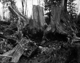
![North shore slash from old P.G.E. [Pacific Great Eastern Railway] tracks looking towards Marine D...](/uploads/r/null/0/e/0e1127a1f4fde05222abd49343b974a3a30ca7933cbfc6af292b4d4c1783f404/e0755bd9-8dcd-4371-9dcb-6d519cd598f2-A59658_142.jpg)
Part of Major Matthews collection

Part of Major Matthews collection

Part of Major Matthews collection

Part of Major Matthews collection
Photograph shows Brockton Point in the background
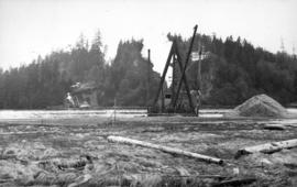
Dredge getting depth on North Shore for basin for anchorage scows carrying building material
Part of Major Matthews collection
Photograph shows the Prospect Point signal station

Part of Major Matthews collection

Part of Major Matthews collection

Part of Major Matthews collection
Part of Major Matthews collection
Part of Major Matthews collection

Part of Major Matthews collection
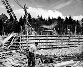
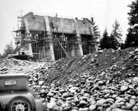
Concrete foundations of North Shore bridge-cable anchorage, sunk to a depth of thirty-five feet.
Part of Major Matthews collection

Part of Major Matthews collection
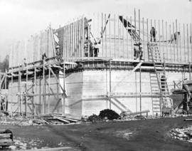
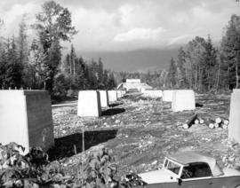
20,000 tons of solid concrete form this "anchor" to the steel suspension cables on North Shore
Part of Major Matthews collection

![[View of Howe Sound from the Whytecliff Hotel]](/uploads/r/null/b/b/bb0d9e67af7bce182cff0e27ba40bcf503dcf795d6093c8cf03285eda539fa67/7b8d3202-94de-4e8b-9815-480c52649b3e-A33253_142.jpg)
[View of Howe Sound from the Whytecliff Hotel]
Part of Major Matthews collection
Photograph shows Gambier Island, Hood Point and Bowen Island

1163 Keith Road, West Vancouver on July 18, 1965
Part of Major Matthews collection
Snapshot shows ground level view of 1163 Keith Road, West Vancouver on July 18, 1965.
![Bruce, Wendy & Ashley [Abbott] taken on the back veranda against the dining room windows](/uploads/r/null/f/e/febacfb85ed3884708d932388c656a5f12c517d9e30929dda8ecb0ef00681024/ae413225-6864-4e23-b24f-d3741e2f41fa-A71118_142.jpg)
Bruce, Wendy & Ashley [Abbott] taken on the back veranda against the dining room windows
Part of Major Matthews collection

Bruce's 1st birthday, Feb. 13, 1956
Part of Major Matthews collection
Snapshot shows Bruce Abbott "looking at his birthday card from his Grandma and Grandpa Matthews" at "Five Cedars" according to description on verso.

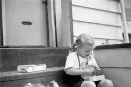
Ashley May's 4th birthday, June 11, 1953
Part of Major Matthews collection
Snapshot shows Ashley May Abbott opening her birthday present from her great-grandfather, Major Matthews.
Ashley May's 4th birthday, June 11, 1953
Part of Major Matthews collection
Snapshot shows Ashley May Abbott opening her birthday present from her great-grandfather, Major Matthews.

Ashley May's 4th birthday, June 11, 1953
Part of Major Matthews collection
Snapshot shows Ashley May Abbott opening her birthday present from her great-grandfather, Major Matthews.