
Map of portion New Westminster District

Map of portion New Westminster District

Plan of the town of Newcastle, English Bay
![[Looking east towards Prospect Point]](/uploads/r/null/3/5/353b1aa08c35d1d8b5089e30dbf1e7cbd7be47afb7288ca95f34e01df15f3530/0799ffa0-869e-459b-8fdc-d783d59aef7c-A49523_142.jpg)
[Looking east towards Prospect Point]
![[Exterior of first house at Caulfield]](/uploads/r/null/f/4/f41bfbbab0339cffd2a93f1f3b9486b2d4b89ed1fa383d507e1fd33717bb90a4/76cdc763-c9e3-43c5-b079-78e3e132b4d6-A26850_142.jpg)
[Exterior of first house at Caulfield]
![[Point Atkinson lighthouse]](/uploads/r/null/1/a/1a241f9651c7227ddbcd480f5461ba287b303d0ccf1b7f615a3f684830a07c4b/24e03d92-cf23-4679-9959-695aae157f07-A26944_142.jpg)
[Point Atkinson lighthouse]
![[Rear of the first house in Caulfield]](/uploads/r/null/4/e/4e171ad1226e76ca932a20a4c52bc24045ed91f5722c3c72a10eb5a969663106/2af300c8-6327-41e9-81d5-217727b56d5c-A26845_142.jpg)
[Rear of the first house in Caulfield]
![[Exterior of first house at Caulfield]](/uploads/r/null/b/e/bef25ec1e63888210861447f40dc01d26cbf5a76db9957d177c541170fa35300/bc29b75b-dcb2-40d7-b011-49a23206663b-A26851_142.jpg)
[Exterior of first house at Caulfield]
![[A picnic near the Capilano River]](/uploads/r/null/9/3/9333930096881c698809da1ef83bf995c5aa875904b88bb626be4584193e5d3a/e91e592d-d88b-4813-86d0-887cc41508dd-A62961_142.jpg)
[A picnic near the Capilano River]
![[The wedding party of Mr. and Mrs. W.D. Hopcraft at Skunk Cove]](/uploads/r/null/3/5/35591ceca5b28bebd498fbb5932bcda78cd9a5da9fd339874c20603c1eab02c0/38555d34-ff27-4564-b0f6-15bea5926c30-A35717_142.jpg)
[The wedding party of Mr. and Mrs. W.D. Hopcraft at Skunk Cove]

Index plan of provincial government lands to be sold at auction at Vancouver B.C. November 20, 1906
![[John Innes and his nephew]](/uploads/r/null/f/f/ff33025b6cd0e947da62214fa57f61343479a220b9206aedf68e4da1497067ae/f681be3f-d469-43cb-8584-823581436c3c-A35561_142.jpg)
[John Innes and his nephew]
![[John Lawson]](/uploads/r/null/3/0/307a721243090eb5783ceb9712ecda97d23380b3dc1f53a9a2cda855718eee3d/48c535ef-8e79-445f-9e85-6960903a75a3-A34424_142.jpg)
[John Lawson]
![Point Atkinson [lighthouse]](/uploads/r/null/d/0/d0e16933532d5ba35ae7031212691a3532440f71199c4829d8295ddb1edc4a54/8e05cd24-7da0-458c-9f99-8716817d4e61-A02296_142.jpg)
Point Atkinson [lighthouse]

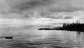
Point Atkinson looking up Howe Sound
![[The wedding party of Miss Elizabeth C. Lawson and Mr. W.J. Pitman]](/uploads/r/null/f/b/fb3aef4f232e343375ea1d41bcbcc19c7d4be079d890401633abe20a08e98352/9bdd17b0-8e87-4a9e-b776-07b118bf425a-A26829_142.jpg)
[The wedding party of Miss Elizabeth C. Lawson and Mr. W.J. Pitman]
![Clearing on the Marine Drive [at] Hollyburn West Vancouver](/uploads/r/null/8/9/8909034c58129aab3d83749957c381275aedf9d529ca72d94e31853f6c91fb6d/bc61caec-280a-4abd-a9bf-da3e6fb175b4-A26827_142.jpg)
Clearing on the Marine Drive [at] Hollyburn West Vancouver
![[Mrs. Henry Roome McDonald]](/uploads/r/null/d/7/d7cfd1a6796a1628f7b781aa49df76830fa8ca73799e7fda12c9c572fcfb2d3c/89dd4fd0-2945-40c7-a217-904a4f41d48d-A61944_142.jpg)
[Mrs. Henry Roome McDonald]
![[The wedding party of John Lawson's daughter outside Navvy Jack's house]](/uploads/r/null/8/2/82c0b2c341033e2b72f7d96d8a773c07b0e3eb8396736a85ee23d0dd969cfa00/d15396d8-bd47-4d09-a238-6b950dd67e20-A26822_142.jpg)
[The wedding party of John Lawson's daughter outside Navvy Jack's house]

Hollyburn Golf Course, West Vancouver
![[Mr. and Mrs. Fred Rogers and their daughter Mina camping at Point Atkinson]](/uploads/r/null/1/0/107a12383288d11c1809d4c47b62a829b510a616c149f6c66df931677b858758/cea37e6a-ed39-4dc9-a566-c9e6ceeed5ff-A62063_142.jpg)
[Mr. and Mrs. Fred Rogers and their daughter Mina camping at Point Atkinson]
![[The second Point Atkinson Lighthouse]](/uploads/r/null/b/9/b9e177ee1ce9f57b4511f889b52cdc17371e5c62bd8436b25100c835f3ff9f3b/ebb69d73-121f-4ef6-a07e-0f59ccc800db-A33178_142.jpg)
[The second Point Atkinson Lighthouse]
![McNair Fraser logging camp [at] Hollyburn](/uploads/r/null/6/1/6127900d60495b36275d2030b34833c0def918d3be9decbb28759fee910cb52e/d4084822-050b-4a5a-9c65-a7966aa8799d-A32031_142.jpg)
McNair Fraser logging camp [at] Hollyburn
![McNair Fraser logging camp [at] Hollyburn](/uploads/r/null/4/3/438cb9f3ea9ffba41568e3e2b27fcc09e3edc5e1ce64634bd8622bb56e1b6c35/1ae97068-fc03-444d-b48f-f4d8a9a5c325-A32033_142.jpg)
McNair Fraser logging camp [at] Hollyburn
![McNair Fraser logging camp [at] Hollyburn](/uploads/r/null/9/5/9504fc2db10f851a409b0fded43f3e4434d228862b93ccb189f03c60fd2a9fce/43afe828-9389-4e86-b2c2-146d337bd4c0-A32034_142.jpg)
McNair Fraser logging camp [at] Hollyburn

Map of West Vancouver and vicinity
Map of West Vancouver and vicinity
Map of West Vancouver and vicinity
Map of West Vancouver and vicinity : verso
![McNair Fraser logging camp [at] Hollyburn](/uploads/r/null/d/f/df98bb47791ed76d78beee034253482dcb66148b28f352e3289d25a185769866/660f484b-cba6-45fa-a4ef-cb33fa46a1d2-A32000_142.jpg)
McNair Fraser logging camp [at] Hollyburn
![McNair Fraser logging camp [at] Hollyburn](/uploads/r/null/9/6/96f318e3c66fe037dbd471ce8683420a317a3e095ee637731af77c685232395c/cbfa4cb6-3e4e-45ed-9783-d31ebed73692-A32032_142.jpg)
McNair Fraser logging camp [at] Hollyburn
![McNair Fraser logging camp [at] Hollyburn](/uploads/r/null/1/7/17c669b5ffa8e697789ca2d41a25676250c3548ba8c425892509d5b2d825c0a1/3807a641-f32e-4e62-9614-a499d8116603-A32035_142.jpg)
McNair Fraser logging camp [at] Hollyburn
![[View of Howe Sound from West Vancouver]](/uploads/r/null/6/4/649341c49f83c72c9ccc5752e4c240ed18f92e388317fd2b92d6ea158284ac0e/b8fa4789-0f52-40e6-9c28-3e7d116bf973-A36138_142.jpg)
[View of Howe Sound from West Vancouver]
![Chas [Charles] Nelson Reeve 1912](/uploads/r/null/6/1/6141998a6e70e75c3c11db1b09bff968dd4668e1cb32ae457707e154d8e9d421/82bbcfdf-853b-4a46-bc4d-a3d427f7b033-A35780_142.jpg)
Chas [Charles] Nelson Reeve 1912

Looking up Lawson Avenue Hollyburne B.C.

[Hollyburn General Store, post office and Navvy Jack's house on the corner of Lawson (17th) Avenue and Marine Drive]
Indexed guide map of the City of Vancouver and suburbs
Indexed guide map of the City of Vancouver and suburbs
West Vancouver
West Vancouver

Wreck on the Pacific Great Eastern Railway (at mile 6.5 North Shore District, P.G.E.R. 1 1/4 miles west of Dundarave)

Wreck on the Pacific Great Eastern Railway (at mile 6.5 North Shore District, P.G.E.R. 1 1/4 miles west of Dundarave)
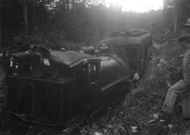
Wreck on the Pacific Great Eastern Railway (at mile 6.5 North Shore District, P.G.E.R. 1 1/4 miles west of Dundarave)
![[Point Atkinson lighthouse]](/uploads/r/null/f/5/f508b4c86166edb5ce8fc619cb3b583115a9beee6de98ea2826865034da83342/10b29b7c-c514-41cd-99a7-af14b6fc65aa-A33424_142.jpg)
[Point Atkinson lighthouse]
![[Collapse of the Capilano Creek (River) bridge]](/uploads/r/null/6/e/6e56ae40a9fe4beb643b20db36a23c99034bb5f5a8d8eb18f935c186e10e3669/4fc2c8f4-5dc5-407a-b666-2d1f686edd49-A63120_142.jpg)
[Collapse of the Capilano Creek (River) bridge]

Ralph Nickson
![Mae [Nickson] pensive](/uploads/r/null/9/1/9/919aa606a6b9c6a280067e3185625c4feb1ba1cce305100319e86fc8d55a7576/aac4fa4d-9b47-40a2-b1cc-907dca6f7bef-CVA289-002_142.jpg)
Mae [Nickson] pensive
![Mae and Ralph [Nickson]](/uploads/r/null/6/6/9/669a7d7deb9330f7c58e9e331d8379d3837bc981cec65ab6e9a5ea2db8ccca9a/890ed465-9809-4cf5-9beb-c1020dc16160-CVA289-002_142.jpg)
Mae and Ralph [Nickson]
![Mae [Nickson]](/uploads/r/null/6/6/f/66f46a665ee24bc8352c2192c7605dfdfc072c1e419ab0e399c26e1f14a6b067/06e3d83d-efff-452a-bfb4-b34f7b617679-CVA289-002_142.jpg)
Mae [Nickson]
![Mae [Nickson] on Cypress Creek](/uploads/r/null/7/1/c/71c29b8c7cab0d107c00cd4fe148de171f3a7d20cf26eefff60f344c219b1be4/3c94e7b8-6d82-411e-968e-e039c50a83ad-CVA289-002_142.jpg)
Mae [Nickson] on Cypress Creek
![Mae [Nickson] and Lois [and two men]](/uploads/r/null/c/c/2/cc21217347899a234f326138d5ef7cb179cb19f1ca1433a06e96a20ba40cb2ee/fc756ed3-42b7-4a11-ac72-45106731e6a4-CVA289-002_142.jpg)
Mae [Nickson] and Lois [and two men]

Norman Campbell and Lois
Looking west from North Vancouver towards Cypress Point Cannery