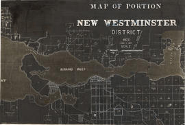
Map of portion New Westminster District
- AM1594-: MAP 1055.02
- Item
- 1877 (copied 1954)
Part of City of Vancouver Archives technical and cartographic drawing collection
Item is a heavily-amended copy of a map illustrating intended land settlement and subdivision in 1877 in the future sites of Vancouver, Burnaby and the North Shore, from an area bordering on English Bay to an area bordering on North Arm. Also shown are bodies of water, Hastings & Granville Road, and the settlements of Hastings and Granville. Annotations by J.S. Matthews in 1954 made on the copy are tracings in white pen and darkening the background to improve the copy.


![[Students of the first public school near the southeast corner of Edmonds Street and Douglas Road]](/uploads/r/null/b/6/b623f88197af9f78121fd65e2ea78e5d5ef265a3ed8922be9b90624ddaf36416/f83d66a8-ea25-40ad-9175-18f6bf1eccdf-A36438_142.jpg)
![[School officials on the steps of the first public school in Burnaby]](/uploads/r/null/e/4/e4c74adb8c1512642abb8350b319a711ee6f09bb5858d0467f19ab1e9ee45196/90f1c650-f8a4-480f-879d-361d2c010c62-A34150_142.jpg)

![[Douglas Road (Rayside Avenue) looking north]](/uploads/r/null/4/d/4d52a8aed44740308e2a7ca55478fd05921a239f3892f5e7a96856346a3e29c6/f157b48d-5e44-420a-a952-b5f67d8bd04f-A37241_142.jpg)
![[The first Presbyterian church on Westminster Road at Central Park]](/uploads/r/null/7/a/7af7e066a5a36137b09777bf14ef138d65e57624fe108c4c17162c7b38d3470b/0d21bdb9-1ecb-4d5a-9629-16a1bff50a2c-A25564_142.jpg)
![[Exterior of St. John the Divine Anglican Church on Westminster Road at Central Park]](/uploads/r/null/d/2/d2720bdac75f468556cf56eb2b92018a67b2451692cd06072db0f64bf6b51ed3/2f13ed60-d787-49bc-967d-7688dc394a64-A25565_142.jpg)
![[British Columbia Rifle Association members at the Central Park Rifle Range for annual match]](/uploads/r/null/9/5/9531538cf4d32d9e20698dd78b0f1af9fb932eac9a25b543196a6e078649feb1/56913a82-43dc-454b-8c04-a70337fb1b26-A32497_142.jpg)
![[Annual Westminster match at the Central Park Rifle Range]](/uploads/r/null/2/c/2c8b2acb5c6277ff563e3aea695d43168033fccdeaaa20bf0ea151f0330c4682/d3ef65fc-60c7-4078-af21-84ea5c0e08ec-A32313_142.jpg)
![[2nd Battalion, Canadian Garrison Artillery compete at Central Park Rifle Range]](/uploads/r/null/e/d/ed373b532ddf43ebb4568031ccd93e60d34b595845406b5efe1ccf2e394a2429/02547e56-e350-4173-a311-163dfbc479a4-A32257_142.jpg)
![[2nd Battalion, Canadian Garrison Artillery at the Central Park Rifle Range]](/uploads/r/null/c/0/c00678e6d1d593863ca035339e909b771b5601ba9e8b6c3fae91991f90a7ad2c/4747a6d6-898b-48a6-ab0f-ce917ef7aeb3-A32346_142.jpg)
![[The 2nd Battalion, Canadian Garrison Artillery at Central Park Rifle Range]](/uploads/r/null/1/5/15534f2bbf9bead05a9d594322ee886c2498228fd43fb14e44d4de5d333b7bfe/a7f58baf-0ab5-44ef-b9ee-83bdcd3fdde9-A32064_142.jpg)


![[Westminster Road (Kingsway) looking east from Boundary Road]](/uploads/r/null/5/d/5da4af5ec085796774a1b8269832b836f02cb0a4f9a9deacd20718c54e6b4d37/a97b486d-8050-4dd0-978d-152bf99e93b5-A37340_142.jpg)

![Vosper family [picnic at] Central Park, Burnaby](/uploads/r/null/8/9/89714d628e424ad367b23f09ad40444685744da1a6a4e102e83873b327789172/b96b427e-40a3-451c-b97f-f4db4a98cb24-A02229_142.jpg)


![[Loggers near Still Creek]](/uploads/r/null/e/4/e422eea84093cdd1d22ef41dff60b07b65343e3aaa8037bdadc6a07b42a28f87/6c042342-d990-4b3a-9645-4da5e84a03b3-A31961_142.jpg)
![[A match at the Central Park Rifle range]](/uploads/r/null/0/9/098a9023e7ef308623e91ed4323c8b1764bc0cce99ea2f518c69dff34c76bd5d/1daf7443-9935-4b3d-b369-efb7f9b1e5bc-A32344_142.jpg)
![[Men in front of the hut at the Central Park Rifle Range]](/uploads/r/null/3/6/361098d623eddb2f54bed456f8f32657dc5a8c75c65f87cf652a279bea49cd7d/d6d27cbe-fa5c-46f6-83ee-6c8c66668a7a-A32345_142.jpg)

![[Bear shot at Burnaby Lake]](/uploads/r/null/6/c/6cadd7716bc4db158890e6d6184093ca6974befb7e9a9396ec74f37ad8f203d6/fcfad3c4-45bb-4444-b850-58e9eafa440e-A26951_142.jpg)
![[Bear shot at Burnaby Lake]](/uploads/r/null/9/1/9133496a43dbc578cae1c7b698d8500c8b53609d398cd4247bd1eb9b07cffe5a/43fa8de8-2dff-4890-8242-a79a3eaabd1c-A26952_142.jpg)
![[Walter Lewis and a display of ducks]](/uploads/r/null/b/1/b14e5e1f7611fc05e24e03c9c7179410b2b25f4e1e97a657ba6ceee98d22c020/8dbf8fb1-d63d-4bf3-8625-c1f12a4ead00-A26954_142.jpg)
![[Hunters and animals shot at Burnaby Lake]](/uploads/r/null/6/5/65bc9e940e02011a09f444d4e5c61e716c4b04368215c2a3fd3b77883ed35eab/cd0e98a1-71ad-43b1-8172-ee12e081d4a1-A26956_142.jpg)
![[Wild cat shot at Burnaby Lake by Walter Lewis]](/uploads/r/null/c/7/c702cb756232104ea66147ae1096e87119a9822a50345a4ec40a3be204acbcc2/d283eaf8-8b1a-4a90-bd50-181584e0f3ee-A26953_142.jpg)
![[Hunters and animals shot at Burnaby Lake]](/uploads/r/null/5/2/52b4d174f704f5e4c79493a3c5697d1ac076d3c960d07f393f0b73fd2df1d778/05e1c1a7-a154-484d-8c75-6305c4620a77-A26876_142.jpg)
![[Hunters and animals shot at Burnaby Lake]](/uploads/r/null/3/e/3ed611946dd8af7aa827b548ae1071258206fbcbf6ac483b450fa90cd23ebbb2/6944e3a7-d0b2-4ae2-9c48-5b0ae6bd4548-A26955_142.jpg)
![[Bear shot at Burnaby Lake]](/uploads/r/null/5/1/51808ba7bfa1f41d0aa183a7b8153ad625afcf5b3abfe685645dd788ac64cd6c/8b75d39a-4262-48f2-b830-be542eab76c1-A26950_142.jpg)
![C.J. Piper's cottage [at] Piper [Avenue] North Burnaby [south of G.N. tracks]](/uploads/r/null/9/a/9a3383533a82a10784f197733a8bbe77d594580610fe4d659cc365be4f3bd7ee/a443bbf3-a683-4860-81b7-20db56c2cfcf-A46620_142.jpg)
![[View of Walter V. Bainbridge's ranch from Burnaby Lake]](/uploads/r/null/f/8/f83e27eeb6df5ffe2f00f65f295743c655cd822989310631971439da8226b178/d8425ba4-87e8-41de-b392-77c328f25014-A26941_142.jpg)
![[The wreck of Great Northern Railway train and engine No. 202 near Burnaby Lake]](/uploads/r/null/8/c/8c120a4630e58ec6d8ede7b74872a099c2d81d36816091c5d03a7f59f92b5a8d/05948ab1-0906-4e2d-adcd-79b1683f14b6-A62610_142.jpg)
![C.J. Piper's cottage [on] Piper [Avenue] North Burnaby south of G.N. tracks](/uploads/r/null/7/4/74c4ace93d1630f4d7e6731aa8a13ebff0f61bb1aedb18c09022c4149782ef62/6b4d01af-231f-4c66-9be0-fe8c5a706956-A46621_142.jpg)

![C.J. Piper's cottage [on] Piper [Avenue near] Burnaby Lake](/uploads/r/null/5/a/5afaa36920167f8ea5bae3dbea35cb9278c732e2acb87068462fe7f2c7b36866/47ff0806-eaa5-4cc5-bbf2-f1de5a74120c-A46622_142.jpg)


![Piper Mill, Piper Siding [near] Great Northern Railway](/uploads/r/null/1/d/1d9a0aba9c7f1ffd1a3f41724bc058318e250a59b4b2f4d41d42f9149bb900be/c48c5164-6f25-491b-99a1-51422353e29c-A46626_142.jpg)
![Piper Mill, Piper Siding [near] Great Northern Railway](/uploads/r/null/c/9/c90e447850ff00fc2c98215222bc129f027332096635eb40c3fc528ed17fb5ae/270dc2c7-b4a4-43b7-b16f-931ca52bcf05-A46627_142.jpg)