Item is a map depicting an area bounded by the following streets: Blanca Drive to English bay to the northeast corner of the University Endowment Lands to Fourth Avenue.
Item is a map depicting an area bounded by the following streets: Ontario Street (west side only) to approximate location of modern West 69th Avenue to Fremlin Avenue to the Fraser River.
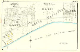
Item is a map depicting an area bounded by the following streets: Shaughnessy Street to Townsend Road [now West 70th Avenue] to east portion of District Lot 317 to the Fraser River.
Item is a map depicting an area bounded by the following streets: Ontario Street to Essex Street/Sixty-first Avenue West to Fremlin Avenue to Townsend Road [now West 70th Avenue].
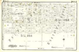
Item is a map depicting an area bounded by the following streets: Fremlin Avenue (west side only) to Buckberry Road [now Park Drive] (south side only) to east portion of District Lot 317 to Townsend Road [now West 70th Avenue] (north side only).
Item is a map depicting an area bounded by the following streets: Ontario Street to Fifty-first Avenue to Oak Street to approximate location of modern West 61st Avenue..
Item is a map depicting an area bounded by the following streets: Oak Street (west side only) to appoximate location of modern West 53rd Avenue to approximate location of modern Maple Street to approximate location of modern West 61st Avenue.
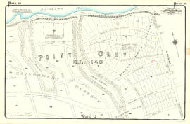
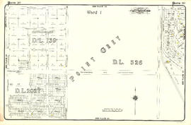
Item is a map depicting an area bounded by the following streets: Ontario Street to appoximate location of modern West 39th Avenue to Oak Street to Forty-ninth Avenue (Point Grey)/Fifty-first Avenue (South Vancouver).
Item is a map depicting an area bounded by the following streets: Oak Street to approximate location of current West 43rd Avenue to approximate location of current Maple Street to approximate location of current West 53rd Avenue.
Item is a map depicting an area bounded by the following streets: approximate location of current Maple Street to Forty-ninth Avenue (south side only) to Carnarvon Street (east side only) to approximate location of current West 54th Avenue and western edge of District Lot 325A.
Item is a map depicting an area bounded by the following streets: Carnarvon Street (west side only) to Fifty-first Avenue (south side only) to Fraser River to Bruce Street [now Wallace Street]/Musqueam Reserve.
Item is a map depicting an area bounded by the following streets: Maple Street (west side only) to Thirty-ninth Avenue (south side only) to Carnarvon Street (east side only) to Forty-ninth Avenue (north side only).
Item is a map depicting an area bounded by the following streets: Carnarvon Street (west side only) to Forty-first Avenue (south side only) to Crown Street (including two lots immediately west and northeast corner of Musqueam Reserve) to Fifty-first Avenue (north side only).
Item is a map depicting an area bounded by the following streets: Ontario Street (west side only) to Twenty-ninth Avenue to Oak Street (east side only) to approximate location of current West 39th Avenue.
Item is a map depicting an area bounded by the following streets: Oak Street (west side only) to Thirty-third Avenue (south side only) to Cypress Street (including 2/3 block immediately west) to Forty-third Avenue (north side only).
Item is a map depicting an area bounded by the following streets: Ontario Street (west side only) to Nineteenth Avenue West (south side only) to Oak Street (east side only) to Twenty-sixth Avenue/Twenty-fifth Avenue (north side only) and north part of District Lot 526.
Item is a map depicting an area bounded by the following streets: Oak Street (west side only) to Laurier Avenue/Matthews Avenue (south side only) to Cypress Street (including 1/2 block immediately west) to Thirty-third Avenue.
Item is a map depicting an area bounded by the following streets: Maple Street (incluing 2/3 block immediately east) to Twenty-ninth Avenue (south side only) to Carnarvon Street (east side only) to Thirty-ninth Avenue (north side only).
Item is a map depicting an area bounded by the following streets: Carnarvon Street (west side only) to Thirty-first Avenue (south side only) to Government Reserve to Forty-first Avenue (north side only).
Item is a map depicting an area bounded by the following streets: Maple Street to Nineteenth Avenue/18th Avenue to Carnarvon Street (east side only) to Twenty-ninth Avenue (north side only).
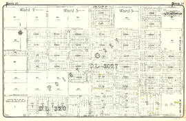
Item is a map depicting an area bounded by the following streets: Carnarvon Street (west side only) to Twenty-first Avenue (south side only) to Camosun Street (east side only) to Thirty-first Avenue (north side only).
Item is a map depicting an area bounded by the following streets: Oak Street to Thirteenth Avenue West (south side only) to Cypress Street (and 1/2 block immediately west) to Matthews Avenue and Laurier Avenue (north side only).
Item is a map depicting an area bounded by the following streets: Maple Street (including 1/2 block immediately east) to Eighth Avenue West (south side only) to Carnarvon Street (east side only) to Nineteenth Avenue West (north side only).
Item is a map depicting an area bounded by the following streets: Carnarvon Street (west side only) to Tenth Avenue West (south side only) to Crown Street (including 1/2 block immediately west) to Twenty-first Avenue (north side only).
Item is a map depicting an area bounded by the following streets: Carnarvon Street (west side only) to English Bay to Crown Street and Federal Government Reserve to Tenth Avenue West (north side only).
Item is a map depicting an area bounded by the following streets: Crown Street (west side only) to Sixth Avenue (south side only) to Blanca Drive (east side only) to Sixteenth Avenue (north side only).
Item is a map depicting an area bounded by the following streets: the northwest corner of District Lot 176 to English Bay to Blanca Drive (east side only) to Sixth Avenue (north side only).


![Plate 45: Eburne [Fremlin Avenue - Buckberry Road - DL 317 - Townsend Road]](/uploads/r/null/5/5/9/5598cfd0ce990ca7fe898ca616c8d59032103fcbbb1ac971f056446b55c6f85c/969c2d6f-977a-423a-a251-279ae90cd87b-MAP342a_142.jpg)

![Plate 43: Point Grey [Oak Street - Fifty-third Avenue - Maple Street - Sixty-first Avenue]](/uploads/r/null/0/1/2/0128f370e81c187f858e4dd8d1c56123f245fac386e61c2814dac4e42c3fb5e1/2d462a46-87dc-44f5-892d-bf76b2a0c867-MAP342a_142.jpg)

![Plate 41: Point Grey [Oak Street - Forty-third Avenue - Maple Street - Fifty-third Avenue]](/uploads/r/null/5/c/4/5c49ce9e62c8124e60724ba4658ef672c9a8577a72b7470712e755f225e5e53c/40c68f07-c590-4dd6-8980-19dae2c185f8-MAP342a_142.jpg)


![Plate 38: Kerrisdale [Maple Street - Thirty-ninth Avenue - Carnarvon Street - Forty-ninth Street]](/uploads/r/null/8/8/7/8877319961d5b79d8baacd1f17610d932fc144c32cdc4d51c091b6508e5f91ac/5003435f-0706-4579-9683-4be095514a59-MAP342a_142.jpg)
![Plate 37: Point Grey [Carnarvon Street - Forty-first Avenue - Crown Street - Fifty-first Avenue]](/uploads/r/null/e/5/4/e5420c03d3bc5ab6f2d354bd06f0606912e9fbc9a52335a42088fc2aaa6f0ffb/2b4101b5-1a7c-4531-9dca-881ac9509984-MAP342a_142.jpg)

![Plate 35: Shaughnessy [Oak Street - Thirty-third Avenue - Cypress Street - Forty-third Avenue]](/uploads/r/null/6/b/0/6b0eae693375c4dfe3401f5cd39a61247d72c892fbca308e4ddc56acb16a5ad1/2f2c15a3-f282-4f2f-b8f7-a655cf488ae9-MAP342a_142.jpg)


![Plate 29: Point Grey [Carnarvon Street - Twenty-first Avenue - Camosun Street - Thirty-first Avenue]](/uploads/r/null/3/6/d/36d64967233ead79fd5a60377f3c5e17df446e8fb639b21ee7558cddfd00f3ab/d5368109-f547-4d50-8e11-9e2ddea49dec-MAP342a_142.jpg)

![Plate 24: Kitsilano [Maple Street - Eighth Avenue - Carnarvon Street - Nineteenth Avenue]](/uploads/r/null/b/a/0/ba0d68b19000d99c14b892626e97bedc7f45445a348eb8777d39028478ac4859/2cc1981f-874e-400e-9af5-afe630d81ebd-MAP342a_142.jpg)
![Plate 23: Kitsilano [Carnarvon Street - Tenth Avenue - Crown Street - Twenty-first Avenue]](/uploads/r/null/c/b/9/cb9d797daebe3c23cc3ba0e3ab52ab602fa9dc4a36711e52ea66b2f98545e1ba/5287ebc9-ddb6-4554-a8ca-501a8cdcfd50-MAP342a_142.jpg)
![Plate 21: Kitsilano Carnarvon Street - English Bay - Crown Street - Tenth Avenue]](/uploads/r/null/4/2/8/428f96578655c794d997e5a6ff5007ddbcabb876cb06f8aec6efe8db1ca589dc/d66a7b24-0eaa-47f3-bfa5-0a39a8ee9943-MAP342a_142.jpg)
![Plate 20: Point Grey [Crown Street - Sixth Avenue - Blanca Drive - Sixteenth Avenue]](/uploads/r/null/e/7/1/e7131a5080595ea160953fc209124d18fa23d64a87bff5a9e09a0f0548c21440/2ad33d97-773a-48a1-935e-20d3599a75b0-MAP342a_142.jpg)
![Plate 19: Point Grey [DL 176 - English Bay - Blanca Drive - Sixth Avenue]](/uploads/r/null/9/0/9/909403abc0abc4ea9b01b1fe9828873551fc26e82dc2e7e8f84af526c1a137b6/34b7af86-7d81-4ed5-9c84-a350059fc9b2-MAP342a_142.jpg)