
- COV-S346-F01-: MAP 1121b
- Item
- [1923?]
Part of City of Vancouver fonds
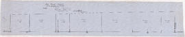
Item is a map sheet containing two profiles: one showing the increased reservoir height with a subsidiary dam built and the other a profile of the proposed subsidiary dam site.
6 results with digital objects Show results with digital objects
Part of City of Vancouver fonds
Item is a map sheet containing two profiles: one showing the increased reservoir height with a subsidiary dam built and the other a profile of the proposed subsidiary dam site.
Soo River profile from 6+3820 to 9+2380
Part of City of Vancouver fonds

Profile on possible dam sites across Soo River at 2+4340
Part of City of Vancouver fonds

Soo River profile from 9+2380 to 15+1650
Part of City of Vancouver fonds

Soo River profile from Green River junction west 6 miles 3820 ft
Part of City of Vancouver fonds

Profile dam no. 2 Soo River at 4+4980
Part of City of Vancouver fonds