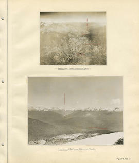
Item is a sheet containing the following survey photographs: Stillwater below Daisy Lake; Looking up Cheakamus River from canyon dam site; Leakage from Garibaldi Lake through lava into Garibaldi Creek; Looking up-stream from near Cheakamus Canyon power station; Looking up Cheakamus River from P.G.E. Rlwy. bridge Mile 19.1; Looking up Cheakamus River to Daisy Lake dam site; Looking down Cheakamus river from canyon dam site.
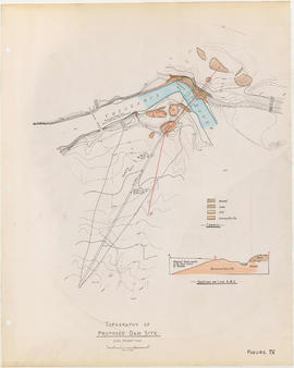
Item is a sheet with two maps depicting a possible dam site on the Cheakamus River: a topographical map of the site with the dam location annotated, and a cross-section depicting the geology of the dam site.
Item is a sheet with three maps depicting a possible dam site on the Cheakamus River near McGuire: a topographical map of the site with the dam location annotated, and a cross-section depicting the geology of the dam site.
Item is a sheet with three maps depicting a possible dam site on the Cheakamus River: a topographical map of the site with the dam location annotated, a cross-section depicting the geology of the dam site, and a profile of the tentative location of a tunnel.
Item is a copy of a Government of British Columbia Lands Department map which has been used as a base map to depict elements of the proposed development. Annotations depict acreages of affected areas.
Item is a topographic map of Cheakamus Lake, showing elements of the proposed power infrastructure. The map also includes an inset topographic map of the proposed dam site and a capacity diagram of Cheakamus Lake.
Item is a map depicting south-western British Columbia and noting the location of the area covered by the plates in the atlas. The sheet also includes a profile of the survey area from Cheakamus Lake to Garibaldi Lake.