City of Vancouver, British Columbia [sectional map]
- AM1594-MAP 779
- File
- [ca. 1935]-1945
Part of City of Vancouver Archives technical and cartographic drawing collection
File consists of three maps of Vancouver: an index map to the sections, an index map to District Lots, and 62 section sheets drawn and revised between ca. 1935 and 1945. Some time between 1946 and 1951 these maps were compiled and reproduced by the City Engineer's Office.
The 62 sectional plates are divided into three groups: the "Old City of Vancouver," Point Grey and South Vancouver. Maps show streets and roads, blocks, lots, legal descriptions, railways, parks, schools, hospital, cemetery, golf courses, retirement homes, and some businesses.
Vancouver (B.C.). Office of the City Engineer
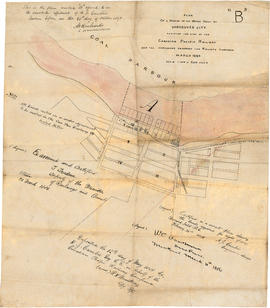


![[Map of Pioneer Place showing the area deeded to the City of Vancouver by the C.P.R.]](/uploads/r/null/4/1/41ba387b96586eb8554abcbf013c0e5cfbb116a42c8d1d1d2311fb1856694b2a/e3bd79d3-cd72-42e4-aa51-bc080514c205-MAP780_142.jpg)


