
Landscape - Bedding and borders : Formal garden
- AM1502-S1-2-: CVA 1502-1569
- Item
- Aug. 1980
17 results with digital objects Show results with digital objects
Landscape - Bedding and borders : Formal garden
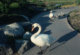
Wildlife : swan family on path, VanDusen Gardens

![Fothergilla monticola [at] UBC Alpine garden](/uploads/r/null/6/c/6c4e78370989f7135a17cade61f03891b644e14df257fb451599c2ddd5df655a/d596d8e9-560d-4700-90db-8365f543fcb1-A55864_142.jpg)
Fothergilla monticola [at] UBC Alpine garden


Laburnum vossi, color separations


![Rhus cotinus [launiata]](/uploads/r/null/d/8/d88ade9b7849c0d62f8fb43d18f5a8b349cd26f3916f35d9d726ce509a6a010d/18201996-3433-4ae0-9126-5bce8d92198e-A57484_142.jpg)


Environment : environmental protection, wilderness walkways

Part of Hubert William Lovell fonds
Sign is visible: "To Coal Harbour Road". Photograph was taken in the summer.
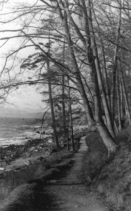
![[Intersection of two paths next to lake]](/uploads/r/null/d/7/d760c01663f15e6f1af48e61a82c1af04d6197b8648a69bf35efaee558f51a4f/c4f37f4c-993b-4d6e-adda-72cfecbc7cac-A02393_142.jpg)
[Intersection of two paths next to lake]
A note on the original accompanying envelope reads: "Stanley Park, a driveway, a pathway, and a tree."

Winter in the park, Vancouver, B.C.
Part of Major Matthews collection
Photograph shows a man walking down a snow covered trail.

Part of City of Vancouver Archives technical and cartographic drawing collection
Map shows present and proposed roads of the Lower Mainland and northern Washington State, as well as road repairs. Map covers the area from Point Grey to Hope and from Burrard Inlet to Bellingham Bay. Trails and roads indicated on the map include Telegraph Trail, Waggon Road and Pitt River Waggon Road, as well as several unnamed trails. Major bodies of water indicated on the map are Burrard Inlet, False Creek, Burnaby Lake, Pitt River, Fraser River, Sumas Lake, Sumas River, Chulukweyuk River, Harrison River, Boundary Bay, Semiahmoo Bay and Bellingham Bay. Place names are indicated throughout the map. 11T3 Roads & Trails is printed on the side of the map.

Part of City of Vancouver Archives technical and cartographic drawing collection
Map shows Hastings Town-site, Granville Town-site, Burnaby, and the City of New Westminster. Map also shows the Road from Granville and the False Creek Trail, as well as the names of places and soil types found along these roads. Other places and structures noted include Burrard Inlet, Coal Harbour (Coal Harbor on map), False Creek, False Creek Bridge, Burnaby Lake, Fraser River, New Westminster and Burrard Inlet Road, Douglas Road, Edinburgh Street, Columbia Street, Richards Street, and the New Westminster Cemetery. Two notes on map read "Plan to accompany Report of 1st May 1883, Joseph Hunter" and "Memo: Mr. Ross will place [?] this map to the [Engs.] Office Victoria [?]." 14T3 Roads & Trails is printed on the side of the map.