Showing 15 results

Archival description
Vancouver (B.C.) Real estate business
Print preview View:

6 results with digital objects Show results with digital objects

City of Vancouver : Canadian Pacific town site

Item is a map showing lot numbers and street names in Vancouver's West End from Boundary Avenue (now Glen Drive) in the east to Chilco Street in the west and Kitsilano (from First Avenue in the north to Fifth Avenue in the south and from Heather Street in the east to Vine Street in the west). The three inset maps are a map of "Canadian Pacific mail steamship lines" around the world, an "Index plan of Vancouver, B.C." and an "Index plan city limits".

City of Vancouver : Canadian Pacific town site

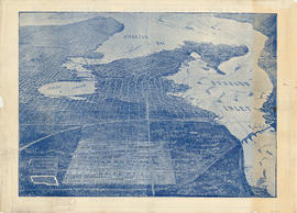
Primary map shows lot numbers and boundaries, streets, fire limits and "soundings in feet" (in English Bay, Burrard Inlet, Coal Harbour and False Creek) in downtown Vancouver, Stanley Park and parts of Kitsilano and Fairview. The ancillary maps show an "Index plan of Vancouver, B.C.", an "Index plan of [Vancouver] city limits" and "Canadian Pacific Mail Steamship Lines" (a map of Canadian Pacifc steamship routes around the world). On recto, the item also includes a description of Stanley Park and an illustration of Vancouver's inner harbour. On verso, the item includes descriptions of major Vancouver residences, imports, exports, businesses and other landmarks.

City of Vancouver : Residential lots, Area B, Champlain Heights

Item contains information on the sale of lots in Champlain Heights by the City of Vancouver. A map shows lot numbers, lot sizes, lot values and sidewalk crossings in the area from Rosemont Drive in the north to 63rd Avenue in the south and from Butler Street in the east to Kerr Street in the west, and text outlines the details associated with sales.

Map of Vancouver, B.C. including Hastings Townsite and D.L. 301

Item is a map which shows Vancouver city streets, blocks, parks and neighbourhood boundaries. Map includes Kitsilano, Shaughnessy Heights, West End, Fairview, Mount Pleasant, Grandview, Rosedale and Hyde Park areas. Map also indicates steamship, car and railway lines.

The map was originally designed to be folded and enclosed in a small folder to which it was attached.

Plan of provincial government property being a portion of townsite of Vancouver and sub-division of lot 540, group 1, New Westminster District, B.C., to be sold by public auction at Vancouver, B.C.

Item is a map showing lot numbers, lot boundaries, major streets and property sold or reserved in the area bounded by Campbell Street (Alma Street), present-day Trafalgar Street (unnamed on map), English Bay, and 16th Avenue.

Strategics Greater Vancouver Condominium Market Review - November 2000

File consists of one report on the condominium market in Greater Vancouver in 2000. The report includes the following sections:

  • 0.0 Summary
  • 1.0 Introduction
  • 2.0 Market Overview
  • 3.0 Project Overview
  • 4.0 City of Vancouver Market Areas
  • 5.0 Suburban Market Areas

In addition, the report includes details about condominium projects in the following geographic areas:

  • West End / Downtown
  • City of Vancouver West Side
  • City of Vancouver East Side
  • Burnaby/New Westminster
  • North East - Coquitlam / Port Moody / Port Coquitlam / Maple Ridge / Pitt Meadows
  • North Shore - North Vancouver / West Vancouver
  • Richmond / Delta
  • North Surrey
  • South East - South Surrey / White Rock / Langley