Showing 269 results
Archival description
Vancouver bicycle routes

Vancouver bicycle routes

Vancouver bicycle routes

Cycling in Vancouver
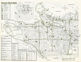
Vancouver bicycle routes

Cycling in Vancouver

City of Vancouver, B.C. area map : Inverness Street to Boundary Road 54th Avenue to the North Arm of the Fraser River

City of Vancouver, B.C. area map : Granville Street to Inverness Street and 6th Avenue to 37th Avenue

City of Vancouver, B.C. area map : Wallace Street to Cartier Street and 49th Avenue to the North Arm of the Fraser River

City of Vancouver, B.C. area map : western boundary with University Endowment Lands to Camosun Street and English Bay to 16th Avenue; Musqueam Indian Reserve no. 2

City of Vancouver, B.C. area map : Heatley Avenue to Boundary Road and Burrard Inlet to 2nd Avenue/5th Avenue

City of Vancouver, B.C. area map : Inverness Street to Boundary Road and 2nd Avenue/5th Avenue to 32nd Avenue

City of Vancouver, B.C. area map : Cartier Street to Inverness Street and 57th Avenue to the North Fork of the North Arm of the Fraser River

City of Vancouver, B.C. area map : Discovery Street to Granville Street and English Bay to King Edward Avenue

City of Vancouver, B.C. area map : Camosun Street to Granville Street and King Edward Avenue to 49th Avenue

City of Vancouver, B.C. area map : Maple Street to Heatley Avenue and Burrard Inlet to 6th Avenue

City of Vancouver, B.C. area map : Granville Street to Inverness Street and 37th Avenue to 57th Avenue

City of Vancouver, B.C. area map : Inverness Street to Boundary Road and 32nd Avenue to 54th Avenue

Vancouver parks

Vancouver Parks and Recreation : a guide to services
City of Vancouver, B.C.

Vancouver Parks and Recreation : a guide to services

Vancouver parks map

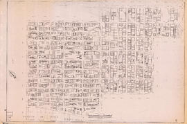
Sectional map of Vancouver showing streets, block and lot outlines, and building perimeters : Map 11 : Nanaimo Street to Rupert Street and Burrard Inlet to McGill Street

Sectional map of Vancouver showing streets, block and lot outlines, and building perimeters : Map 13 : Rupert Street to Boundary Road and Burrard Inlet to Eton Street

Sectional map of Vancouver showing streets, block and lot outlines, and building perimeters : Map 14 : Cassiar Street to Boundary Road and Eton Street to Pender Street

Sectional map of Vancouver showing streets, block and lot outlines, and building perimeters : Map 19 : Clark Drive to Nanaimo Street and Frances Street/Ferndale Street to 2nd Avenue

Sectional map of Vancouver showing streets, block and lot outlines, and building perimeters : Map 33 : Clark Drive to Nanaimo Street and 2nd Avenue to 13th Avenue
Sectional map of Vancouver showing streets, block and lot outlines, and building perimeters : Map 40 : Inverness Street to Nanaimo Street and 13th Avenue to 22nd Avenue/24th Avenue

Sectional map of Vancouver showing streets, block and lot outlines, and building perimeters : Map 42 : Oak Street to Ontario Street and 16th Avenue to 28th Avenue

Sectional map of Vancouver showing streets, block and lot outlines, and building perimeters : Map 43 : East Boulevard to Oak Street and 14th Avenue to Laurier Avenue

Sectional map of Vancouver showing streets, block and lot outlines, and building perimeters : Map 46 : Blanca Street to Discovery Street and 14th Avenue to 16th Avenue

Sectional map of Vancouver showing streets, block and lot outlines, and building perimeters : Map 49 : Arbutus Street to Oak Street and Laurier Avenue to 33rd Avenue
Sectional map of Vancouver showing streets, block and lot outlines, and building perimeters : Map 50 : Oak Street to Ontario Street and 28th Avenue to 37th Avenue

Sectional map of Vancouver showing streets, block and lot outlines, and building perimeters : Map 58 : Inverness Street to Berkley Street/Nanaimo Street and 41st Avenue to 49th Avenue

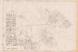
Sectional map of Vancouver showing streets, block and lot outlines, and building perimeters : Map 67 : Musqueam Indian Reserve and Shaughnessy Golf Course

Sectional map of Vancouver showing streets, block and lot outlines, and building perimeters : Map 69 : Wallace Street to MacDonald Street and 49th Avenue to the North Arm of the Fraser River

Sectional map of Vancouver showing streets, block and lot outlines, and building perimeters : Map 73 : Quebec Street to Inverness Street and 47th Avenue to 57th Avenue

Sectional map of Vancouver showing streets, block and lot outlines, and building perimeters : Map 75 : Nanaimo Street to Kerr Street and 49th Avenue to Bobolink Avenue

Sectional map of Vancouver showing streets, block and lot outlines, and building perimeters : Map 80 : Inverness Street to Gladstone Street/Nanaimo Street and 61st Avenue to the North Fork of the North Arm of the Fraser River

Sectional map of Vancouver showing streets, block and lot outlines, and building perimeters : Map 81 : Main Street to Inverness Street and 57th Avenue to S.E. Marine Drive

Sectional map of Vancouver showing streets, block and lot outlines, and building perimeters : Map 83 : Fremlin Street to Main Street and 57th Avenue to 67th Avenue/S.W. Marine Drive

Sectional map of Vancouver showing streets, block and lot outlines, and building perimeters : Map 90 : Iona Island to Wood Island and Celtic Avenue to Sea Island

Sectional map of Vancouver showing streets, block and lot outlines, and building perimeters: Map 5 : Lagoon Street to Nicola Street and Robson Street to English Bay
Sectional map of Vancouver showing streets, block and lot outlines, and building perimeters : Map 6 : Nicola Street to Beatty Street and Georgia Street to Beach Avenue/Drake Street

Sectional map of Vancouver showing streets, block and lot outlines, and building perimeters : Map 8 : Piers at Burrard Inlet between Main Street and Clark Drive

Sectional map of Vancouver showing streets, block and lot outlines, and building perimeters : Map 9 : Main Street to Clark Drive and Burrard Inlet to Prior Street

Sectional map of Vancouver showing streets, block and lot outlines, and building perimeters : Map 20 : Main Street to Clark Drive and Prior Street to 2nd Avenue/Great Northern Way
Sectional map of Vancouver showing streets, block and lot outlines, and building perimeters : Map 22 : Maple Street to Drake Street and Vanier Park/Sunset Beach to 4th Avenue

Sectional map of Vancouver showing streets, block and lot outlines, and building perimeters : Map 24 : Jericho Beach Park to Balaclava Street and English Bay to 4th Avenue
Results 1 to 50 of 269