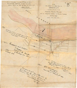
Canadian Pacific Railway. Plan of part of branch line from Port Moody. A point on main line C.P.R. to English Bay, B.C.
Plan of provincial government property to be sold at Victoria by public auction, Monday, January 18th, 1886
Advertisements for Vancouver real estate
Plan of a portion of the water front of Vancouver city
City of Vancouver : Canadian Pacific town site
Vancouver, B.C., the Pacific coast terminus of the C.P.R. [Canadian Pacific Railway]
City of Vancouver, Canadian Pacific Town Site
Vancouver, B.C., the Pacific coast terminus of the C.P.R. [Canadian Pacific Railway]
City of Vancouver
City of Vancouver : Canadian Pacific town site
192 : plan of Provincial Government property being a portion of Townsite of Vancouver and subdivision of Lot 540 Group 1, New Westminster District, B.C., to be sold by public auction
City of Vancouver. Fifth Sale. Lots and blocks in Lot 540
Plan of the City of Vancouver. Western Terminus of the Canadian Pacific Railway
Stuart's pocket map of Vancouver, B.C.
City of Vancouver
[Map of Pioneer Place showing the area deeded to the City of Vancouver by the C.P.R.]
Vancouver City : plan of Subdivision of lot 301, Group 1, New Westminster District
Map of the business portion of the City of Vancouver, British Columbia [early street paving]
Tourist guide map of Vancouver City and park
Panoramic view of the City of Vancouver, British Columbia, 1898
Tourist guide map of Vancouver City and Park
Map of Vancouver, New Westminster, Steveston and the Lower Mainland District
Municipality of North Vancouver [Burrard Inlet]
Plan of Provincial Government property being a portion of Townsite of Vancouver
South Vancouver
Plan of part of D.L. 540
Plan of the City of Vancouver
Vancouver, B.C. Plan showing location of water pipes, hydrants, etc. [Fairview slopes]
Vancouver, B.C. Plan showing location of water pipes, hydrants, etc. [Westminster Avenue to McLean Drive]
Vancouver, B.C. Plan showing location of water pipes, hydrants, etc. [West End]
Vancouver, B.C. Plan showing location of water pipes, hydrants, etc. [Victoria Drive to First Avenue to Prince Edward Street to 16th Avenue]
Vancouver, B.C. Plan showing location of water pipes, hydrants, etc. [Burrard Street to Gore Avenue]
Vancouver, B.C. Plan showing location of water pipes, hydrants, etc. [Kitsilano]
Vest pocket map of Vancouver : map C
Vest pocket map of Vancouver : map D
Vest pocket map of Vancouver : map B
Plate A [Index map of Vancouver - western portion]
Plate 105 [Front Street to False Creek to Quebec Street to Dufferin Street]
Plate 107 [Quebec Street to Dufferin Street to Manitoba Street to Fifth Avenue]
Plate 108 [Scotia Street to Front/Dufferin Streets to Quebec Street to Fifth Avenue]
Plate 109 [Victoria Drive to False Creek to Scotia Street to Fifth Avenue]
Plate 116 [Victoria Drive to Dufferin Street/Fifth Avenue to Scotia Street to Eighth Avenue]
Plate 118 [Burns Street to Seventh Avenue to Carolina Street to Tenth Avenue]
Plate 123 [Victoria Drive to Eigth Avenue to Scotia Street to Eleventh Avenue]
Plate 135 [Quebec Street to Fourteenth Avenue to Manitoba Street to Seventeenth Avenue]
Plate 140 [Block east of Pine Street to Kitsilano Indian Reserve to Cedar Street to Third Avenue]
![[Vancouver, B.C. : district lots]](/uploads/r/null/4/a/4a5c15633319c3754d3aa0cc525470bfebcf5a98ad8caeedf44b777194f300bd/2f055d65-47f7-4679-bb91-66b8f1843d2f-MAP531_142.jpg)


![Vancouver, B.C., the Pacific coast terminus of the C.P.R. [Canadian Pacific Railway]](/uploads/r/null/e/2/c/e2cdc004f3cf462100ed2ef053aa6087887b3f3200917cd5fba6292afb3b2d2d/bfcde3fa-32d7-4d08-86e5-ecf70c6f8388-LEG1340_142.jpg)

![Vancouver, B.C., the Pacific coast terminus of the C.P.R. [Canadian Pacific Railway]](/uploads/r/null/8/3/f/83fcf65f0d66d64e6357d0d647e0ea6e2fa4aae4c3d1919f952d7725b4299cda/623e750c-fbab-43b7-a496-d20b384baeb6-LEG1321_142.jpg)


![[Map of Pioneer Place showing the area deeded to the City of Vancouver by the C.P.R.]](/uploads/r/null/4/1/41ba387b96586eb8554abcbf013c0e5cfbb116a42c8d1d1d2311fb1856694b2a/e3bd79d3-cd72-42e4-aa51-bc080514c205-MAP780_142.jpg)

![Map of the business portion of the City of Vancouver, British Columbia [early street paving]](/uploads/r/null/7/1/7187f671d2770050eb87f7f397a10ea92bf0bc593b0a186e3a4bf341b3d26e42/8770145a-b925-4eef-82ac-e397f61a65aa-Map1163_142.jpg)


![Municipality of North Vancouver [Burrard Inlet]](/uploads/r/null/6/d/6d0d9a4b75b38672c56aa89a5984fe2d0e6d66be85f6f375cbe8e2fd7ac94a98/577914e1-3de2-478b-a629-5f391731387a-MAP588_142.jpg)


![Vancouver, B.C. Plan showing location of water pipes, hydrants, etc. [Fairview slopes]](/uploads/r/null/6/9/69e0d6904facfa2a814069c15122fba46fc4d8077bff76402e95484a4b13d4d8/313b8940-1e98-45d4-b077-abe0f6bee66a-MAP72_142.jpg)

![Vancouver, B.C. Plan showing location of water pipes, hydrants, etc. [West End]](/uploads/r/null/0/5/05354f71931ba85b05864a2adeb3580a6365ddf962e5084f0bb51c68608364a0/3f57f512-bd27-404e-a332-e0881405c2ac-MAP72_142.jpg)

![Vancouver, B.C. Plan showing location of water pipes, hydrants, etc. [Burrard Street to Gore Avenue]](/uploads/r/null/7/7/7797d041e72dece35da90eab6733a9db50a0b2115ad816578d3633a58bf31761/ebc0f54a-c23a-425c-816d-1dd268a2e4e7-MAP72_142.jpg)
![Vancouver, B.C. Plan showing location of water pipes, hydrants, etc. [Kitsilano]](/uploads/r/null/0/e/0e33cc4d2f081f551fe6919d35ea37236a6e237a2f5927834d275556995fccfc/0f6ac1ff-8457-41f3-a386-26328c66a4b0-MAP72_142.jpg)


![Plate A [Index map of Vancouver - western portion]](/uploads/r/null/0/d/0/0d022ba039f0508a397a4d35450b667671f0ef36fd388f800f51681434d2a2a9/795dc4f4-e794-4288-880d-6bd4de616417-1974-100_142.jpg)
![Plate 105 [Front Street to False Creek to Quebec Street to Dufferin Street]](/uploads/r/null/a/f/b/afbb9be25514350d408eefa5865173e3a489ecdb6752d6b3096564052b234ca4/8c126ea6-16bb-4f0b-8131-a16f2a686d95-1974-100_142.jpg)
![Plate 107 [Quebec Street to Dufferin Street to Manitoba Street to Fifth Avenue]](/uploads/r/null/0/d/7/0d79d0f2e59b2acf6f0b094b86112948aced989bd8c13eb8f8ac17f5cb05a1fd/b74906fe-c1a9-49b1-8bc5-37b4141108f6-1974-100_142.jpg)
![Plate 108 [Scotia Street to Front/Dufferin Streets to Quebec Street to Fifth Avenue]](/uploads/r/null/5/4/6/54625ed1d1a99824d0a91f9897950dc4d1691ce8f7fae7be8086e768e671ef0e/5da48b46-8a62-40b9-9992-0fcbe4e8b491-1974-100_142.jpg)
![Plate 109 [Victoria Drive to False Creek to Scotia Street to Fifth Avenue]](/uploads/r/null/c/f/7/cf796986affb1d4761889c3b98c83be508ab7b762a16dcde3f48354e496a910f/3e0ce046-091f-45fb-b3ec-8ef8d907b4c2-1974-100_142.jpg)
![Plate 116 [Victoria Drive to Dufferin Street/Fifth Avenue to Scotia Street to Eighth Avenue]](/uploads/r/null/a/4/8/a48d7c5927867042c40b8415d5b33492b6ba8385e375aec78a675f2d3859417a/0dac58ba-008b-4d37-8ea2-aabfd1cb96d8-1974-100_142.jpg)
![Plate 118 [Burns Street to Seventh Avenue to Carolina Street to Tenth Avenue]](/uploads/r/null/1/3/d/13d0f752a2256754eef1871ceaee111678790dfc9ac08ab3515e1d24051659bc/b001c220-4630-4f03-bbd4-e73eaafe8133-1974-100_142.jpg)
![Plate 123 [Victoria Drive to Eigth Avenue to Scotia Street to Eleventh Avenue]](/uploads/r/null/8/7/7/877219ac8c7a9bd7a9f4f1affe532e0433280f5133544dd5bc24ba78306876e9/3b86ff00-0f66-44a6-a2ca-f716bd507388-1974-100_142.jpg)
![Plate 135 [Quebec Street to Fourteenth Avenue to Manitoba Street to Seventeenth Avenue]](/uploads/r/null/e/2/c/e2cb462b960ca9d4c0d5b97180db2dd920b833da6c49e5d51c8e95bf106ef7db/87724ebf-1228-4869-bb46-03f26e327563-1974-100_142.jpg)
![Plate 140 [Block east of Pine Street to Kitsilano Indian Reserve to Cedar Street to Third Avenue]](/uploads/r/null/7/e/8/7e8970e4b38be59229b38f8b6eb9833bfce0ac4b6b5ab287ecc09ff682cebecc/42fb5df2-2281-4cc9-a83f-44f82f9e47c3-1974-100_142.jpg)