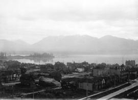
![[View of] Downtown from Cambie Bridge](/uploads/r/null/9/5/9569782086f72e1216c2b4c9677babe70ef361e9008444790951403f3fbd32d3/af222087-669e-456f-980d-947447a9da81-A58781_142.jpg)
[View of] Downtown from Cambie Bridge
- COV-S511---: CVA 780-1
- Item
- June [19]77
Part of City of Vancouver fonds
427 results with digital objects Show results with digital objects
[View of] Downtown from Cambie Bridge
Part of City of Vancouver fonds
![[Night view of the West End and] downtown from Broadway at Stephens](/uploads/r/null/1/7/1780d2870a5034926f4da263ba69643bb411bcdb2050ce6a0dedad07de1bbb6d/8e84be38-3ea9-4e8b-ac8a-054c51742272-A58783_142.jpg)
[Night view of the West End and] downtown from Broadway at Stephens
Part of City of Vancouver fonds
![[View of buildings from] Hastings St[reet] at Granville [Street]](/uploads/r/null/c/2/c27a7826be7b3190205fc70c42e70a63dc7135c8703a763b83348842015f18bc/5d3a5c8f-e032-4b03-ba6d-129b36323885-A58826_142.jpg)
[View of buildings from] Hastings St[reet] at Granville [Street]
Part of City of Vancouver fonds
Photograph also shows the General Post Office (757 West Hastings Street) and the Marine Building (355 Burrard Street)
![[View of tree stumps from the corner of 12th Avenue and Crown Street]](/uploads/r/null/b/4/b46306b5ca9bd13516353852a316fa079419824de41937d89065c29c0992a1ea/4c0f1f5c-1305-477e-84e5-b06450f49f67-A37077_142.jpg)
[View of tree stumps from the corner of 12th Avenue and Crown Street]
Part of Major Matthews collection
![[View of Vancouver from Brockton Point]](/uploads/r/null/f/a/faccb7ffd8899c4575efbc7fe8526b052ad52e140d1082bc00fa5a5d1597f7ea/be2271a1-9a6b-42f5-b151-9b6fa29ce75f-A43379_142.jpg)
[View of Vancouver from Brockton Point]
Part of Major Matthews collection
Photograph shows an Imperial Oil Company gasoline scow
![[View of Vancouver from Deadman's Island]](/uploads/r/null/a/0/a0850ee76e9744cd984cc88ad876a42f4e3b3b6130acd98c12f10174e1808a99/bb8f847f-b5b8-42f4-a859-d2fe95c65441-A43305_142.jpg)
[View of Vancouver from Deadman's Island]
Part of Major Matthews collection
Photograph shows the "Robert Kerr", and "Empress" ship and the S.S. "Manuense" and the C.P.R. station under construction in the background
![[View of Vancouver from Queen Elizabeth Park]](/uploads/r/null/3/c/3cfa35e93d85743dd1ad48a86ce5f0b71bf08e45929ae6991b6d8813a2f44495/3e6e8c12-9a55-4194-8e18-db2a1af348a9-A43278_142.jpg)
[View of Vancouver from Queen Elizabeth Park]
Part of Major Matthews collection
Photograph shows City Hall and part of Riley Park and The Lions
![[View of Vancouver from Queen Elizabeth Park]](/uploads/r/null/6/4/64860f27993ee170af0c59a78956705df453012e6ddceee2c220602e88a6b204/46c722f6-1a90-415c-a497-c66971f613f1-A43279_142.jpg)
[View of Vancouver from Queen Elizabeth Park]
Part of Major Matthews collection
Photograph shows City Hall, part of Riley Park and The Lions
![[Western view of Fairview from the tower of King Edward High School on 12th Avenue and Oak Street]](/uploads/r/null/5/7/57f78634c36cdc44896b928e95b888dc11481e391bcf511d52692a2ee6953e09/d4c21e48-ce87-44ed-8181-22199bd4fa93-A43281_142.jpg)
[Western view of Fairview from the tower of King Edward High School on 12th Avenue and Oak Street]
Part of Major Matthews collection
Photograph shows the C.P.R. Kitsilano Trestle and the Granville Street Bridges
![[View across Burrard Inlet toward English Bay from the foot of Trafalgar Street]](/uploads/r/null/6/3/63dcc142e99746062de179b6facfab6fccd8a86241823bbab31d3191a9b5b7c3/c30444a3-8e5d-41dd-b170-5eb3a69913df-A23675_142.jpg)
[View across Burrard Inlet toward English Bay from the foot of Trafalgar Street]
Part of Major Matthews collection
![[View looking northwest from the Hotel Vancouver]](/uploads/r/null/b/d/bdcd8bdfd65db0aec0be20ca80cd505d4e9abaea4b65e0e32bceee2e94a3053d/a2dd39f2-eb73-48e8-adb2-527495ce047e-A43229_142.jpg)
[View looking northwest from the Hotel Vancouver]
Part of Major Matthews collection
Photograph shows the Marine Building and Brockton Point and The Lions in the background
![[View looking west across Burrard Inlet from Prospect Point]](/uploads/r/null/9/4/9466f7028c9e35c004cb74395044c2b524f80f22f80421b1414f7df1dcb411ce/fe974e47-33ec-4d54-bd74-29b5a4080162-A43378_142.jpg)
[View looking west across Burrard Inlet from Prospect Point]
Part of Major Matthews collection
![[View of a tallship in Burrard Inlet]](/uploads/r/null/9/2/92d00298fa2f6f6aaceff11fadb35afcecef231612bb1c633e506d729822cca9/9c26a667-3e50-450d-9658-b074c28e6052-A43313_142.jpg)
[View of a tallship in Burrard Inlet]
Part of Major Matthews collection
![[View of Brockton Point from Coal Harbour]](/uploads/r/null/b/7/b72d0a91686983254a010ebe842ea27b32eadba8c953cb2acd8e3a52c2e70d97/e56e3de6-bcf1-4351-a837-fba28bb4e755-A43327_142.jpg)
[View of Brockton Point from Coal Harbour]
Part of Major Matthews collection
![[View of Deadman's Island after being clear-cut of trees]](/uploads/r/null/0/d/0d52bc123aeaf44551a219dde291611efbf6a9f8b49e80e436cdbf33322e2eec/184b970b-6838-4854-bb67-7cd007564196-A43283_142.jpg)
[View of Deadman's Island after being clear-cut of trees]
Part of Major Matthews collection
![[View of Downtown from City Hall]](/uploads/r/null/6/b/6b60b736823fa512f4b8a1edde2ba364e9c95d1270efe8fdfb102298a81de48a/9c8443d5-d9bb-4803-bf6a-9e6ade54a4d6-A43277_142.jpg)
[View of Downtown from City Hall]
Part of Major Matthews collection
Photograph shows the Hotel Vancouver, the clock tower of the Vancouver Block, the Hudson Bay store, the top floors of the Marine Building and The Lions in the background
![[View of Fairview looking north from approximately 15th Avenue and Wolfe Avenue]](/uploads/r/null/e/a/eaab56faf0a7b092c1ac2f048adeb38e5f96c84432579614999510acdc002f6b/67ead65e-0e9b-403c-a1c7-ba225e406161-A37252_142.jpg)
[View of Fairview looking north from approximately 15th Avenue and Wolfe Avenue]
Part of Major Matthews collection
![[View of Fairview looking west from City Hall]](/uploads/r/null/d/8/d87892f743f488ae9a2f5003bc53c8a5f283417a8d4193ff9f894feec2d06564/ee474602-8f4a-4cf4-9f70-7a60fb4e7bad-A43291_142.jpg)
[View of Fairview looking west from City Hall]
Part of Major Matthews collection
Photograph shows False Creek, the Burrard Bridge and Yaletown in the background
![[View of Lord Roberts School from the corner of Davie Street and Cardero Street]](/uploads/r/null/d/c/dcb35a1971ab94bb28b39ad66936cd399d259b48f014b86732fff2bd8ccbc631/f04d98d2-2cce-400f-a91e-12f6aeac1f08-A36984_142.jpg)
[View of Lord Roberts School from the corner of Davie Street and Cardero Street]
Part of Major Matthews collection
Photograph shows street car tracks
![[View of Mount Pleasant looking northeast from City Hall]](/uploads/r/null/0/0/00f3be8cb9dc06c9f844f78cf67bf5b62a3d09109caccd699ac683b4f47a90e4/a8fc3c83-fbc0-4050-8f98-ae95939608f6-A43292_142.jpg)
[View of Mount Pleasant looking northeast from City Hall]
Part of Major Matthews collection
![[The Coal Harbour bridge and Stanley Park from the foot of Denman Street]](/uploads/r/null/a/1/a1bf05bebdf6fb8514abdfe8611f2b0337fdceed37a071380f3bb7e8f7ffee09/3be9fbcd-5036-4469-86ae-1becd3c3e31d-A37355_142.jpg)
[The Coal Harbour bridge and Stanley Park from the foot of Denman Street]
Part of Major Matthews collection
![[Looking north from Nelson Street just east of Thurlow Street]](/uploads/r/null/0/6/063e02ba53aa134b2a656b0db324beaf3a4615ec417fb2ee32d3e3e226620699/5df3a239-9da3-49b5-ae6b-d0424948719a-A02567_142.jpg)
[Looking north from Nelson Street just east of Thurlow Street]
Photograph shows houses and apartment buildings (including the Manahattan Apartments), part of Brockton Point, the Burrard Inlet and the North Shore.

Vancouver, B.C. from City Hall

View of harbour from Bekins Bldg.

Part of Major Matthews collection
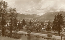
Photograph shows a northern view of Vancouver from Queen Elizabeth Park

Part of Major Matthews collection

Taken from the Top of the Hotel Vancouver - Brockton Point in the Distance
Part of Major Matthews collection
Photograph shows part of the 600 Block Howe Street and beyond from the first Hotel Vancouver
![[Looking north across False Creek from 8th Avenue between Alder Street and Spruce Street]](/uploads/r/null/b/f/bfbfdda073909ac3a8b7fe81c7d8a986770772ac8fdcfef25af14dca17a87a19/d7b8ac67-cd53-4df6-a8a2-3c59dcd146d8-A43223_142.jpg)
[Looking north across False Creek from 8th Avenue between Alder Street and Spruce Street]
Part of Major Matthews collection
Panoramic view showing Yaletown and the Fader Brothers sawmill
![[Looking north from Georgia Street from the Hotel Vancouver]](/uploads/r/null/1/d/1df3414322643e40b5acc7d56e4459100bf28fdaced597f35ed4e75df64ba4ac/0df1fdb6-c80d-4c32-8f32-132ce9ed158b-A43259_142.jpg)
[Looking north from Georgia Street from the Hotel Vancouver]
Part of Major Matthews collection
Photograph shows the 500 and 600 Blocks between Howe Street and Granville Street including part of the C.P.R. Park, Manor House and the Van Horne Block
![[Looking north near Centre (Granville) Street from Ninth Avenue (Broadway)]](/uploads/r/null/8/d/8d659bc5d10e183c5ff6d01732829796801d5b033fcb5da1a9722a00005f5b44/bf08d760-4da7-4fee-a5bd-0f10db8dc41e-A37097_142.jpg)
[Looking north near Centre (Granville) Street from Ninth Avenue (Broadway)]
Part of Major Matthews collection
![[Looking north on Howe Street from Dunsmuir Street towards North Vancouver]](/uploads/r/null/d/0/d0b6611f857cee211c55fa3eef752b25fa67c29908d0a87c081d71b426926df8/04a53bfe-4591-488b-994e-204c81af7bcf-A43240_142.jpg)
[Looking north on Howe Street from Dunsmuir Street towards North Vancouver]
Part of Major Matthews collection
Panoramic view showing the Marine Building under construction and part of Piers A and B-C
![[Looking northwest from Georgia Street from the roof of the Hotel Vancouver]](/uploads/r/null/d/f/dfaf6025b2fe67f9c498ec745761d9fdd050c67599166259c6f488dc73374095/8e488de0-a071-4eba-9b30-fe43c5351095-A43258_142.jpg)
[Looking northwest from Georgia Street from the roof of the Hotel Vancouver]
Part of Major Matthews collection
Photograph shows Deadman's Island and Brockton Point in the background
Part of Major Matthews collection
Photograph shows the west side of the 600 Block of Howe Street including Manor House
![[Looking west across False Creek from 7th Avenue and Birch Street]](/uploads/r/null/3/1/313ac14834d7064a141c7918b538a6c9c79ce7026237e479c697a3d0e4703dd4/1508bee7-942a-4268-94da-1baf5abecc12-A43222_142.jpg)
[Looking west across False Creek from 7th Avenue and Birch Street]
Part of Major Matthews collection
Panoramic view showing Granville Street Bridge and the C.P.R. Kitsilano Trestle Bridge
![[Northern view from Downtown towards North Vancouver]](/uploads/r/null/c/4/c4e11a8eb3deeb229ed4c8539e7289a1e13542dc6ac3473728390d68502f859d/b78c1952-8208-46b9-9aab-747d52e91072-A43284_142.jpg)
[Northern view from Downtown towards North Vancouver]
Part of Major Matthews collection
Photograph shows Brockton Point
![[Northern view from the tower of King Edward High School on 12th Avenue and Oak Street]](/uploads/r/null/c/6/c6a2098e8be2096dd153388c7cc69b6590ff14fcd374b1ac1f691ebf1dc50441/abe0536e-5915-41aa-9d09-95d6c9e97be5-A47183_142.jpg)
[Northern view from the tower of King Edward High School on 12th Avenue and Oak Street]
Part of Major Matthews collection
Photograph shows part of Fairview and False Creek, the Connaught Bridge and Yaletown in the background
![[Northern view of Fairview from the tower of King Edward High School on 12th Avenue and Oak Street]](/uploads/r/null/b/c/bc4f34ad9aa5a5bc18dec6ca7832786f8b77217c3729cf25944c96705a9e416a/32c6ae21-a7bc-452c-89be-9f78d8c1067f-A43282_142.jpg)
[Northern view of Fairview from the tower of King Edward High School on 12th Avenue and Oak Street]
Part of Major Matthews collection
Photograph shows False Creek and Yaletown, with the first Granville Street Bridge and Burrard railway trestle in the background.
![[Northern view of False Creek Flats from Mount Pleasant]](/uploads/r/null/4/c/4c21145a751d4755607fbd86dd1a02b6124e2a5073f3f6f876110310c5fabf21/0e75cede-a8b6-49ce-9be7-a64b95a7e3dd-A43285_142.jpg)
[Northern view of False Creek Flats from Mount Pleasant]
Part of Major Matthews collection
![[Northern view of the 600 Block between Howe Street and Granville Street from the Hotel Vancouver]](/uploads/r/null/f/f/ff1346527da8addf4e4ac2a5452cecc5e7730d9cf121286a4cc5d9efa6377496/f84fd027-2319-449c-8647-d7784d865359-A43293_142.jpg)
[Northern view of the 600 Block between Howe Street and Granville Street from the Hotel Vancouver]
Part of Major Matthews collection
Photograph shows the Van Horne Block, the Japanese Consulate, the Alhambra Theatre and the Bank of Montreal
![[Northern view of Westminster Avenue (Main Street) from 7th Avenue]](/uploads/r/null/e/e/eedf5dc6b5cf6caafadff512ec18cf952b58c3fe76cbe821bad2890dd36af4ad/ead53220-dc8f-4f5e-9654-b6cea29e57c4-A43237_142.jpg)
[Northern view of Westminster Avenue (Main Street) from 7th Avenue]
Part of Major Matthews collection
Photograph shows the Westminster Avenue Trestle Bridge and False Creek in the background
![[Fairview looking west across False Creek]](/uploads/r/null/5/3/530c1602976afb68dba7c39f098a0a2dd5b251f4f37cb95836fc30f1f5877280/8ef64e7f-ca79-41ee-b3cc-070bc0f90b28-A25939_142.jpg)
[Fairview looking west across False Creek]
Part of Major Matthews collection
Panoramic view showing the False Creek Indian Reserve, Granville and C.P.R. Kitsilano Trestle bridges and Edward Chapman's residence.
Part of Major Matthews collection
Photograph shows a view looking north from Queen Elizabeth Park. Part of a Christmas card commemorating BC's 1958 Centennial. Page of text with card
![[Aerial view from English Bay looking north]](/uploads/r/null/d/d/ddde8583daccecc78a9320298ee1ffd98d46ab0f6df0fb5a80a2e9b149444eeb/2b1a9267-8779-4253-95a0-145b5e2029a9-A61396_142.jpg)
[Aerial view from English Bay looking north]
Part of Major Matthews collection
Oblique view showing the Englesea Lodge, the West End, English Bay Beach, Coal Harbour, Deadmans Island, Brockton Point, the western section of Downtown and north Vancouver in the background
![[Aerial view of Downtown]](/uploads/r/null/1/d/1d3f6cb0fb1d1c4b0fbaff95c64f947cdc26d5ffaa6c212ae24596a4dd058682/394e8d98-3a08-405b-885e-173deb9ff8bd-A61433_142.jpg)
Part of Major Matthews collection
Oblique view showing Coal Harbour, Deadmans Island, Brockton Point and North Vancouver in the background

Part of Major Matthews collection
Photograph shows a view looking west from near the foot of Westminster Avenue (Main Street)

Part of Major Matthews collection
Photograph shows a view looking north from the corner of Westminster Avenue (Main Street) and 7th Avenue including the Westminster Avenue Trestle Bridge and False Creek in the background

Vancouver from Hastings Street
Part of Major Matthews collection
Photograph shows a northeast view from Richards Street
![Vancouver looking east from [Howe Sound]](/uploads/r/null/6/6/66fa4a6e8bb1ab5d20d8f951fa93ad57dd828be645aff6d182d88a8b36c69281/69bee6e1-54a6-4c8f-a7db-043e03b4dfe6-A23503_142.jpg)
Vancouver looking east from [Howe Sound]
Part of Major Matthews collection
Oblique view. Photograph shows Point Grey, University of British Columbia and University Endowment Lands.
Typewritten letter from Hunting Survey Corporation Limited on verso of print.

Vancouver's skyline by night as seen from Stanley Park across Burrard Inlet
Part of Major Matthews collection
Photograph shows three fuel barges

Vancouver, B.C. "The livest and most beautifully located city in Canada"
Part of Major Matthews collection
Panoramic view (280 degrees) taken from the dome of the World Building showing the Beatty Street Armouries, the Cambie Street Grounds, Central High School, Vancouver High School, the Dominion Building, the railway yards and the eastern industrial areas