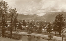
![[View of Deadman's Island across Coal Harbour from the foot of Cardero Street]](/uploads/r/null/5/6/56d8d0b586b06e59ff28fd3d94a2c551a0133573d8b69e4a4786080727097739/3e5a82d0-ea5e-4593-b4f5-89ba3654cfe6-A36274_142.jpg)
[View of Deadman's Island across Coal Harbour from the foot of Cardero Street]
- AM54-S4-1-A-29-: A-29-26
- Item
- [ca. 1895]
Part of Major Matthews collection
220 results with digital objects Show results with digital objects
[View of Deadman's Island across Coal Harbour from the foot of Cardero Street]
Part of Major Matthews collection
![[Looking east across Coal Harbour from the foot of Cardero Street]](/uploads/r/null/e/8/e81ed82ea275c71149094386b3048cfe85af88e4c950d2dbfd8fa3b089c394c9/7d237c33-2bf0-4f87-afe6-e277ee46d3b5-A36275_142.jpg)
[Looking east across Coal Harbour from the foot of Cardero Street]
Part of Major Matthews collection
Photograph shows British warships at anchor
![Vancouver looking east from [Howe Sound]](/uploads/r/null/6/6/66fa4a6e8bb1ab5d20d8f951fa93ad57dd828be645aff6d182d88a8b36c69281/69bee6e1-54a6-4c8f-a7db-043e03b4dfe6-A23503_142.jpg)
Vancouver looking east from [Howe Sound]
Part of Major Matthews collection
Oblique view. Photograph shows Point Grey, University of British Columbia and University Endowment Lands.
Typewritten letter from Hunting Survey Corporation Limited on verso of print.
![[View looking north from the Hotel Vancouver]](/uploads/r/null/6/4/64b11d9c89a741706ebda07c14cbe1bc9ddece32caf48e09dbd64d52e2f5720a/3a282884-5eb4-435d-8e82-9e8a07c575a5-A23504_142.jpg)
[View looking north from the Hotel Vancouver]
Part of Major Matthews collection
Photograph shows the Marine Building
![[View of Fairview looking north-west]](/uploads/r/null/b/8/b890c9794a5cc39f7be965d287b974abdbc0b3471106801fc91b109db2c3f5d7/15a9e9cc-16d2-4d24-a10b-08e0af9c6892-A23512_142.jpg)
[View of Fairview looking north-west]
Part of Major Matthews collection
![[View of Downtown and the waterfront looking north-east]](/uploads/r/null/6/c/6cff1e9ae582d985f97bb1d48994ec74d160cab5ed6f69ae8f590dd682ad09fd/e7b10570-966f-4553-a7d1-b8b1e1f9788b-A23513_142.jpg)
[View of Downtown and the waterfront looking north-east]
Part of Major Matthews collection
![[Northeast aerial view of Burrard Inlet and Vancouver]](/uploads/r/null/6/6/662502a43d6839b8b0b3518a2f22ca5822fc6dc224c73d5002c705655d5ab329/48aa6304-734e-41ed-8ef2-daffdac1a38d-A23488_142.jpg)
[Northeast aerial view of Burrard Inlet and Vancouver]
Part of Major Matthews collection
Oblique view
![[View across Burrard Inlet toward English Bay from the foot of Trafalgar Street]](/uploads/r/null/6/3/63dcc142e99746062de179b6facfab6fccd8a86241823bbab31d3191a9b5b7c3/c30444a3-8e5d-41dd-b170-5eb3a69913df-A23675_142.jpg)
[View across Burrard Inlet toward English Bay from the foot of Trafalgar Street]
Part of Major Matthews collection
![[Looking north across False Creek from 33 Dufferin Street (East 2nd Avenue)]](/uploads/r/null/1/0/101be9bf6104e3403df3afa6eb0d415584ada39cdff22b13acda8e3b4ff039b7/8f920a96-a3ad-4f39-9e59-636a9cad123b-A25215_142.jpg)
[Looking north across False Creek from 33 Dufferin Street (East 2nd Avenue)]
Part of Major Matthews collection
Photograph shows the Westminster Bridge, Bridge Hotel, the East End School and other buildings in the background
![[View looking north along the Granville Bridge towards the Continental Hotel]](/uploads/r/null/9/a/9ad9b43959bfac5892268daa60983d651f1eda935a7f3b64a61e029ce6cb1fbd/4a2fa44c-7f4e-41b9-911d-a15ccf2ac1be-A20303_142.jpg)
[View looking north along the Granville Bridge towards the Continental Hotel]
Part of Major Matthews collection
Photograph shows the shadow of the photographer on the wooden sidewalk, the billboards on the west side of the bridge and a Wild Rose Flour sign on the side of the hotel in the background

Part of Major Matthews collection
Photograph shows a view looking southeast from the Granville Bridge towards a potential site for a billboard at Athletic Park at 5th Avenue and Hemlock Street

Part of Major Matthews collection
Photograph shows the second C.P.R. Station at the foot of Granville Street, the rear of buildings on Water Street, the S.S. "Camosun" at the Union Steamship wharf and the East End in the background

Looking over Vancouver Harbour, B.C. from Hotel Vancouver
Part of Major Matthews collection
Photograph shows the Marine Building, Brockton Point, Deadmans Island and The Lions in the background

Part of Major Matthews collection
Photograph shows the Marine Building, the post office clock tower and Pier B-C in the background
Part of Major Matthews collection
Photograph shows a view looking north from Queen Elizabeth Park. Part of a Christmas card commemorating BC's 1958 Centennial. Page of text with card
![[View from Hastings Street looking east towards Hastings Sawmill]](/uploads/r/null/8/d/1/8d1a8490286845ff5981f4e13ca37018dadd1ba67f6ef483a2cbbd775a0f262c/a94b38cb-9e2b-4924-be6f-ab1acaf86711-CVA371-1177_142.jpg)
[View from Hastings Street looking east towards Hastings Sawmill]
Part of Major Matthews collection
Panoramic view from the Lefevre Block showing the C.P.R. offices on Cordova Street and the roof of the Wulffsohn Block

Part of Major Matthews collection
Panoramic view showing the Kitsilano Trestle Bridge and Yaletown in the background
![[Aerial view from English Bay looking north]](/uploads/r/null/d/d/ddde8583daccecc78a9320298ee1ffd98d46ab0f6df0fb5a80a2e9b149444eeb/2b1a9267-8779-4253-95a0-145b5e2029a9-A61396_142.jpg)
[Aerial view from English Bay looking north]
Part of Major Matthews collection
Oblique view showing the Englesea Lodge, the West End, English Bay Beach, Coal Harbour, Deadmans Island, Brockton Point, the western section of Downtown and north Vancouver in the background
![[Aerial view of Downtown]](/uploads/r/null/1/d/1d3f6cb0fb1d1c4b0fbaff95c64f947cdc26d5ffaa6c212ae24596a4dd058682/394e8d98-3a08-405b-885e-173deb9ff8bd-A61433_142.jpg)
Part of Major Matthews collection
Oblique view showing Coal Harbour, Deadmans Island, Brockton Point and North Vancouver in the background
![[Looking north across Burrard Inlet]](/uploads/r/null/1/0/10595f63eed708de2ed8abb3877eca441f8ce2fb8d740ec893ee302f48d560bf/2136f30a-0a33-4f60-9bf2-e6fa88196989-A61536_142.jpg)
[Looking north across Burrard Inlet]
Part of Major Matthews collection
![Deadmans Island [from the foot of Bute Street]](/uploads/r/null/0/e/0e11699ed5af3b6c22cebbb600a509e5d6e8737a11bd0b7540ac37012b4198ae/5b5a2646-60f3-47e7-8741-0f79ded561f2-A61628_142.jpg)
Deadmans Island [from the foot of Bute Street]
Part of Major Matthews collection
![[View of the coal hulk "Robert Kerr"]](/uploads/r/null/f/3/f3e18f344014d80057a72fc79ab50929f8edaa01935a903ec4ec800b256f6702/fb2bd4ec-f9e9-4a48-9aab-66daa6587ae0-A61626_142.jpg)
[View of the coal hulk "Robert Kerr"]
Part of Major Matthews collection
![Deadmans Island [from the] foot of Bute Street](/uploads/r/null/a/4/a4a775dbef3431d1699dc5c11c1a276932172549bae5d265dfdd5ef3a1b2a997/231cdbb9-d0c9-4b2c-af01-3e9e6f360bf9-A61629_142.jpg)
Deadmans Island [from the] foot of Bute Street
Part of Major Matthews collection
![[View of Coal Harbour]](/uploads/r/null/6/5/652f0f3a32eabaa5e7ac763c5e3c3599b696e817ebd5fdd1d2fde470a99117da/9b51f0e4-a4a4-4f74-8adb-0e95825dcf10-A61634_142.jpg)
Part of Major Matthews collection
![[View of Coal Harbour from the deck of a ship]](/uploads/r/null/c/1/c17e602d7139c21df8502ea97d0f35c690aa5d98627eda4981e8d465cd730a44/91f2edf1-5488-47b1-8a39-8adf75315109-A61630_142.jpg)
[View of Coal Harbour from the deck of a ship]
Part of Major Matthews collection
![[View of Vancouver Harbour from the shore]](/uploads/r/null/8/0/808b325da0cdcd240cc43390083caa66b75c8a6e1cd2233a530d253ae3361a5e/4056bfe7-fae8-424b-a73e-85b06cc054cf-A61631_142.jpg)
[View of Vancouver Harbour from the shore]
Part of Major Matthews collection
![[Looking north near Centre (Granville) Street from Ninth Avenue (Broadway)]](/uploads/r/null/c/e/4/ce4ffc7a415fa319989924880d1cd2c38f405330b79a6dc2d05f1b73b95584dc/0dc120d9-b165-430a-a51b-6aaf5329df24-CVA371-1477_142.jpg)
[Looking north near Centre (Granville) Street from Ninth Avenue (Broadway)]
Part of Major Matthews collection
![[Vancouver, B.C. from Market [Hall]](/uploads/r/null/8/4/846e786f278efbf24b5ab19dae2e631155ff2cb08300c6f1124eaf55a43862a3/10d78288-46b3-4beb-8d15-480ecf831e96-A61733_142.jpg)
[Vancouver, B.C. from Market [Hall]
Part of Major Matthews collection
Photograph shows Hastings Street looking west from Westminster Avenue (Main Street)
![[View of the mouth of China Creek]](/uploads/r/null/c/5/c57c126d1584f088144b0ed32cb2476de37781af5e649ebfd11d8b559f89bfb8/27424ce8-b439-4cb2-9561-efd10422a473-A62546_142.jpg)
[View of the mouth of China Creek]
Part of Major Matthews collection

Part of Major Matthews collection
Photograph shows Downtown in the background
![[Looking southeast over False Creek from the roof of the Hotel Vancouver]](/uploads/r/null/8/f/8f7866c40347e3eaff06ecb43e64dfc693edf4bc414afd9659d5789d493c18e8/83af5a5e-32e5-450a-a7a8-ca450d1ddbf5-A62561_142.jpg)
[Looking southeast over False Creek from the roof of the Hotel Vancouver]
Part of Major Matthews collection
Photograph shows the spire of St. Andrew's Presbyterian Church
![[Looking east towards Hastings Sawmill from the roof of the Hotel Vancouver]](/uploads/r/null/9/c/9cc9f3587d51093eeb5cffd953eb72478b27b258282039c2a8ed6d09912d365f/f12eed97-ea6a-4ab4-854a-9351835f3d57-A62562_142.jpg)
[Looking east towards Hastings Sawmill from the roof of the Hotel Vancouver]
Part of Major Matthews collection
![[Looking west from the roof of the Hotel Vancouver]](/uploads/r/null/c/6/c6fe4f2f257de4246875a973679fa15a4eb364f9e68f93d13bdeff2e481c9ffe/82d82c1d-a5a0-4d9f-a368-799eba16771f-A62568_142.jpg)
[Looking west from the roof of the Hotel Vancouver]
Part of Major Matthews collection
![[View of Deadmans Island]](/uploads/r/null/7/f/7f0fb9525014f2c52d08f668662f25541b0a0fb477b80992ee9ee2cddfd0ad09/abde99a4-4613-43dc-9e8d-52dafd2d3263-A62663_142.jpg)
Part of Major Matthews collection
Panoramic view showing a log boom in the foreground

Vancouver, B.C. from Mount Pleasant
Part of Major Matthews collection
Photograph shows a view north along Westminster Avenue (Main Street) with the bridge, False Creek and Downtown in the background

Taken from the Top of the Hotel Vancouver - Brockton Point in the Distance
Part of Major Matthews collection
Photograph shows part of the 600 Block Howe Street and beyond from the first Hotel Vancouver
![Hastings Street Looking East [towards Homer Street]](/uploads/r/null/e/e/ee5cc37c37d9758d57aafd4354837f269ae64ff909ceff780fc367197d1e0c8b/3fc9932f-4136-4925-a9cf-229ac7727ac1-A62976_142.jpg)
Hastings Street Looking East [towards Homer Street]
Part of Major Matthews collection
Photograph shows the Royal Bank of Canada building and the Metropolitan Block

Part of Major Matthews collection
Photograph shows a aoat at dock and Deadman's Island in the background
![[View from Dunsmuir Street and Granville Street showing the] business district in early days](/uploads/r/null/8/f/8fce6f1c56dd0cebdd9a1923fdf2a6055eff5d0a7dac8521fa7a3cda68df3f37/f93e2e60-61bc-42eb-a40c-5fc0c62dff14-A60107_142.jpg)
[View from Dunsmuir Street and Granville Street showing the] business district in early days
Part of Major Matthews collection
Photograph shows the Badminton Hotel, the Y.W.C.A., the Theatre Royal, the Vancouver Club and other buildings and the "Mission" and the North Vancouver Indian Reserve in the background
![[Looking north from 7th Avenue just east of Westminster Avenue (Main Street)]](/uploads/r/null/5/b/5b54f0714ca18d5fa482e133d5dcd9961611386d95b970a21042a150d968714c/ccca5eed-76c4-4397-b2f4-2bf9fa9ace1d-A63057_142.jpg)
[Looking north from 7th Avenue just east of Westminster Avenue (Main Street)]
Part of Major Matthews collection
Photograph shows part of Mount Pleasant and False Creek, a streetcar in motion, a woman pushing a pram and Downtown in the background
![[Looking north from 7th Avenue just east of Westminster Avenue (Main Street)]](/uploads/r/null/a/2/a254d0b13dafd1500646484021aec162d8fcf41bb6e460aa891e47fd448eed5d/81240ffe-d184-44b8-99ef-2212ad8ad1f1-A63058_142.jpg)
[Looking north from 7th Avenue just east of Westminster Avenue (Main Street)]
Part of Major Matthews collection
Photograph shows part of Mount Pleasant and False Creek, the Westminster Avenue Trestle Bridge and the East End in the background

Part of Major Matthews collection
Photograph shows 29 images of trees, streets, boats, buildings, Stanley Park, the harbour, logging, piers, First Nations and views
![[C.P.R. fuel tanks near the foot of Cardero Street]](/uploads/r/null/2/5/25d045a5c71ee6055631537cf9b4d8055cf8c5aaa7538e35395fe8f871337d24/fe7903f8-69a6-4ad7-aafe-6a4095dd632d-A63068_142.jpg)
[C.P.R. fuel tanks near the foot of Cardero Street]
Part of Major Matthews collection
Photograph shows the Vancouver Rowing Club and Deadman's Island in the background
![[Looking north from the foot of Cardero Street towards Hallelujah Point]](/uploads/r/null/f/3/f37fc3d7643f2bfa221fdd8a92574dfea4ec3ecfeee7ceffff098833e7a32f56/c9013d14-39be-464d-a27e-e7b0d5fee4bd-A63069_142.jpg)
[Looking north from the foot of Cardero Street towards Hallelujah Point]
Part of Major Matthews collection
Photograph shows a C.P.R. fuel tank
![[The C.P.R. dock and view of Vancouver Harbour]](/uploads/r/null/d/7/d7168482a0e94bcd4a159a1b96d61b48c84d8e8f1681a1ad10ac513f7d723e59/632e5f3c-2b07-4f0f-920c-db2c07cbe42e-A63147_142.jpg)
[The C.P.R. dock and view of Vancouver Harbour]
Part of Major Matthews collection
Photograph shows the roof of the C.P.R. Station, the upper decks of the "Georgia" at dock and the Union Steamship dock

[View of the Dominion Government Steamship "Kestrel" and other warships decorated with flags]
Part of Major Matthews collection
![[The Dominion Government Steamship "Kestrel" and other warships decorated with flags]](/uploads/r/null/f/4/f4c1a36a7bb1010568880301956784396b838afa1529a4a123cad7bbc8ba68ee/72727791-6d3e-4bf2-9019-e0e6b3f53f4e-A63149_142.jpg)
[The Dominion Government Steamship "Kestrel" and other warships decorated with flags]
Part of Major Matthews collection
![[View of Deadman's Island from E.B. Hermon's residence at 1287 Robson Street]](/uploads/r/null/d/3/d36717c2893c0b8c89a00b11b336ea1411cc77480033e49565a2e0721c17ad92/ca473055-c082-43a4-b22a-a095c29f3725-A63150_142.jpg)
[View of Deadman's Island from E.B. Hermon's residence at 1287 Robson Street]
Part of Major Matthews collection
Photograph shows Dr. Lefevre's and Inspector Jarrett's houses
![[Point Grey Partnership Pipe project - False Creek Section]](/uploads/r/null/5/6/566cab6a240599fcae3de11946e307fc68c44e23b19936c6a12d709d8495ee20/68886aa1-b9fd-4245-91eb-813100a07e9d-A60123_142.jpg)
[Point Grey Partnership Pipe project - False Creek Section]
Part of Major Matthews collection
Construction progress photograph looking north across False Creek from east railing of Connaught (Cambie) Bridge showing a portion of the bridge guard pier that was removed to make way for the pipe, the Musicmaster Phonograph Company, the Canadian Fairbanks Morse Company and other buildings and the World Tower in the background

Part of Major Matthews collection
Oblique view looking east from the University Endowment Lands showing Point Grey, Dunbar, English Bay, Stanley Park, Downtown, False Creek, Burrard Inlet and North Vancouver in the background