
Vancouver from roof of Hotel Vancouver hotel
- AM1576-S6-12-F12-: 2011-010.1852
- Item
- [ca. 1890] (reproduced ca. 1984)
427 results with digital objects Show results with digital objects
Vancouver from roof of Hotel Vancouver hotel
![[View of Deadman's Island across Coal Harbour from the foot of Cardero Street]](/uploads/r/null/5/6/56d8d0b586b06e59ff28fd3d94a2c551a0133573d8b69e4a4786080727097739/3e5a82d0-ea5e-4593-b4f5-89ba3654cfe6-A36274_142.jpg)
[View of Deadman's Island across Coal Harbour from the foot of Cardero Street]
Part of Major Matthews collection
![[Looking east across Coal Harbour from the foot of Cardero Street]](/uploads/r/null/e/8/e81ed82ea275c71149094386b3048cfe85af88e4c950d2dbfd8fa3b089c394c9/7d237c33-2bf0-4f87-afe6-e277ee46d3b5-A36275_142.jpg)
[Looking east across Coal Harbour from the foot of Cardero Street]
Part of Major Matthews collection
Photograph shows British warships at anchor

View of harbour from Bekins Bldg.
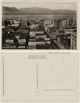
Financial section, Vancouver, B.C.
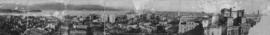
![[Composite photograph depicting the development of downtown Vancouver in ten year increments.]](/uploads/r/null/9/a/5/9a599c6180f7d9caaea4b0a04eb4a5b5827264cb9e9344369b7e06108e425d9c/06f5f827-8afe-43ef-abaf-6e7be6378a75-AM1052P-1011_142.jpg)
[Composite photograph depicting the development of downtown Vancouver in ten year increments.]

Vancouver, B.C. from City Hall

Looking north over Burrard Inlet, showing "The Lions"
Item is a postcard printed with an image of a view buildings in the area of West Hastings Street, including the Dominion Trust Building

Vancouver, B.C. Looking N. from World Bldg.
![Vancouver looking east from [Howe Sound]](/uploads/r/null/6/6/66fa4a6e8bb1ab5d20d8f951fa93ad57dd828be645aff6d182d88a8b36c69281/69bee6e1-54a6-4c8f-a7db-043e03b4dfe6-A23503_142.jpg)
Vancouver looking east from [Howe Sound]
Part of Major Matthews collection
Oblique view. Photograph shows Point Grey, University of British Columbia and University Endowment Lands.
Typewritten letter from Hunting Survey Corporation Limited on verso of print.
![[View looking north from the Hotel Vancouver]](/uploads/r/null/6/4/64b11d9c89a741706ebda07c14cbe1bc9ddece32caf48e09dbd64d52e2f5720a/3a282884-5eb4-435d-8e82-9e8a07c575a5-A23504_142.jpg)
[View looking north from the Hotel Vancouver]
Part of Major Matthews collection
Photograph shows the Marine Building
![[View of Fairview looking north-west]](/uploads/r/null/b/8/b890c9794a5cc39f7be965d287b974abdbc0b3471106801fc91b109db2c3f5d7/15a9e9cc-16d2-4d24-a10b-08e0af9c6892-A23512_142.jpg)
[View of Fairview looking north-west]
Part of Major Matthews collection
![[View of Downtown and the waterfront looking north-east]](/uploads/r/null/6/c/6cff1e9ae582d985f97bb1d48994ec74d160cab5ed6f69ae8f590dd682ad09fd/e7b10570-966f-4553-a7d1-b8b1e1f9788b-A23513_142.jpg)
[View of Downtown and the waterfront looking north-east]
Part of Major Matthews collection
![[Northeast aerial view of Burrard Inlet and Vancouver]](/uploads/r/null/6/6/662502a43d6839b8b0b3518a2f22ca5822fc6dc224c73d5002c705655d5ab329/48aa6304-734e-41ed-8ef2-daffdac1a38d-A23488_142.jpg)
[Northeast aerial view of Burrard Inlet and Vancouver]
Part of Major Matthews collection
Oblique view
![[View across Burrard Inlet toward English Bay from the foot of Trafalgar Street]](/uploads/r/null/6/3/63dcc142e99746062de179b6facfab6fccd8a86241823bbab31d3191a9b5b7c3/c30444a3-8e5d-41dd-b170-5eb3a69913df-A23675_142.jpg)
[View across Burrard Inlet toward English Bay from the foot of Trafalgar Street]
Part of Major Matthews collection
![[Looking north across False Creek from 33 Dufferin Street (East 2nd Avenue)]](/uploads/r/null/1/0/101be9bf6104e3403df3afa6eb0d415584ada39cdff22b13acda8e3b4ff039b7/8f920a96-a3ad-4f39-9e59-636a9cad123b-A25215_142.jpg)
[Looking north across False Creek from 33 Dufferin Street (East 2nd Avenue)]
Part of Major Matthews collection
Photograph shows the Westminster Bridge, Bridge Hotel, the East End School and other buildings in the background
![Race Track - [Hastings] Park](/uploads/r/null/a/e/ae3866984dbd71adb11e4f16a3faeff5c926d7d6dbc7c68bef37bbe9e34f2147/8e72031a-2c43-4d2f-ade2-eaf99cf53105-A44678_142.jpg)
Part of Stuart Thomson fonds
Oblique view showing a view looking southeast along Renfrew Street towards Hastings Street, parts of Wall Street, Trinity Street and McGill Street, the northern section of Hastings Park, the roller coaster, the Manufacturing/Industrial Building and the Exhibition Building on the Exhibition Grounds. The photograph also shows a house at 2950 Trinity Street.
![Grain Elevators and dock - foot of [Commercial] Drive looking east](/uploads/r/null/f/a/fa64fc2fdcd81147912c6227ac42be08f398a362ba801186b73930b6b55d9888/5fb3ff66-892d-4cce-b810-d6918a9c1aed-A44690_142.jpg)
Grain Elevators and dock - foot of [Commercial] Drive looking east
Part of Stuart Thomson fonds
Oblique view showing the Canadian Government Elevator and dock

Looking East showing Second Narrows and North Arm of Burrard (South Shore of Inlet - Hastings East)
Part of Stuart Thomson fonds
Oblique view showing sawmills
View of Kitsilano and False Creek
Part of Stuart Thomson fonds
Oblique view showing Kitsilano Beach, the Kitsilano Trestle and Granville Bridges and Granville Island, the West End and Downtown in the background

Part of Stuart Thomson fonds
Oblique view looking east along Broadway showing Kitsilano, the B.C.E.R. Lulu Island line, and the Kitsilano Trestle and Granville Bridges, Granville Island, Fairview, Downtown and Yaletown in the background

Looking East Along Georgia Street
Part of Stuart Thomson fonds
Oblique view showing Pacific Coast Lumber, boat builders at the foot of Bidwell Street, the West End east of Denman Street and the second Hotel Vancouver and Downtown in the background

Showing Entrance to Stanley Park looking East
Part of Stuart Thomson fonds
Oblique view showing Lost Lagoon, Coal Harbour, Deadman's Island, Brockton Point, Denman Arena, the Horseshow Building and Downtown in the background
![[View of gas barges across from the North Shore]](/uploads/r/null/f/5/f532a779401b63899dd9f520a351d9c66b1c6f1fe87080d5ef15d5420ffd0b2e/456bc880-767f-4bdb-ba7f-8eb508e7701b-A13075_142.jpg)
[View of gas barges across from the North Shore]

![[View looking west from City Hall]](/uploads/r/null/a/4/a4581f880124fe36e4d65ace8fade90fba9c2d4fdcf7cc8831f3d37047f93ade/78b1364a-066c-41a1-92cf-f722a67c4db9-A13741_142.jpg)
[View looking west from City Hall]
![[View looking northwest from City Hall]](/uploads/r/null/d/4/d43ec9df861abb262b4f9e71e1716e62d605faf9ca8af990acf119633ede4f6f/78093dd9-ae46-4259-8fc9-5adcb34ad11d-A13742_142.jpg)
[View looking northwest from City Hall]
![[View of Mount Pleasant taken from City Hall]](/uploads/r/null/c/8/c818f69ed28910f707189f9b866cc01fce61aca5c012774b149232e577f31590/9d8a8f0a-a403-47ea-9475-6fe8db55e672-A13744_142.jpg)
[View of Mount Pleasant taken from City Hall]
![[View of Vancouver taken from City Hall behind the statue of George Vancouver looking northwest]](/uploads/r/null/4/3/435f393b50918db2be608927363c3fa5249883b8b1e8d4073e89eebb8a34cada/c34a7dff-d06a-483c-9dcc-ab176d54afea-A13757_142.jpg)
[View of Vancouver taken from City Hall behind the statue of George Vancouver looking northwest]
Panorama of Vancouver, B.C. Canada
Panoramic view looking north showing Deadman's Island, Brockton Point, part of the West End, Downtown including the Immigration Building, the Marine Building under construction, the Rogers Building, the turret of the Bank of Montreal, the post office clock tower, the Sun Tower, the second Hotel Vancouver and the North Vancouver Ferry in the background
![English Bay, Vancouver, B.C. [at sunset]](/uploads/r/null/1/2/12d397a861ea3910641fa736f0c2d2498d0f2892db2515821653ca2ce6123ad7/ecfa4d63-dc1a-4347-8511-6936ac389a44-A20135_142.jpg)
English Bay, Vancouver, B.C. [at sunset]
Photograph shows a view towards Point Grey

Photograph shows a view looking northwest over False Creek

Photograph shows a view looking north over False Creek including the Westminster Avenue Bridge
![[Vancouver from Mount Pleasant]](/uploads/r/null/2/3/23e8640b2925830ea0753e97d4919c0e7e1e7fa630d8293896a6f5ffbf243cbb/faf31b60-1ab8-4eaf-bca7-34193b1b7d99-A20087_142.jpg)
[Vancouver from Mount Pleasant]
Photograph shows a view looking northeast over False Creek and wooden sidewalks
![[View looking west from the 2100 block Arbutus Street]](/uploads/r/null/f/2/f2921f36729f7e7f64637dcd8a590b2c547e48b5c27666336a0940a66b05944c/687b56f4-2b1d-4517-9192-77c3c9990680-A37758_142.jpg)
[View looking west from the 2100 block Arbutus Street]
Image shows the roof of 2128 Arbutus Street and house at 2134 Arbutus Street.
![[View looking west from the 2100 block Arbutus Street]](/uploads/r/null/8/5/851ca770f427546d3ba4168d0fcc88a31eaf280ccb7c80c81e5cf30f17d55001/b600baa0-0deb-4746-a56e-6cd54646f95d-A37759_142.jpg)
[View looking west from the 2100 block Arbutus Street]
Image shows Clarova Court (2142 Arbutus Street), Arbutus Grocery (2200 Arbutus Street [revised address 2096 West 6th Avenue]), house at 2084 6th Avenue West and St.Augustines Church
![[View looking south from the 2100 block Arbutus Street]](/uploads/r/null/b/0/b0e9b80fdc456d3654fe13d068556ce99c8299a1976a8f559a0678741e06a7a6/620e4de4-8dfe-4c98-9480-ab1f288ec69c-A37760_142.jpg)
[View looking south from the 2100 block Arbutus Street]
Photograph shows an apartment building (2137-2145 Arbutus Street) and houses (2102 and 2116 West 6th Avenue) and the Jones Tent and Awning building in the distance.
![[View of houses and an apartment in the 2100 block 6th Ave West]](/uploads/r/null/f/d/fd16159f16f68de6002a4914d631ff75868f8d5a66e1e71a6f36844ecd89ea40/811691fd-655c-4f14-a3a2-0f3e7c84835f-A37761_142.jpg)
[View of houses and an apartment in the 2100 block 6th Ave West]
Image shows houses at 2116 and 2117 West 6th Avenue.


![[View looking north showing houses and an apartment building in the 2100 block 5th Ave West]](/uploads/r/null/d/e/de8c0e3097234b24035546ee61525654b2458cdc1a63d6990a76aea2dbaf9235/0dd12395-8d1c-4cd6-acf1-063beebfa4fc-A37765_142.jpg)
[View looking north showing houses and an apartment building in the 2100 block 5th Ave West]

[Image shows the back of 2104 West 5th Avenue and the West End in the distance]

Image shows Marca Court Apartments (2085 West 5th Avenue), 2079 West 5th Avenue, 2102 Arbutus Street and 2104 Arbutus Street with a view of the Burrard Street Bridge, the West End and Downtown in the distance.
![[View looking east showing the back of houses in the 2000 block 5th Ave W]](/uploads/r/null/3/d/3d641e57c0fe73884a8468a26d686daf741c27803078b9bc4d3111cd5b7255a3/0d4ee4eb-711b-4feb-adfb-24f70b377ac0-A37768_142.jpg)
[View looking east showing the back of houses in the 2000 block 5th Ave W]
Image shows house at 2104 Arbutus Street and the roof of 2128 Arbutus Street. An election sign for Dr. Parkinson, New Democrat, Burrard is hanging on a fence.

![[Aerial view of Vancouver]](/uploads/r/null/9/b/9b3acec26123edc53f11bf2f41f3286d09254ffea9918cd31b6715395ebe18d0/26473909-fe49-4474-8c3f-05eb1e8ab059-CVA1376-252_142.jpg)
Oblique view showing Fairview, Vancouver General Hospital, False Creek and the Expo 86 and other sites under development on the north side, Granville Island, Granville Bridge, Burrard Bridge, Yaletown, Downtown, the West End, Stanley Park and the Lions Gate Bridge, North Vancouver and The Lions in the background
![[R.C.A.F. Maritime Air Command plane No. 102 flying over English Bay]](/uploads/r/null/1/3/13b6c7a118ed10801cfbe633df28806771f06f62a484edbf5de83c5acd20e0a4/ff8af309-b1af-4c30-9216-ba8a2859660d-A71302_142.jpg)
[R.C.A.F. Maritime Air Command plane No. 102 flying over English Bay]
Oblique view showing the Vancouver Maritime Museum and Kits Point residences in the foreground, and the West End, Downtown, Stanley Park and Burrard Inlet in the background.

Photograph shows houses on Comox Street.

Photograph shows a view looking south from Stanley Park including Shell and Standard marine fuel stations on the inlet and the Marine Building and the Hotel Vancouver in the background