![York House School [students]](/uploads/r/null/5/c/5c577771c70e7f3a4517dbfbb9c3d91bc5c62a45a80d3e2f1e443195e1d45d93/3803d7f0-0e96-4fc3-9ed4-483f49ae2e30-A18455_142.jpg)
- AM1535-: CVA 99-4360
- Item
- June 12, 1933
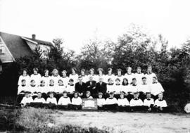
Part of Stuart Thomson fonds
Group portrait
1127 results with digital objects Show results with digital objects
Part of Stuart Thomson fonds
Group portrait
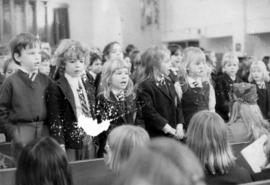
![York House [School] party](/uploads/r/null/7/9/79a8c1b0841547b2701e7134bfa34d4964c52131633650ed116b4bf50e70392e/314f6132-d210-4e69-8eb6-428d91bd8805-A05671_142.jpg)
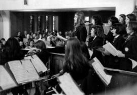
![York House [School] party](/uploads/r/null/d/2/d220b13e6499da1973ce4ed339fcb8939dfd3312c5d0b4e36ae0f41531fe14e5/2599c280-bd23-4ecc-bfc8-cadc02beed61-A05672_142.jpg)
![York House [School] party](/uploads/r/null/4/1/411c5e3033fcd1c268a666826e02a8d443c4c6d795527e5b755d6c6a4e88e824/24d69c56-1895-43cd-aa3c-8af60a4187bc-A05670_142.jpg)

York House School 1933-34 - Vancouver, B.C.
Part of Stuart Thomson fonds


World Peace Pageant - Great Vancouver Young People's Union at Kitsilano High School May 20-21-22
Part of Stuart Thomson fonds
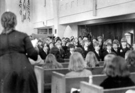
Wilson Heights Junior Choir, winners of Terminal Shield
Part of Stuart Thomson fonds
![[William Coates Taylor, School Trustee]](/uploads/r/null/1/d/1d6fcc6c1e8e3f7519bd52bf8221a3391af54fb693ba310d56bf99f3d305adb4/8d6a1e6f-eac2-40ad-9717-fbf1759970b2-A36109_142.jpg)
[William Coates Taylor, School Trustee]
Part of Major Matthews collection
Head and shoulders portrait
![[War fund promotion at] Point Grey Junior High School](/uploads/r/null/5/7/57d31324de79b2da545423f1ed0af91552d85eaf17927327a880616cf50b9949/226808f8-209a-4924-9be6-7b2bec972f59-A14452_142.jpg)
[War fund promotion at] Point Grey Junior High School
Photograph shows a blackboard listing teams from Kerrisdale and Dunbar
![[War fund promotion at] Point Grey Junior High School](/uploads/r/null/0/d/0d57a3d32d607c2a903289280654374a07c1bfbbae6976f6e87219b6088a9108/e86aa8a1-f3ac-4e4c-9463-d6d05d34e3bf-A14459_142.jpg)
[War fund promotion at] Point Grey Junior High School
Photograph shows a blackboard listing teams from Kerrisdale and Dunbar
![[Walter] Moberly School](/uploads/r/null/0/5/053dde657b6ada643c1761ff3e78549f6b98483049291244d739b2fd49f88851/6d0c6382-11d6-40cf-9ca9-0780a3117eaf-A09620_142.jpg)
Part of Major Matthews collection
![[Walter] Moberly School](/uploads/r/null/f/1/f12858023c2547b5a55996f65eb0ba4c565ec683798d1523fdb43bfa5343487c/6a18343c-d73a-4b4a-b179-c38f476f91b0-A09619_142.jpg)
Part of Major Matthews collection
![[View of] Mount Pleasant School [370 East Broadway from East 10th Avenue and Kingsway]](/uploads/r/null/4/a/4a9c17ea5d268fc17a0c524e5a734a8b8f6233d37b48b2dcecf9afea9c5c9598/908742d8-8944-4b01-ae91-cc8033daa91a-A59088_142.jpg)
[View of] Mount Pleasant School [370 East Broadway from East 10th Avenue and Kingsway]
Part of City of Vancouver fonds
Photograph shows the back of the school facing Kingsway and East 10th Avenue.
![[View of Mount Pleasant from the Lee Block, Broadway and Main]](/uploads/r/null/b/1/b1a10591488c68f9a18122cfa8f608fad319fbfa89c13392ad025d4afb3764d6/e0494038-a598-4615-af30-8ee294062605-A61801_142.jpg)
[View of Mount Pleasant from the Lee Block, Broadway and Main]
Part of Major Matthews collection
Photograph also shows False Creek east of Main, Downtown Vancouver and the Cambie Street Bridge in the background. Some prominent buildings include: Quebec Manor, Arcadian Hall, Dudley Block, Muir Apartments and Mount Pleasant Public School.
Part of Major Matthews collection
Photograph also shows Queen Mary school in the distance.
Vancouver, British Columbia : [urban analysis maps]
Part of City of Vancouver Archives technical and cartographic drawing collection
Maps show land use, land slope and elevation, density of buildings, structural material of buildings, height of buildings, water supply systems, sewage systems, electric power systems, gas trunk systems, population distribution, daytime population distribution, dwelling units, schools, hospitals and doctors, land transportation, port facilities, food manufacturing, textile manufacturing, wood product manufacturing, metal product manufacturing, transportation equipment manufacturing, non-metallic mineral and chemical products manufacturing, retail and wholesale food enterprises, retail and wholesale building materials enterprises, retail and wholesale drugs, general merchandise, apparel and accessories enterprises, retail and wholesale clothing and shoes enterprises, retail and wholesale furnishing enterprises and hotels and eating places in the Greater Vancouver area (including West Vancouver, North Vancouver, Vancouver, Burnaby, New Westminster, the northern portion of Richmond and the western portion of Coquitlam). Much of the data for these maps was derived from the 1961 census of Canada.

Vancouver Technical School Track Team
Part of Stuart Thomson fonds
Group portrait

Vancouver Technical School Matriculation Class
Part of Stuart Thomson fonds
Group portrait
[Vancouver Technical School front entrance]
![[Vancouver Technical School Cadets]](/uploads/r/null/a/e/ae38347b16b3adefbb7a814a0366d7606098bf63c6455ff4c646854f749e1592/84ac9412-dfec-40a4-9188-8c5af24ad608-A32322_142.jpg)
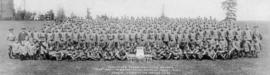
[Vancouver Technical School Cadets]
Part of Major Matthews collection
Photograph shows Captain Elliott, General J.M. Ross, A.C. Bundy and others

Part of M. Etherington fonds
Group portrait
Part of M. Etherington fonds
Group portrait
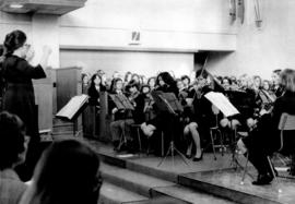
![Vancouver School's Music Teachers [at] Kerrisdale Arena](/uploads/r/null/3/c/3c308fac420bb4e5b092fc3056c437faca8a8822f302ad9a8953a14d76625823/89eadf09-1744-472a-abd8-350b31826911-A72684_142.jpg)
Vancouver School's Music Teachers [at] Kerrisdale Arena
Photograph shows high school bands situated around two conductors on a podium
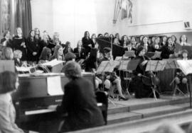
![Vancouver School's Music Teachers [at] Kerrisdale Arena](/uploads/r/null/7/a/7a81251bff3c5a702a31bec037b666c67305d054bc36eb88fd62474a5a203284/a7b2ad12-c1c9-40da-9345-0f9cd6610cd0-A72681_142.jpg)
Vancouver School's Music Teachers [at] Kerrisdale Arena
Photograph shows high school bands situated around a conductor on a podium
![Vancouver School's Music Teachers [at] Kerrisdale Arena](/uploads/r/null/a/7/a7997bbbe411478e94ee2a4cb530f6a7eaadd98247aff6d19d6c2fb34608495c/59c7be9c-a88f-4472-b744-66e4c1f99608-A72679_142.jpg)
Vancouver School's Music Teachers [at] Kerrisdale Arena
Photograph shows high school bands situated around a conductor on a podium
![Vancouver School's Music Teachers [at] Kerrisdale Arena](/uploads/r/null/c/4/c4f6008e46d6e320fbfde7b7e607385c0053873084c94e7a919b69e8e3c00a55/6bbaa43f-813a-4bf3-895d-7e4f20d6715e-A72682_142.jpg)
Vancouver School's Music Teachers [at] Kerrisdale Arena
Photograph shows high school bands situated around a conductor on a podium
![Vancouver School's Music Teachers [at] Kerrisdale Arena](/uploads/r/null/f/8/f843eaeed70937f9133955f164b5e0907af14d827badd18cc08fa1c1167e8897/45ef6d97-6d6a-4077-a1f2-21489bac9066-A72683_142.jpg)
Vancouver School's Music Teachers [at] Kerrisdale Arena
Photograph shows high school bands situated around two conductors on a podium
![Vancouver School's Music Teachers [at] Kerrisdale Arena](/uploads/r/null/8/a/8ab7e06104db7e44f1f6473cab19fd983dfe53c79d99356ae1b3168d087ce863/2caae20b-0503-4b19-ab73-8fa62cfda0b8-A72685_142.jpg)
Vancouver School's Music Teachers [at] Kerrisdale Arena
Photograph shows high school bands situated around two conductors on a podium
![Vancouver School's Music Teachers [at] Kerrisdale Arena](/uploads/r/null/1/f/1f174ef9b96fbe300c7c7525fc7f967e5d2e274047a6bbb59b46d5586da0d027/865e2c40-170a-4fca-bc05-56b3f9c23876-A72691_142.jpg)
Vancouver School's Music Teachers [at] Kerrisdale Arena
Photograph shows high school bands situated around a conductor on a podium
![Vancouver School's Music Teachers [at] Kerrisdale Arena](/uploads/r/null/3/2/3205dc5ad49ebdf00ca7991ad6e99b7d69e26a455b312677417dc85c1b4b55e4/c950e423-4f55-4563-bc28-a1f61596f487-A72687_142.jpg)
Vancouver School's Music Teachers [at] Kerrisdale Arena
Photograph shows high school bands situated around a conductor on a podium
![Vancouver School's Music Teachers [at] Kerrisdale Arena](/uploads/r/null/1/f/1f55dcd0c27a913ec9f455c6d0a261f139afa5ad11b0ce59d0cfe357e2492800/d781a365-eb43-4290-a6ac-bcdfe41b59d4-A72678_142.jpg)
Vancouver School's Music Teachers [at] Kerrisdale Arena
Photograph shows high school bands situated around a conductor on a podium
![Vancouver School's Music Teachers [at] Kerrisdale Arena](/uploads/r/null/b/c/bc67612906b33069cdaec9468681c41ce8d31cfaf0051628ff60799d6b6eacfe/c561f15d-80bf-45e6-ad62-a6f1e542ec55-A72680_142.jpg)
Vancouver School's Music Teachers [at] Kerrisdale Arena
Photograph shows high school bands situated around a conductor on a podium
![Vancouver School's Music Teachers [at] Kerrisdale Arena](/uploads/r/null/b/5/b56b1648bf81aa76d86e99d888be2c93036ac6b66823d5cd9ead081ed018e14a/e8fd20ad-fb02-48c2-b1e2-532ce02ee08b-A72686_142.jpg)
Vancouver School's Music Teachers [at] Kerrisdale Arena
Photograph shows high school bands situated around two conductors on a podium

Part of City of Vancouver fonds
Item is a map showing locations of elementary, junior high, junior-senior high, and senior high schools in Vancouver. Map has been annotated with blue and red check marks next to some schools, but lacks explanation of what the marks mean.