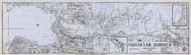
Item is a set of maps printed on one sheet. The main map shows an isometric view of the port of Vancouver from Stanley Park through the Second Narrows Bridge (including North Vancouver). The perspective point appears to be located above the Granviile Street and West Georgia Street intersection. Note that the isometric view of locations west of Granville Street is from the south-east, rather than the south-west, as indicated in the title.
The map depicts the port infrastructure, including piers, drydocks and companies located in the port.
The inset maps are a key plan showing the location of the port relative to the Lower Mainland as a whole, and a larger-scale map entitled "Plan of the Port of the City of Vancouver from Coal Harbour to Second Narrows". It contains more detail about the names of the various piers, drydocks and companies and shows the North Vancouver port facilities as well as south shore ones.
![[View of the harbour, C.P.R. Pier 'D' and railroad yard from the roof of the Post Office]](/uploads/r/null/e/4/e403caef05acedfc9e78203f7cac185e22853ec36a357deb2f1e3cbb517c0f44/0ce56549-03f9-4349-9a5e-267ba26928df-A09879_142.jpg)
![[View of the harbour, C.P.R. Pier 'D' and railroad yard from the roof of the Post Office]](/uploads/r/null/0/0/0017cc41004f72fbc45775cf71b997df93d9562b9877c14a78d5a30c67506a85/99ef2020-d62e-4cd3-b0b2-d2a012ec9e1f-A09878_142.jpg)
![[View of the harbour from Spencer's Department Store]](/uploads/r/null/2/0/202e8d9d731fb703dfc9c1c09d19f811ee159ca535e8b61865f31dadd624551c/2a899800-eecb-49bd-9760-2d8c09ed120c-A09877_142.jpg)
![[Aerial view looking east over Stanley Park, Coal Harbour and Burrard Inlet]](/uploads/r/null/d/0/d02fee694c486ac2accdeefb505d0dae5fcb42789ef16de49322d845e3c04b44/be8c34ce-7c09-4c0e-a395-f083c9134080-A43248_142.jpg)
![[Looking east from the Stanley Park bridge to Coal Harbour]](/uploads/r/null/c/5/c5d5a12a1c9782ab5a8523900877fe279312841636d16b6c49d45f78c661b618/886c6082-bc19-41a2-a743-6880e2727074-A43209_142.jpg)
![[Northwest view of Vancouver from Dunsmuir and Hornby Streets]](/uploads/r/null/8/8/88e94ad7604ed40fb7780d502fd141151ebddd9bddf50fa36b4b55a7abda9b58/e8c12a8c-3224-4083-b222-e4b83a4a6952-A65789_142.jpg)

![[View of] Coal Harbour and Stanley Park from Georgia [Street]](/uploads/r/null/8/c/8c0a3b0f859c1a378c1463bc15fea75d46976a8289b6c84fcabef3840f06a3b3/490e919d-235c-4eb3-8693-3641e4b6285c-A09696_142.jpg)
![[View of ship in Coal Harbour and Deadman's Island, from foot of Bute Street]](/uploads/r/null/c/a/ca08065478426138b96322562f2e229721e66f75053f6ef16a6f73c655815bf9/e78cbbbf-fc54-4725-a7a8-7bbee9ee0162-A07648_142.jpg)
![[View of Coal Harbour, Deadmans Island, and North Shore mountains from foot of Thurlow Street]](/uploads/r/null/4/c/4ce8248f3e2c6a40b98fe6815778e930d730e9bc6fef96c61b3f9f0715075431/ed4d630a-fcce-461f-aaaa-3bab818f9bc6-A07647_142.jpg)


![[Rowboats in harbour for regatta]](/uploads/r/null/0/d/0debb603b15a961c88309aaea8f43a2a6071bc64a914c4d177f25725d819bf71/f245e588-08f5-44ff-866e-2aa5791bb9c5-A07612_142.jpg)
![[Rowboats in harbour for regatta]](/uploads/r/null/9/d/9d458757030e0adf87d4850d9f3f4fc08b05bd5f17091a77b867ead298e8110e/dc3b04e5-0d4d-4ef6-b733-b8b52c8fcbef-A07610_142.jpg)
![[Rowboats in harbour for regatta]](/uploads/r/null/c/c/cc6de5eac46bac119c80428ac7b02ed401de255fc62ef6a89d136494921240de/fc5264d2-3ab8-4a84-9dcd-bdeb27fc0afd-A07608_142.jpg)
![[View of Pender Street between Burrard and Thurlow Streets, showing ships in harbour]](/uploads/r/null/7/8/78e5ebf660d4be04085232c4df48a55b2f53fc69b8b24917d11a327c279b273e/238ef5af-164f-4608-b421-7f1ea11419d7-A07605_142.jpg)
![[View of clearing at foot of Burrard Street, showing ships in harbour]](/uploads/r/null/7/8/78b3af6cd868bbad006ed34e13d07aa777902e54bdd3decb808046646b9b01a3/842ea67f-73eb-447a-adf2-428d6245779a-A07604_142.jpg)
![[View of Pender Street between Burrard and Thurlow Streets, showing houses and ships in harbour]](/uploads/r/null/f/0/f00ac5f1f323bcee985db1f23354ad1a01e377075c05ff005e8291cfa6ea59bb/257c6f06-9e48-4b7a-8964-00daf6a2493f-A07603_142.jpg)
![[Sailors rowing to shore from the H.M.S. "Amphion" in Vancouver harbour]](/uploads/r/null/9/b/9bfc3c89bfb227c2ed0b8630533f99722a1277d24cb1e70d34c7740bb5438220/9d00534a-5cfe-42bf-819c-c9fceb9dbf60-A07602_142.jpg)

![[Northeast view of downtown Vancouver from the roof of the Hotel Vancouver]](/uploads/r/null/d/e/de95d099d1517793665187336820ebdb65db9f066b651b935a78788383053fb3/5b49058f-4381-43c8-b28f-9755248fa953-A63006_142.jpg)
![[View of Coal Harbour and the rear of Queen Victoria's Memorial from Stanley Park]](/uploads/r/null/4/3/43de497a997e0f724c44d286a5777cf01177bc80cf064bb190ff8d322f1a3431/ab850521-fb13-4aa6-8b76-7ae76dab47a7-A64524_142.jpg)


![Vancouver Harbour Sept. 1913 [showing the C.P.R. Station and yard and Pier D under construction]](/uploads/r/null/0/5/056455d9e690740168b8f4ae0d8d18b148b46061376f6b258e46b96ab0527cb1/82d16629-54f2-49c5-9a22-bf507e3921f0-A63186_142.jpg)
![[View of water front showing the C.P.R. station and yard and Pier D under construction]](/uploads/r/null/2/7/2781b7cdfb12c9119a5fca39a4be76488e2a9adc05038f861af4810c250356bf/2ca5a454-46e7-41c1-84fb-580e4bc03252-A63185_142.jpg)
![[View of Coal Harbour showing Pier D, dredging, and C.P. railway yard]](/uploads/r/null/a/f/af0c10ae5aeb61ca4a197b4e372f1862f6fa32fb58347e2b94148897eec5e3c3/a7b91197-362d-42d1-b2a2-df14d10f4656-A63942_142.jpg)
![[Northern view of downtown Vancouver from World Building, 500 Beatty Street]](/uploads/r/null/9/9/997cc0ffa3d5b19d17a58c9f16a1c6f9855c9019e5f3249c78d456803ea58779/b52f219d-f015-40b1-96a6-c089ab3c8d70-A63175_142.jpg)
![[Northern view of downtown Vancouver from the World Building at 500 Beatty Street]](/uploads/r/null/c/5/c5a97982fe48806e527a2356c3596800ee386904520184558d1eb65128635907/f3ea7ce2-2a4c-40da-a5a9-2ccfa6c170b1-A63886_142.jpg)
![[Northern view of downtown Vancouver from the World Building at 500 Beatty Street]](/uploads/r/null/9/5/95cc16c6b26e463eb28bc5ac8abec9ec6723150a2aefbca7850f264a2adff766/e88985ba-abeb-4d06-8eea-2bf10a834381-A63885_142.jpg)
![[Northward view of Downtown Vancouver from the tower of the Vancouver Block]](/uploads/r/null/7/e/7e88d0ca5a3c8b27417b0772731b3b9c8e8116caba7efef77325c3bfdf9ef14d/7ff76790-0eb3-4328-b584-8e7978589537-A63884_142.jpg)
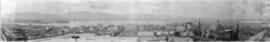
![[360 degree view of Vancouver from the roof of the second Hotel Vancouver]](/uploads/r/null/7/2/72f205b48502a927912ec46b74aa571f102f387013c2d6bce557a2420fd72aa7/269934f7-d517-4c58-b633-4167772f935b-A63168_142.jpg)

![BC [British Columbia] postcard - The Rockies to the Pacific](/uploads/r/null/1/2/1226936/e2a6b4cf-7e7e-48c3-8e3b-6a150d917129-MI-342_142.jpg)


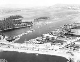
![[Aerial view of Vancouver Harbour from Stanley Park looking east to Indian Arm]](/uploads/r/null/c/b/cb066fdc626d69001bfb4c896937f586737298cc09ee0de3cc7fdd0bca8df09e/93414b9d-edd5-4e76-a79d-fb7a26360472-A31831_142.jpg)
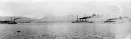
![[Ships in Vancouver Harbour]](/uploads/r/null/d/6/d629566f7cb9f7a78af71c85ba3ea4a2cf7167728b91400cee1d65fd777443b3/fbfab785-d4fa-4637-8632-cf9d4b4bddca-A08055_142.jpg)
![[Vancouver Rowing Club clubhouse and dock, in Coal Harbour at the foot of Bute Street]](/uploads/r/null/d/2/d2f7d67e632b7c2d17d9142941c783d2817e1558aba2c484ce203583c6a8b56a/2fcab23e-13cb-44cf-890c-3ddcdfa34b69-A08054_142.jpg)