![[Aerial photograph of downtown Vancouver and Burrard Inlet waterfront]](/uploads/r/null/8/8/880f3eb359e4ba87a53dbb1528c9a52637f0890bd7fa1f026f2a2f8d55770b5f/07f1720e-3884-4019-874b-7ae1f538a5ea-A38733_142.jpg)
[Aerial photograph of downtown Vancouver and Burrard Inlet waterfront]
- AM1399-S3-: CVA 1399-418
- Item
- 25 June 1964
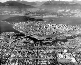
Aerial photograph looking west down Georgia Street, showing Lost Lagoon and Coal Harbour
[Aerial photograph of downtown Vancouver and Burrard Inlet waterfront]
Aerial photograph looking west down Georgia Street, showing Lost Lagoon and Coal Harbour

Aerial photograph of downtown Vancouver and Burrard Inlet waterfront
![[Aerial view of] downtown bounded by Burrard Street, West Georgia Street, Granville Street and Sm...](/uploads/r/null/9/1/a/91aa0079c35a13cc3a22b0f7df0fb214970095aab0b5d871e09523e0499e3dac/42b18aee-e75f-4548-9e3a-bf196c0130ce-CVA145-17_142.jpg)
Part of City of Vancouver fonds

Aerial view of New Brighton Park site, looking east from Renfrew Street
Part of Wilson family fonds
Image shows grain elevators and Canadian Pacific Rails.

Aerial view of New Brighton Park site, looking west along waterfront toward foot of Renfrew Street
Part of Wilson family fonds

Aerial view of P.N.E. Playland
Item is a photograph depicting an oblique view showing the roller coaster and rest of the amusement park.
![[Aerial view of the University of British Columbia campus]](/uploads/r/null/3/b/3b26ad7abfb1609951345f3da59b98d3acb9e35f6e934378ca7fe7b7f51bc1d6/60118a86-5a6f-4ba9-b3b3-f32583aabd22-A23508_142.jpg)
[Aerial view of the University of British Columbia campus]
Part of Major Matthews collection
Oblique view. Photograph shows the University Endowment Lands.
![[Aerial view of Vancouver General Hospital complex]](/uploads/r/null/0/b/0/0b051003f4129ccb3a10f83c721878865509cd6ebfc12da14ed1309cec7b5aa0/f30b5587-d175-4041-ad8c-5703a5db260b-CVA1399-624_142.jpg)
[Aerial view of Vancouver General Hospital complex]
Oblique view showing King Edward High School and False Creek
![[Aerial view of Vancouver General Hospital complex]](/uploads/r/null/c/c/b/ccbd0b591ebec85e171caa06a1ebf508517f73a7f475af01cecc469616c2990c/c26a808e-5db5-4adb-a9e4-37fbf69526f0-CVA1399-623_142.jpg)
[Aerial view of Vancouver General Hospital complex]
Oblique view showing King Edward High School and False Creek
![[Job no. 794 : aerial photograph of Vancouver General Hospital Complex]](/uploads/r/null/c/3/c38902ff2c77f0c596178d5bad0a56cb37faccbe6cd068ca4801f44fb56c8925/cbc7c0a4-281a-4ba6-934c-7849a4d720c6-A38054_142.jpg)
[Job no. 794 : aerial photograph of Vancouver General Hospital Complex]
Photograph shows oblique view of V.G.H. and surrounding area taken from the west
![[Job no. 794] : aerial photograph of Vancouver General Hospital complex and surrounding area](/uploads/r/null/a/7/a7db321ff6eeb9aabf663f37e723906fef772ef0c0d1372c083ffd18ff80a6bf/b3bf7b15-0b22-4c8b-84de-5cecf42d5a03-A38051_142.jpg)
[Job no. 794] : aerial photograph of Vancouver General Hospital complex and surrounding area
Photograph shows oblique view taken from south west
Vancouver from the air looking north from over Little Mountain
Part of Major Matthews collection
Oblique view. Photograph shows Fairview, False Creek, R.C.A.F. Equipment Depot, Granville Island, Burrard Bridge, Granville (Street) Bridge, Downtown, West End, Stanley Park, Vancouver General Hospital, First Narrows and Burrard Inlet.
![[View looking northeast from north shore of False Creek over Smithe Street]](/uploads/r/null/8/f/6/8f6d7814ac04d1498743ba52bf07caf7e8dd2cf0290eb319665712b1edfdc180/c5c831e7-835b-48ff-8c87-5c157412dc0c-CVA145-2_142.jpg)
[View looking northeast from north shore of False Creek over Smithe Street]
Part of City of Vancouver fonds